Ever got to the city end of the Eastern Freeway and thought “if only this freeway went somewhere, all of these traffic jams would disappear”? Well Melbourne has already tried doing that to every other freeway, and it doesn’t seem to be working.

We’ll jump back to 22nd May 1970, when The Age covered the opening day of the South Eastern Freeway, which then run between Punt Road in Richmond and Toorak Road in Kooyong.
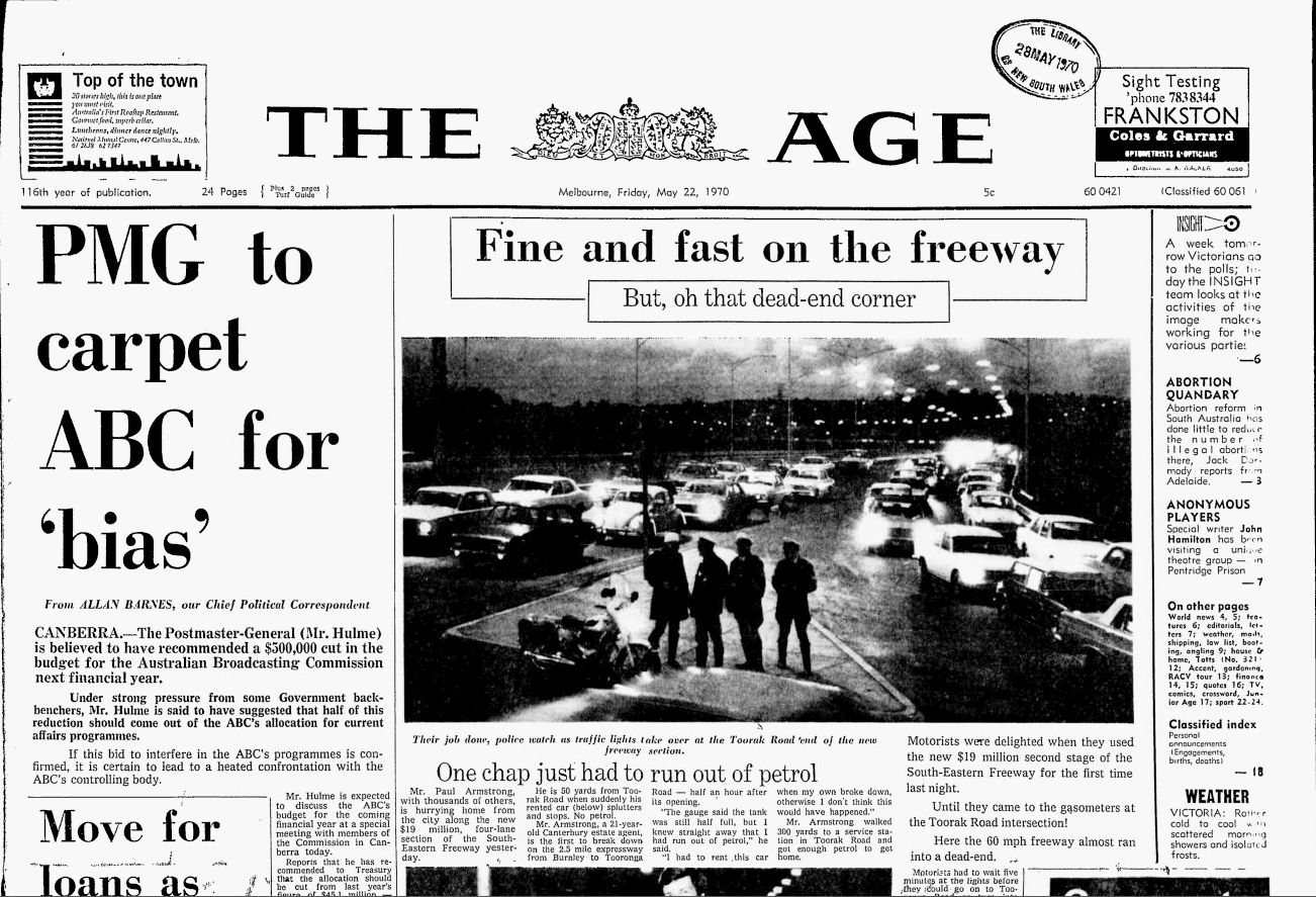
Even in the 1970s ending a freeway with traffic lights was the butt of jokes.
Fine and fast on the freeway
But, oh that dead-end cornerTheir job done, police watch as traffic lights take over at the Toorak Road end of the new freeway section
Motorists were delighted when they used the new $19 million second stage of the South-Eastern Freeway for the first time last night. Until they came to the gasometers at the Toorak Road intersection! Here the 60 mph freeway almost ran into a dead-end.
Motorists had to wait five minutes at the lights before they could go on to Tooronga Road or turn into Toorak Road. Traffic from the freeway also disrupted traffic travelling east in Toorak Road. And cars were banked up from the freeway intersection back to Kooyong Road at the height of the peak period.
The Minister for Local Government (Mr. Hamer) opened the freeway. He said it would save the community $15,000 a week by reducing accidents and cutting travelling time. “The Board of Works was justified in using all reasonable means to get the road ready and in use at the earliest date,” he said.
While one wag managed to run out of petrol, blocking the new road.
One chap just had to run out of petrol
Mr. Paul Armstrong, with thousands of others, is hurrying home from the city along the new $19 million, four-lane section of the South-Eastern Freeway yesterday.
He is 50 yards from Toorak Road when suddenly his rented car (below) splutters and stops. No petrol. Mr. Armstrong, a 21-year-old Canterbury estate agent, is the first to break down on the 2.5 mile expressway from Burnley to Tooronga Road – half an hour after its opening.
“The gauge said the tank was still half full, but I knew straight away that I had run out of petrol,” he said. I had to rent this car when my own broke down, otherwise I don’t think this would have happened.” Mr. Armstrong walked 300 yards to a service station in Toorak Road and got enough petrol to get home.
But the reasons for rejecting freeway building were also the same – they are expensive and polluting, delivering marginal savings in travel times while moving congestion elsewhere.
Quicker
Mr. Hamer was jeered by a small group of banner-waving trainee teachers as he cut a blue ribbon to open the new section. One of the demonstrators, Andrew Moffat, of Hallam, said the money should have been spent on schools. “Freeways, with the increased number of cars they handle, add to pollution of the atmosphere. “I can’t see why this money could not be spent on schools or something else more worthwhile,” he said. The chairman of the Board of Works – (Mr. Croxford) said rain had stopped workmen painting traffic lanes on the new freeway.
Travel time
He advised motorists to drive carefully and not to overtake other cars until the lanes were painted. The new freeway section cuts about 2 1/4 minutes from the travel time to the city. From the traffic light forest at the Toorak Road intersection it lops less than a tenth of a mile off the trip. Last night’s times along the freeway averaged 10.5 minutes.
In off-peak traffic – even with the level crossing trams and four sets of traffic lights – the average time was 13 minutes. Under the yellow sodium lights cars ducked and weaved to keep up to the 60 mph speed limit. They banked up 20 and 30 deep at the Toorak Road intersection and other bottlenecks. There were no lane markings, apart from two short strips of reflecting “cats’ eyes”. And warning lamps guarded an unfinished section of one ramp.
Still, some people thought the new freeway would solve Melbourne’s traffic problems, such as MLC Geoffrey John O’Connell for Melbourne Province during the 25 March 1970 debate on the Richmond and Hawthorn Lands Bill.
My party has no objection to the Bill. The Melbourne and Metropolitan Board of Works has performed good work on the South Eastern Freeway. When this four lane highway is fully operative, many of Melbourne’s traffic problems, particularly in this area, will be solved.
But the traffic problem was never “solved”.

Throughout the 1970s the Mulgrave Freeway was progressively extended toward the Melbourne CBD from Dandenong towards Chadstone, reaching a dead end at Warrigal Road in 1981.
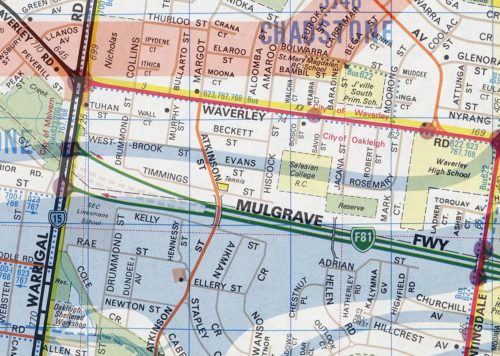
Melway Map 69 Edition 14, 1982
During a 1981 debate on funds for rural roads, Labor MP Steve Crabb questions whether ‘salami tactics‘ were driving the expansion of Melbourne’s freeway network.
Mr CRABB-
The fact is that everybody in the community is disadvantaged in terms of roads because the Government continues to pursue the construction of crazy freeway schemes
that have been on the planning books for a decade. The people who are disadvantaged are the people who want to use the ordinary, basic infrastructure of roads both in the city and its suburban areas and in the country.Mr Maclellan-
We have stopped building freeways.
Mr CRABB-
I am surprised that the Minister keeps raising this matter. He raises it every time we discuss this subject.
The Government has never come clean on what it proposes to do about linking the Mulgrave Freeway with the South Eastern Freeway, but it intends to proceed with a project which will
cost some $120 million and which will require, by definition, an expansion of the capacity of the South Eastern Freeway to at least three lanes in each direction.That will inevitably lead to a linking of the F19, the West Gate Freeway, with the South Eastern Freeway by means of a tunnel under the Yarra River. Nothing is surer than that, if the Country Roads Board is allowed to continue with the policy the Government has given it, that is where we will end up!
Insufficient road funds are spent in both country and suburban municipalities, as all honourable members know. The money that ought to be spent on those roads is being expended on the grandiose schemes of a Government that has not got the capacity to reorient its policies from those established ten or twenty years ago.
The “missing link” between the South Eastern Freeway and the Mulgrave Freeway was eventually opened as the “South Eastern Arterial Road Link” in 1988, but in a nod to freeway objectors, was built with traffic lights at intersections instead of flyovers.
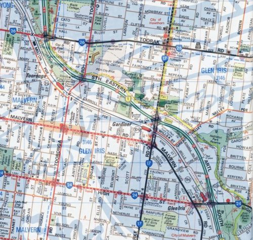
Melway Map 59 Edition 20, 1990
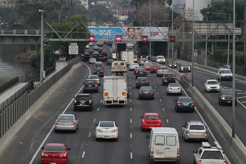
But even that wasn’t enough to solve Melbourne’s traffic – a flood of other upgrades have been completed on what is now known as the Monash Freeway.
- 1994 – Warrigal Road traffic lights replaced by overpass.
- 1996 – Tooronga Road, Burke Road and Toorak Road traffic lights replaced by overpasses.
- 2000 – CityLink project widened freeway to three lanes between Toorak Road and the city, along with connection to West Gate Freeway via the Domain and Burnley Tunnels.
- 2010 – freeway widened to four lanes between Dandenong and the tunnels.
- 2018 – freeway widened to five lanes between EastLink and the South Gippsland Freeway.
- 2019 – work starts on widening to five lanes between Warrigal Road and Eastlink.
Money well spent?
Footnote
Here is a map showing the development of Melbourne’s freeway network from 1970 to present day, from the North East Link Project, Appendix C “Transport Assessment – Existing Conditions and Future No Project Scenario” report dated February 2018.
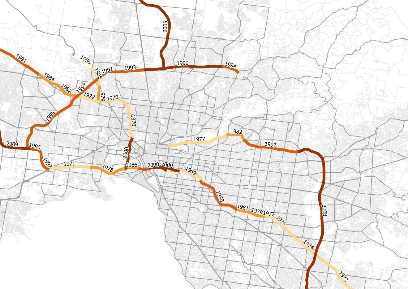
It only details the opening date of freeways, not the endless procession of widening projects.

Bet they are kicking themselves for not doing a ground level north east link and eastlink. We could have been toll free on both roads by now.
The Greensborough Bypass is pretty much a freeway minus grade separation – the Plenty River crossing was initially a single bridge, the second carriageway coming later.
https://elthamhistory.wordpress.com/2018/06/21/throwbackthursday-greensborough-bypass-construction-1986/
The gap between the Mulgrave Freeway and South Eastern Freeway was probably the one most mired in politics owing to the short section of the road and residential objections along Gardiners Creek valley. The F9 South Eastern Freeway was built outward by the MMBW in 1962 and 1970 with the F14 Mulgrave Freeway built inwards from Doveton to Chadstone between 1972 and 1981. The two sections were separate routes – one was to join the Healesville Freeway and the other the Tullamarine Freeway but the space was there to join the two which was part of the never built F6.
It was one of the 1969 Melbourne Plan sections deleted by the Hamer Government in 1974 but it seems in the background the pressure was there for it to resurface – at the Mulgrave Freeway end there were pavement stubs included just before Warrigal Road under the Atkinson Street bridge. The wind back was at a time when the Whitlam Government was withdrawing Federal funds for such projects
https://news.google.com/newspapers?id=DlUQAAAAIBAJ&sjid=M5IDAAAAIBAJ&pg=5016%2C3042553
By the mid 80’s the residential objections had waned somewhat with stop and crawl traffic much of the day along Waverely Road between the two sections so the generally anti-freeway Cain Government had the South Eastern link built in 1987 with at-grade intersections at Warrigal, Burke, Tooronga and Toorak Roads with the Warrigal Road intersection formed by the off ramps and the space remaining for an overpass in the centre. Bridges were built elsewhere including a half-diamond interchange at High Street. To placate residents new-style sound walls were provided as well an an early variable speed limit – the 100km/h signs by day had hinged flaps that switched over at night to read 60km/h
It was under the Kennett government the intersections were removed along with the night time slowdown in the mid 90s and an expansion from four to six lanes, later eight lanes in 2010 with these bare fitting in at High Street and Moira Street.
The elephant in the room with increased congestion is the rapid population growth – when Citylink was completed in 1999 Melbourne was just under 4 million people and within two decades has topped 5 million people. When you build new infrastructure it is soon accompanied by new estates on the fringe – new railways do the same thing with developers filling up the Pakenham corridor quickly with the same thing happening to Cranbourne once it got suburban trains in 1995 (notably it lagged places like Berwick at the time probably for this reason). The extensive electric system Melbourne had in the 1920’s was more or less a sitting duck for post war growth with suburbs filling up along the rail corridors first with the gaps not-so well served like Rowville filling later.
More recently we have seen developers build along the Whittlesea line in light of the train to come – now they’re at Mernda one could imagine they will push the urban boundary to the former terminus. I suspect now the looming electrifications to Melton and Wyndham Vale will see the suburbs fill the remaining space out west, followed by renewed pressure on the East West proposal – the cycle continues!
Thanks for the extra history there about the final link.
Building freeways encourages people to drive, building and running decent public transport encourages people to use public transport. People don`t drive on roads that are not there or use decent public transport that isn`t there, so what is and is not built has an effect on which mode people use.
How about an article on how great Melbourne would be without the excessive mass population?
Benefits would be low pollution, positive impact to fighting climate change, lots of spare money for trains and other exciting things.
Without the freeways built above, there would be no industry here (even that has been sliding downwards thanks to China).
If Melbourne was smaller it would do SFA for reducing pollution or fighting climate change – the people would still need to live *somewhere*.
It does raise the question about what’s better for the environment – dense living in concrete skyscrapers but people can walk to where they need to go, or sprawling suburbs of timber houses but people have no choice but to drive everywhere.
I had a read of an mmbw report in regards to sporadic freeway construction. It was said because there was such objection from certain communities about the 1969 freeway plan for Melbourne the mmbw began building bits of freeway that were considered essential to Melbourne’s vehicle transport. The idea was that if you build it, they will come. And they did. Plenty of cars would travel on a fwy that would end at the most inconvenient place and dump traffic onto roads that couldn’t handle concentrated amounts of freeway traffic. The worst part was that the freeway ended in suburbs that communities were initially apposed to the freeway in the first place. So these residents were held to Ransom and eventually went from being apposed to freeways to being in favor of freeways. Unfortunately freeways create concentrated amounts of traffic. Look at any on/off ramp intersection of a fwy n peak hour. I live 2kms from Edgar’s Rd and the metro ring Rd intersection and take my son to school daily. Some days you can’t even cross the intersection because the amount of traffic putting off the fwy blocks the intersection and creates a chain reaction effecting Edgar’s RDS traffic flow creating more traffic banking up on Edgar’s Rd and side streets.
Here’s a piece on the 1970s Melbourne freeway revolts:
http://www.ycat.org.au/1977-the-battle-of-alexandra-parade/3/
I recall being told by a young visitor to Melbourne, many years ago, that if they narrowed Dandenong Rd (and presumably all other similar sized roads) to two lanes each way, Melbourne would shrink to a manageable size.
The funny this is that we widened the likes of Dandenong Road towards the city back in the 1960s, way before the “immigration overpopulation” argument existed.
Building bits at a time is the way they prefer. Look at the Dingley Bypass how it ends up at South Rd. In the years to come that intersection will be a mess. The residents in that area are already making noises about the increased traffic. The “solution” will be to build a tunnel under Bentleigh connecting this road to the Nepean and then feeding traffic up to Punt/Hoddle (where they are now amending intersections to improve flow). The next step will be to build a connector road b/w Hoddle and the Metro Ring Road to connect this up to the Hume and have a Melbourne (north-south) bypass. And there you have it – the 1969 MMBW plan coming to life bit by bit. Out of interest, do any of you have an opinion re: north-east link and do you think Option B or C would’ve been better.
“Salami tactics” is the name for it.
https://www.danielbowen.com/2010/11/04/freeways-salami-tactics/
I’d prefer option B or C – option D was too far out, and option A funnels traffic into the city.
https://www.abc.net.au/news/2017-08-08/north-east-link-four-corridor-options-compared/8782898
[…] Opened back in the 1990s, it was widened in stages from 2009, with the final section completed in 2018. How long until the next ‘upgrade’? […]
[…] 1970 the South Eastern Freeway was extended east to Toorak Road in Kooyong, where it ended at a set of traffic lights. The “missing link” […]
>>> 2018 – freeway widened to five lanes between EastLink and the South Gippsland Highway.
I think the intersection is with the South Gippsland Freeway, not the South Gippsland Highway.
Oops – fixed!