Melbourne has the largest freeway network of any Australian city, and with it, possibly the country’s largest collection of ‘ghost ramps’ – pieces of freeway that lead nowhere.
Planning for a future that never came
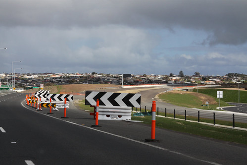
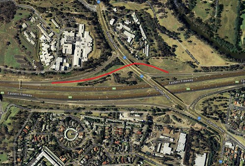
The best known bit of ghost roadway is the incomplete ramp at Chandler Highway on the Eastern Freeway, along with an associated road overpass. Marked in a number of Melway directories since the freeway opened in 1977, the ramp was intended to take eastbound traffic beneath the Chandler Highway and then onto the proposed E6 freeway, which has never been built. The alignment remains in place today, along with a short piece of roadway leading from the in-use off ramp.
It still might happen
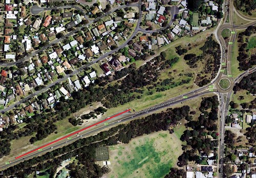
Ghost ramps also exist for a partially completed roads, such as the Mornington Peninsula Freeway at Jetty Road in Rosebud South. The freeway itself opened between here and the Nepean Highway at Dromana in 1975, but in the 1980s it was decided to extend the freeway a short distance west towards Boneo Road.
It was decided to only build the southern carriageway of the road and omit the freeway overpass at Jetty Road, leaving a road towards Portsea to be built on the alignment of the future westbound entry ramp, leaving large earth embankment at the city end of the road, and a short road to nowhere where the future freeway will land.
Moved due to new roads
Not all ghost ramps were built for never-completed freeways – some were closed as part of road upgrades. The Police Road outbound on ramp to the Monash Freeway is one opened around 1994 to allow traffic from Waverley Park to access the freeway.
With the construction of the Eastlink – Monash Freeway interchange a short distance to the east, the ramp was closed in 2005 due to concerns about traffic weaving, being replaced by a new ramp a short distance away at Jacksons Road. Today only minor traces of the ramp remain along Police Road.
Unsafe and redundant
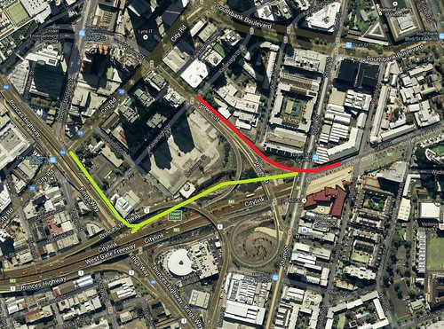
A longer lived ghost ramp can be found at Church Street on the Monash Freeway. Originally opened in 1962 as part of the South Eastern Arterial from Punt Road to Burnley Street, two ramps were provided for eastbound at Church Street: the first for northbound traffic towards Richmond, and a second one that did a loop and directed traffic south towards Prahran.
With the construction of CityLink during the late 1990s, the tight curve for the loop was determined to be unsafe and the ramp being closed to traffic. After sitting idle for over a decade, Yarra Council has allocated $1.1 million in their 2013/14 budget to convert it into a park, the work completed in 2015.
Leading into the darkness
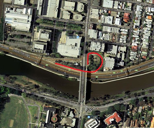
Safety concerns also led to the closure of a different ramp on CityLink, this time at Power Street. Opened with the Burnley Tunnel in 2000, the ramp allowed traffic from the Melbourne CBD to access the westbound tunnel, joining the main traffic lanes a short distance inside the tunnel.
Asking the average Melbourne motorist to merge while inside the tunnel must have been too much of an ask, as in 2009 the ramp was closed as part of the Monash-CityLink-West Gate upgrade project, replaced by a new ramp from City Road, that merged with the existing Kings Way ramp outside the tunnel. The unused ramp remains in place today, but fenced off.
Omitted as part of an upgrade
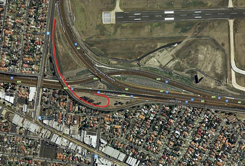
Another former off ramp that still exists is located at the merge between the Tullamarine and Calder Freeways in Airport West. Originally opened in 1972, the interchange permitted traffic movements in all directions with a ‘trumpet’ layout.
Constrained by the adjacent airport, as traffic on the freeway increased over the years, congestion at the merge led to the interchange being rebuilt in 2005-07, with the airport bound carriageways being relocated to the centre of the freeway, and the former south to west ramp was closed, as the movement had been replaced by the opening of Western Ring Road some years earlier. Today the bridge and pavement remain in place, disconnected at both ends.
Catering to increasing traffic
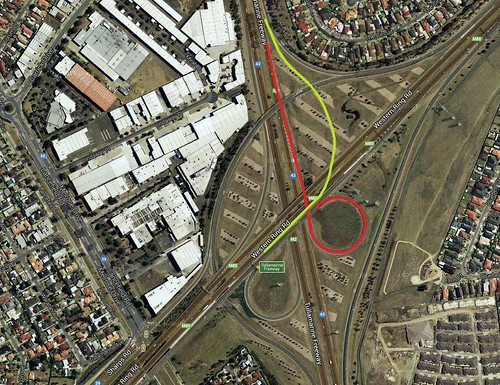
Freeway upgrades are the reason for the abandonment of another freeway ramp, this time at the interchange of the Western Ring Road and the Tullamarine Freeway. Opened in stages between 1992 and 1997, the interchange permits traffic to proceed in a number of directions with a mix of flyover and cloverleaf ramps. The most hair raising ramp in the interchange carried southbound traffic from the Tullamarine Freeway to the westbound Ring Road, negotiating a 270 degree turn that was restricted to just 40 km/h, before an immediate merge with Western Ring Road traffic headed for Melbourne Airport and Melrose Drive.
The end result was much lane weaving and an increased risk of collisions, so this congested section of the roadway was replaced as part of the M80 Ring Road upgrade project, which constructed a flyover ramp over the top of the entire interchange, opening to traffic in early 2013. The pavement remains in place.
2020 update – I missed one!
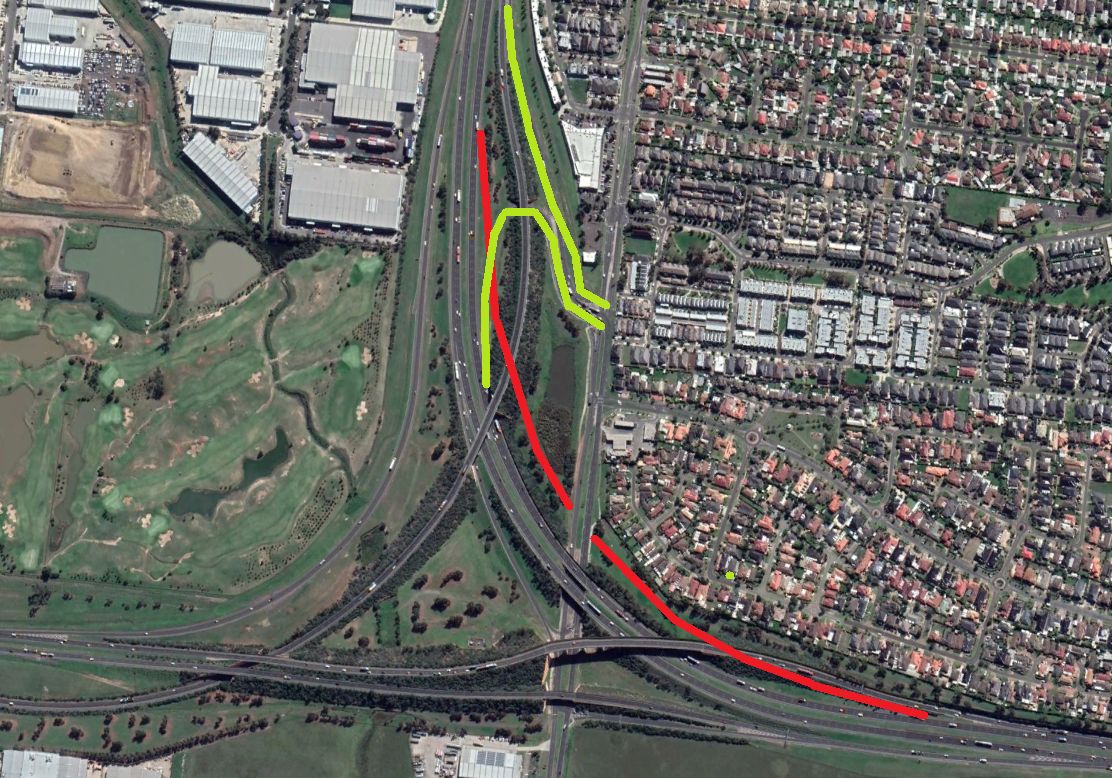
Over on Reddit, someone on r/melbourne pointed out a ghost ramp at the Frankston Freeway / Mornington Peninsula Freeway / EastLink / Peninsula Link interchange. This ramp originally formed the southbound carriageway from the Mornington Peninsula Freeway towards the Frankston Freeway, but replaced by the current ramp in 2012 to make way for the Peninsula Link – Mornington Peninsula Freeway bridge that passes over EastLink.
And another!
I drive past this one all the time – Fitzgerald Road interchange with the Western Ring Road and Deer Park Bypass. Originally constructed in the 1990s as a conventional diamond interchange, the addition of the Deer Park Bypass in 2009 saw the Fitzgerald Road ramps on the northern side of the interchange replaced by a new pair of sharply curved ramps further north, making space for the ramps carrying traffic between the Deer Park Bypass and the Western Ring Road, and eliminating possible weaving movements. The only trace today – some newer sections of kerb along Fitzgerald Road that replaced the former ramp connection.
And still more
The interchange of the Calder Freeway and Woorite Place was once a full diamond, but the ramps to the west were closed in the mid-1990s to make way for the nearby Western Ring Road interchange. The remains on the eastbound off ramp are still visible today at the interchange, but the outbound on ramp from Milleara Road was obliterated.

Not a freeway one, but still a ghost ramp: Kings Way southbound where the ramp from City Road joins it after it passes through Crown Casino has a little sliver of road that looks like it was supposed to be a ramp to somewhere but isn’t.
I believe the stub to nowhere is just an artifact of the road widening done for the additional ramps. IIRC both were just tacked onto the side of the bridge when the casino was built, to serve as the access to/from Whiteman Street and the multilevel carpark:
https://maps.google.com.au/maps?ll=-37.826002,144.960496&spn=0.0019,0.004128&hnear=Kings+Way,+Victoria&gl=au&t=h&z=19
Here is the road arrangement in 1966 – the Yarra Bank Road ramps were reused to access the car park, but there were never any ramps to/from the other direction:
http://melwayed1.melway.com.au/043.jpg
Sorry, by “City Road” I mean Whiteman Street. It’s _above_ City Road. Sigh.
From what I recall of the underside of King’s Way there, it looks like the ramps were added after the main bridge was built. (but still in the same “era”)
Your 1966 Melways map shows those ramps were still there back then. That said, it doesn’t show the loop under Kings Way just south of Whiteman Street which looks like it was added later – straight concrete columns instead of trapezoidal supports.
I’m guessing that, given the ’66 map and the tapering on the western side, there was originally intended to be either an extra south bound lane on King’s way or a slip ramp onto Grant Street or something like that, however that never happened, and when the loop and eventual carpark ramps were added, it didn’t get removed.
Unfortunately my Melway collection (!) only goes back to 2000:
http://www.flickr.com/photos/legoblock/sets/72157634964034483/
But my Gregory’s Melbourne Street Directory (14th Edition, 1982) only shows the same ramps as 1966 – time for some more digging.
Hi Julian, that King’s Way ramp shows up well on Google maps. when I get some spare time, I am going to go up there and take a closer look at it. I’ll post any pics I take naturally!!
[…] February 25 blog post on Melbourne
Another one is located on the Pakenham Bypass, just before Officer South road, not as clear inbound but is outbound with arrows signs included to prevent motorists from mistaken it for a operational off-ramp.
Not sure the story behind that, I thought it was part of the long term route for traffic to enter Koo-Wee-Rup road as seen here:
http://www.vicroads.vic.gov.au/Home/RoadProjects/PlanningAndProposals/Regional/KooWe+RupRdPakenhamToKooWeeRup.htm
But it’s on the wrong location, so I gather it most likely a future project for when the house estates continues west towards Officer South road which see a need for that road to be upgraded with access to the Freeway.
I’ve noticed those stubs on the Pakenham Bypass as well – Google Maps shows it as well:
https://maps.google.com.au/maps?ll=-38.074523,145.403752&spn=0.00554,0.008004&hnear=Pakenham+Bypass,+Victoria&gl=au&t=h&z=17
It appears an interchange will be going in soon, or at least a local property developer hopes it will:
http://timbertopestate.com.au/timbertop-estate/public-transport/
I drive on the eastern freeway every day and didn’t know there was a ghost ramp on the Chandler Highway exit. I will check it out.
China has ghost cities, we have ghost freeway ramps!
It’s pretty obvious once you know it is there – you can even see from the outbound carriageway.
The Chandler Highway (E6) also includes an wide overpass over the Eastern (F19) with additional room to the left inbound for the east-to-north ramp to form the opposite directional ramp to the one you have discussed. It is worth noting older Melway directories, including my 1975 one show the west-to-south ramp you have there dashed in!
Thanks for that. I’ve noticed the extra span on that side, but could never work out what ramp it was intended for – the Melway never showed it.
Where the Hume Freeway merges with the Metropolitan Ring road there is a partially complete ramp that I assume was to take westbound traffic (on the Ring road)north onto the Hume Freeway. It is an interesting relic that I discovered while working as a courier. I’m glad to see that the disused bridge over the Calder freeway is included in the list!!
Thanks for that Paul – I had it pointed out to me on Twitter some time ago, but I forget about it. Here is a view from the western side:
https://www.google.com/maps/@-37.688465,144.984521,3a,62.7y,41.41h,75.61t/data=!3m4!1e1!3m2!1sMGTWw6KBX1GFs3pyDNBnPg!2e0
Apparently the ramp was an anomaly in the design, with the current ramp being built instead.
Thanks for the web link, Marcus. I’ve been looking at some ghost ramps in the US. It just goes to show that they have everything bigger over there!! The sheer number of old ramps and stubs they have is remarkable! Some of the old ramps are quite extensive. Definitely one for my unofficial bucket list!!!
You’re right about how many ramp stubs exist in the US – there are far too many to count in this list!
http://en.wikipedia.org/wiki/List_of_unused_highways_in_the_United_States
Yes, two hours of searching the internet, and I finally found mention of it. Seriously, you build a ramp and never use it? I think though that if they had of used this ramp, then the Edgars Road entry would be to close to the Hume Freeway entry. But, this ghost ramp actually meshes well with the look of the interchange. Any further information?
Weaving between the Edgars Road and Hume Freeway might be one reason for the change.
Unfortunately the only reference to design changes I’ve been able to find is here:
https://web.archive.org/web/20160312011945/http://parkweb.vic.gov.au/__data/assets/pdf_file/0003/580503/merri_creek_parklands_plan_2013.pdf
The former road reserve is now the Cooper Street Grasslands – the original Craigieburn Bypass alignment would have crossed Merri Creek three times, destroying the habitat of the Growling Grass Frog.
Marcus, I found an interesting video on line at https://www.youtube.com/watch?v=xo7K7a34Q_0.
It focuses on the ghost ramps and stubs on freeways in Seattle, Washington. The video quality is very
good and reinforces what I said earlier: that they have everything bigger and better over there including ghost ramps!!
With reference to my last, the narrator isn’t Noel Coward so don’t expect too much!! But an interesting video nonetheless.
Marcus, there is a ghost ramp in Mt Eliza. Deviating to the left off Nepean Hwy(northbound)it originally allowed traffic to join Gillards Rd, and then Mt Eliza Way. The ramp is at Melway ref 101 G12 or 105 G1.
Thanks for that – even Google Maps shows the stub, but in a lighter colour:
https://www.google.com.au/maps/place/@-38.1810355,145.0950915,18z/data=!4m2!3m1!1s0x6ad6742754ab5729:0x5fa8f9b366d4e02a
The part of Gillards Road Mount Eliza to which you refer as a ghost ramp is actually the original road that joined to Gillards Road (East) on the other side of the Nepean Highway. The road was changed in configuration at the time that Nepean Highway became duplicated, requiring a diversion of the Gillards Road East to join Baden Powell Drive for the intersection with Nepean highway.
Love the info here. Just as interesting as the rail trails etc.
I’ve been fortunate enough to travel on all of the above before they were closed & the City Link – Church Street really was a tight one as well as the old Airport merge at Essendon Airport being a poor quality ramp.
I’ve headed of the ramps at the Western Ring Road / Tullamarine Freeway interchange catching out many people – when returning from the airport I’ve heard of Geelong bound drivers taking the ‘early’ exit and ending up at Pascoe Vale Road!
I’ve only got vague memories of the old Essendon Airport merge, and the entire freeway through that section was narrow and at the bottom of a cutting.
[…] Melbourne’s freeway ‘ghost ramps’ * […]
Reminds me of Glasgow and the M8 Motorway/Highway’s “ski jump”.
http://m8motorway.tripod.com/m8_glasgow_j20.htm
http://www.cbrd.co.uk/articles/glasgow/legacy.shtml#skijump
http://www.geograph.org.uk/photo/1096392
That ramp looks like something the Dukes of Hazzard would be driving over!
Hi.
Nice article. I was lead designer on the Tullamarine Calder project and the section of ramp you’ve mentioned in now use to provide maintenance vehicle access to the horn shaped area between the new freeway alignment and the North bound ramp. This area of reserve contains a rather large water main in a tunnel so keeping safe access for maintenance was crucial and having this bit of road left over was a bonus for us.
Oh and the ramp into the CityLink tunnel is also still used for emergency access and maintenance activities.
All the best,
David
Thanks for that extra info David.
Some ghosts come back to life, the Power Street on ramp mentioned in your article, and comments about it being retained for maintenance access has been temporary reopened while the Kings Way off ramp is closed due to the crane issues.
It is mentioned on their twitter account along with a photo.
https://twitter.com/citylinkmelb
The Kings Way ramp closed last Friday after the nearby crane was dislodged, but it took them until 1.30pm today to realise the old ramp was still there!
http://www.heraldsun.com.au/news/victoria/citylink-opens-new-ramp-to-help-ease-the-kings-way-crush/story-fni0fit3-1227480507816
i dont agree with closing it, if anything use those stop go lights or something, but to spend money on something and not use it? waste of money. also should have made citylink tunnels 3 lanes, what a bloody waste. id have just gone for above ground freeway. stupid tunnel hippies, i wonder what happens when the tunnel expires?
Originally you could get onto Citylink from Power Street Southbound, Kings Way Upper and Lower Southbound and Kings Way Northbound. If I recall correctly, Vicroads decided that all these options meant there was too much merging, (particularly people using the Westgate to go between Kings Way and Montague Street) so they reconfigured the Westgate Freeway moving exits around, (like the crazy Westgate Bridge to Kings Way ramp) reconfigured the entrances to Citylink from Kings Way so you couldn’t go from City Road to Kings Way and closed the power street on-ramp, by which I mean it was fenced off with a car-park barrier to prevent access except to Citylink vehicles.
It’s been there for as long as Citylink has, it was just closed due to Vicroads wanting to reduce merging.
I believe Citylink used tunnels because they either couldn’t obtain the land to do it above ground or couldn’t get enough. As far as I’m aware, tunnels cost a lot more than above ground roads. They wouldn’t have gone under the Yarra without an exceptionally good reason. (Crossing both St Kilda Road and the Botanical Gardens would have been practically impossible above ground)
As for when they “expire”, I guess they’ll be reconditioned or rebuilt.
they knew when they made the west gate freeway, that some form of expansion was on the cards, so they must have known that at some point they were going to need this space. old maps show a freeway reservation right? the problem to me was that the tunnels had their lifetime reduced. above ground freeway was fine above the river on the west end of melbourne, but oh noes, not some stupid botanical park that nobody ever uses. tunnels are dumb, they ensure that the road will always be tolled, whereas at some point a normal freeway will be free from tolls. paying for the preservation of a political power of the time. whos going to pay for new tunnels?
Just three days of use, and the Power Street ramp closes again:
https://twitter.com/CityLinkMelb/status/632097992145698816
There is also ghost ramps along the Princes Freeway, in Drouin, with the old Buln Buln Rd ramps closed off, which I believe is because the ramp comes down onto a steep hill, but I’m not quite sure
Google Maps link:
https://www.google.com.au/maps/place/Drouin+VIC+3818/@-38.1306612,145.8753254,643m/data=!3m1!1e3!4m2!3m1!1s0x6b29eaadadaf090f:0x40579a430a05d70?hl=en
The crossover between the two sides of the Princes Freeway south of Buln Buln Road make it look like these ramps date from when the freeway was not divided and (I’m guessing) the ramps serviced both directions. (It doesn’t look like there were ever ramps on the other side. That said, there’s a bump of asphalt opposite the northern ramp which might be the last remnant of a ramp on the northern corner of this intersection.)
I’m guessing when the freeway was upgraded, these were closed as there’s already a big interchange a couple of kilometres away to the south.
From what I can find in old copies of the Country Roads Board annual reports, the Drouin Bypass only every existed as the current dual carriageway:
http://www.parliament.vic.gov.au/papers/govpub/VPARL1981-82No44.pdf
It opened in December 1981, and ran from a point midway between Drouin and Warragul, near Lardner Track, to the existing highway just south of Old Sale Road:
http://mrv.ozroads.com.au/highway1/history.htm
The connections to the east and west came later, but neither was near Buln Buln Road.
I stand corrected.
Maybe this is now for emergency vehicles? (which would explain the crossover between the highway lanes)
Its definitely not for emergency, as there are signs saying NO ROAD right in the middle of the off ramp
I think they were used during the construction of the freeway so that vehicles could use Buln Buln Road to access the road while it was being built. The fact there is one on each side of the bridge further suggests this as construction workers and vehicles needed a way to cross the gap before the bridges were built. I’d say they were kept in place until work was completed and then closed off later
Hi Marcus,
Great site and in particular, a great post. The M80 / M31 realignment was a new one for me, so pretty chuffed to hear about it!
Not sure if this could be catagorised as a stub but there is certainly provision for ramps on the M1 at Huntingdale Rd here: https://www.google.com.au/maps/@-37.8865352,145.106798,193m/data=!3m1!1e3
You can also see former alignments of the M8 on Google too: https://www.google.com.au/maps/@-37.685074,144.4848422,475m/data=!3m1!1e3
Finally, I have an Edition 11 Melway from 1978 in my collection that notes a Southbound NR-1 ramp onto the Princes Freeway here: https://www.google.com.au/maps/@-37.8534199,144.7789743,628m/data=!3m1!1e3 but there is nothing at ground level suggesting it so am unsure whether it was a publishing error or what.
Cheers.
Huntingdale Road is an interesting one – it appears that the lack of ramps is due to the Mulgrave Freeway being built in stages. From here:
http://mrv.ozroads.com.au/highway1/monash/monash_history.htm
– The following stages of freeway went west to Springvale Road (December 1973), Blackburn Road (15 December 1976), Forster Rd (5 April 1977), Huntingdale Rd (12 December 1979) and finally to Warrigal Road on 24 June 1981
Westbound ramps at Huntingdale Road made little sense for a freeway that terminated at the next interchange. It took until 1988 for the link to the city to be completed, and only as an arterial road, so going back to Huntingdale Road and adding the extra ramps presumably fell off the agenda.
I’m surprised I missed the ramps at Bacchus Marsh – I took plenty of photos of the Anthony’s Cutting realignment works during 2010-11:
https://www.flickr.com/photos/legoblock/sets/72157627112857876
Excellent pics, good to see the underside of the Pykes Creek bridge post barrier upgrade. I wasn’t sure what had happened there but can now see the original spans remain.
As for the Prices Freeway at Laverton, there used to be a subway at Kororoit Creek Road to allow explosives trucks travelling between Deer Park and Altona to avoid an at-grade crossing:
http://mrv.ozroads.net.au/southwest/M1princes/history.htm#m1
Ah yes, nothing to see there now but those bridges were noted in that same, early Melway.
This is irrelevant to your post as it concerns Sydney but I’m wondering if you’ve ever encountered the mother of all Australian ghost ramps beneath the Western Distributor: https://www.google.com.au/maps/@-33.8664061,151.2033586,3a,75y,47.49h,90t/data=!3m6!1e1!3m4!1s_Pw0IdujgJ6ZTgQfdSo0Pg!2e0!7i13312!8i6656
M31 newly built ghost ramp?
https://www.google.com.au/maps/@-36.1102141,146.8971883,155m/data=!3m1!1e3
When the Albury Bypass first opened, the Murray Valley Highway didn’t have any westbound ramps to the Hume Freeway, due to the railway being in the way. After the Wodonga Rail Bypass was opened, the old railway was removed and the Bandiana Link Road was opened, leaving the old High Street on-ramp behind.
http://www.bordermail.com.au/story/59227/hume-link-taking-shape/
It looks like there was meant to be an overpass at Sunshine avenue intersecting with the calder freeway as the dirt mounds are there and have been there ever since I can remember. Not sure when this section was completed and if they ran out of money at the time.
From memory, this section of the Calder Freeway opened in the late 80’s with the divided road ending just north of Sunshine Avenue. The road was duplicated in the early 90’s, but the flyover mounds that seemingly provided for a southbound exit from the Freeway onto Sunshine Avenue indeed never came to fruition. I imagine now the Kings Road interchange has been built, the Sunshine Avenue/Calder Freeway ramps will never see the light of day.
It’s less than two kilometres between Sunshine Avenue and Kings Road, so the justification for building the ramps is doubtful.
Back in 2011 it was decided to close the median openings along that station of freeway, and convert the existing outbound entry from Sunshine Avenue into a freeway standard ramp, for a cost of $1.7 million:
http://web.archive.org/web/20150301082330/http://calderactiongroup.com.au/documents/PDF/Correspondence_In/Correspondence_In_Sunshine%20Ave%20Fact%20Sheet%20VicRoads.pdf
The Mornington Peninsular Freeway from Jetty Road to Boneo Road in Rosebud was an extension built by the local council. It was built along the Freeway reserve but only included what would be the Portsea bound lanes of the Freeway. This was done to assist the State Government in constructing the Freeway past the end at Jetty Road. The council did this to take traffic off Eastbourne Road, that was being used to get to the Boneo Road end of Rosebud and to the TAFE and Bunnings on Boneo .
Though it is marked in the Melway as part of the Mornington Peninsular Freeway it is really just a council road built where the freeway will go.
Thanks for that extra info Andrew.
Do you know when this section was originally opened to traffic? Can’t seem to find a date anywhere.
Hi Marcus, nice photos of Anthony’s Cutting, what are your thoughts on the geelong ring road, and was the traffic in geelong really bad before then?, also are they planning on building future ramps for broderick road since they had some originally?
Lots of the traffic using LaTrobe Terrace in Geelong was internal traffic, so building the ring road didn’t make much difference – nobody is going to drive out of Geelong than back in again.
The main advantage was to people heading from Melbourne to towns south of Geelong:
https://geelongindy.com.au/indy/2009-10-29/bypass-set-for-holiday-snarls/
But it has also made large parts of Geelong more accessible to Melbourne commuters, turning them into new car-based dormitory suburbs:
https://www.ptua.org.au/myths/bypass/
As for ramps at Broderick Road, the G21 Geelong Region Alliance has it on their wishlist:
http://www.g21.com.au/geelong-ring-road-connections
But there isn’t any land reserved for said ramps:
https://wongm.com/wp-content/uploads/2016/06/New-Station-Estate-Broderick-Road-corio-land-victoria.jpg
The initial stub built in the early 2000s to link the Corio Interchange to Broderick Road was just two lanes, and ended at a ‘T’ intersection:
http://www.expressway.online/library/vic/pdfs/geelong_rd_corio.pdf
Another disused section of freeway is the section of pavement that used to form the citybound carriageway of the Princess Highway/Freeway in Nar Nar Goon. This pavement became redundant when the Pakenham Bypass opened and the Warragul bound carriageway was converted into a 2 lane road to extend Bessie Creek Road to the highway. A portion of the disused pavement is currently used by VicRoads for storage of gravel and was also rented for 12 months for crash testing road safety equipment. This section of road was also lucky enough to have street view images taken from when it was still in use.
Westbound carriageway at Nar Nar Goon Connection Road in November 2007.
https://www.google.com/maps/@-38.0681004,145.5599631,3a,75y,101.19h,91.61t/data=!3m6!1e1!3m4!1ss6PglAOQeNVjkNk5Ooa62A!2e0!7i3328!8i1664
And today.
https://www.google.com/maps/@-38.0680894,145.5598528,3a,15y,98.79h,90.53t/data=!3m6!1e1!3m4!1sflFdHZ-ikcE_KN1Y-tnZXw!2e0!7i16384!8i8192
It looks like that that point the Pakenham Bypass was already open – this is the diverge.
https://www.google.com/maps/@-38.0693806,145.571552,3a,75y,307.97h,96.27t/data=!3m6!1e1!3m4!1sbV8GC5lX7vynnkJpGJ2MWA!2e0!7i3328!8i1664
There’s another ghost ramp at the Bell Street interchange. It became redundant when the Citylink-Tulla Widening Project was completed
Cheers – you can see the stub in this April 2019 Google Street View image.
https://www.google.com/maps/@-37.7363145,144.9285063,3a,75y,292.86h,80.97t/data=!3m7!1e1!3m5!1sSERJNGA1wsd8QRPM05hgKw!2e0!5s20190401T000000!7i16384!8i8192
The freeway upgrade project saw traffic from Bell Street to Pascoe Vale Road diverted onto a new bridge, removing a right hand merge, but almost passing over the top of a neighbouring school.
https://www.theage.com.au/national/victoria/strathmore-school-says-citylink-tulla-project-a-risk-to-health-and-safety-20160205-gmn4z3.html
They are currently rebuilding the ramp at Police Road. I guess this ramp has risen from the dead
Interesting – from the Monash Freeway Upgrade website.
https://engage.vic.gov.au/jacksons-police-roads
“Police Road will be connected to the Monash Freeway by reinstating the outbound entry ramp and the existing Jacksons Road outbound entry ramp will be connected directly to EastLink with a new separated road.”
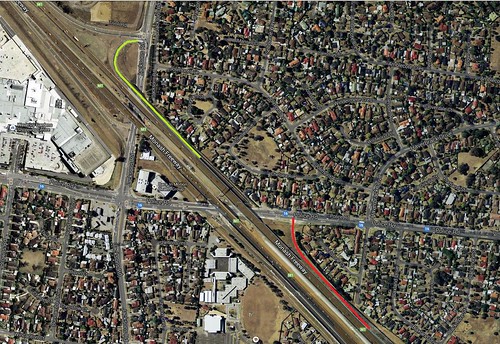
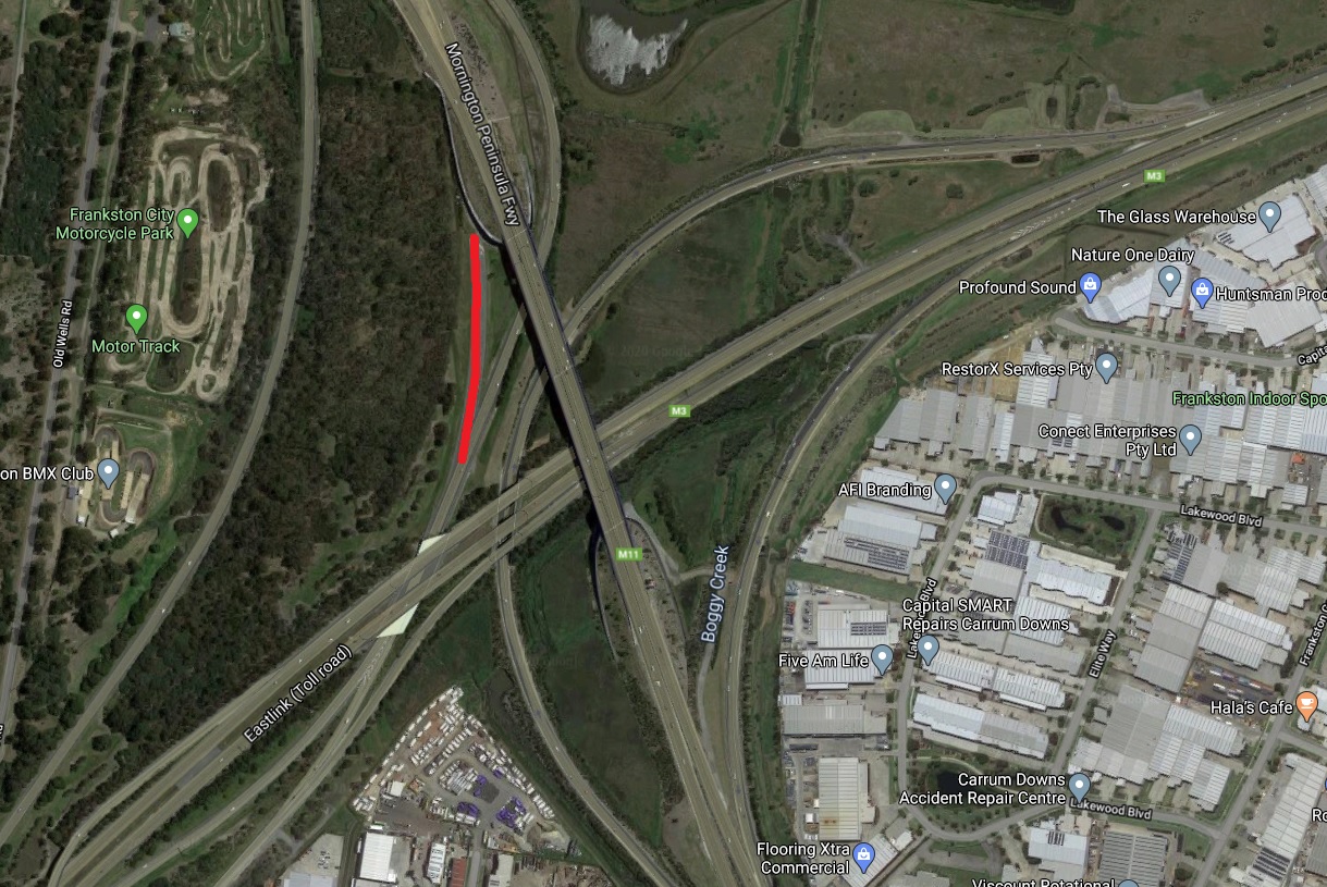
There’s a ghost ramp at the M11/M3 interchange in Seaford. It became redundant when the Peninsula Link was opened and the ramp was relocated to make room for the new bridge.
This one?
Yes
Just found this page, really fascinating stuff as an American. Always had a fascination with ghost ramps. I’ve discovered it’s not just highways that have ghosts roads, rural areas near me have them too. There’s lanes that lead to a partially completed median-entrance-exit near where I live that just dead ends by some grass near a subdivision. I asked on a Facebook group what the deal was with that, and someone told me there were originally plans to build a strip mall there but once it was discovered that the area was all wetlands and therefore unsuitable for any kind of construction they just abandoned the project and now there’s a half finished entrance/exit with grass growing over the median that still has a no-right-turn sign right before it: https://www.google.com/maps/@42.4683766,-87.8822768,3a,75y,90t/data=!3m6!1e1!3m4!1s_6JxZi5mAsYDz1DBPApwGw!2e0!7i16384!8i8192
There’s also one road a few miles from me that my school bus took me past every day on the route back home that’s now blocked by concrete barriers and had it’s street sign and Dead End sign taken down(the last photos I can find of them intact are from 2007). Got curious about that one too and I found out that the nearby private-airport forced the few people that lived there to move out so they could expand the airport but it’s been over a decade since that road was blocked off and there’s still been no expansion: https://www.google.com/maps/@42.4121191,-87.8780871,3a,75y,270h,90t/data=!3m6!1e1!3m4!1s8Kh1eTsf2NhpQh4R_O8wSA!2e0!7i16384!8i8192
The U.S. definitely does do things bigger, the most fascinating ghost ramps for me is this partially finished four-lane highway stack in Farmington, Connecticut: https://www.ctmq.org/ghost-highway-ramps/
Thanks for the links, especially that massive interchange in Connecticut!
My first introduction to ghost ramps online was mostly interchanges in the USA, the ones at home fly under the radar since they’re far smaller.
Here are some I have seen on Google Maps
– Corner of Mordalloc Freeway and Mornington Penninsula Freeway
– Corner of Western Freeway and Old Western Highway
– An entire ghost road, corner of Old Hume Highway and Egan Road, Glenrowan
– (In Brisbane) Corner of Souther Cross Way and Gateway Motorway in Banyo
The transition between the original highway alignments and the replacement freeway bypasses is a topic I’ve been meaning to cover.
NSW Roads & Maritime Services has covered the Old Hume Highway in some detail.
https://oldhumehwy.transport.nsw.gov.au/old-hume-hwy-history.html
https://www.transport.nsw.gov.au/system/files/media/documents/2023/history-begins-with-a-road.pdf
You got one on the EastLink-PenLink-Peninsula Freeway interchange, but missed the other. Just between the Rutherford Rd on/off ramps. Located at -38.0973661865403, 145.14688470320243.
Thanks for the tip – I went back in time on Google Earth and the March 2006 view shows the original setup, with just an exit ramp from the Mornington Peninsula Freeway. The current setup was created following the completion of EastLink.