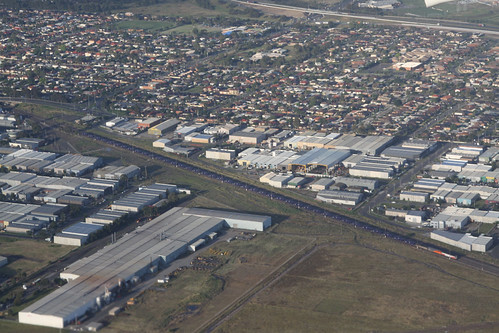
Melbourne is an ever growing city, but only 10 kilometres from the CBD lies a curious grid of abandoned roads, in the industrial backblocks of Sunshine North.
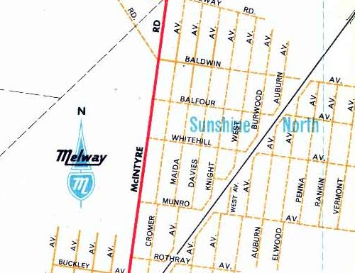
The grid of proposed roads can be found in Melway Edition 1 on map 26 and 27.
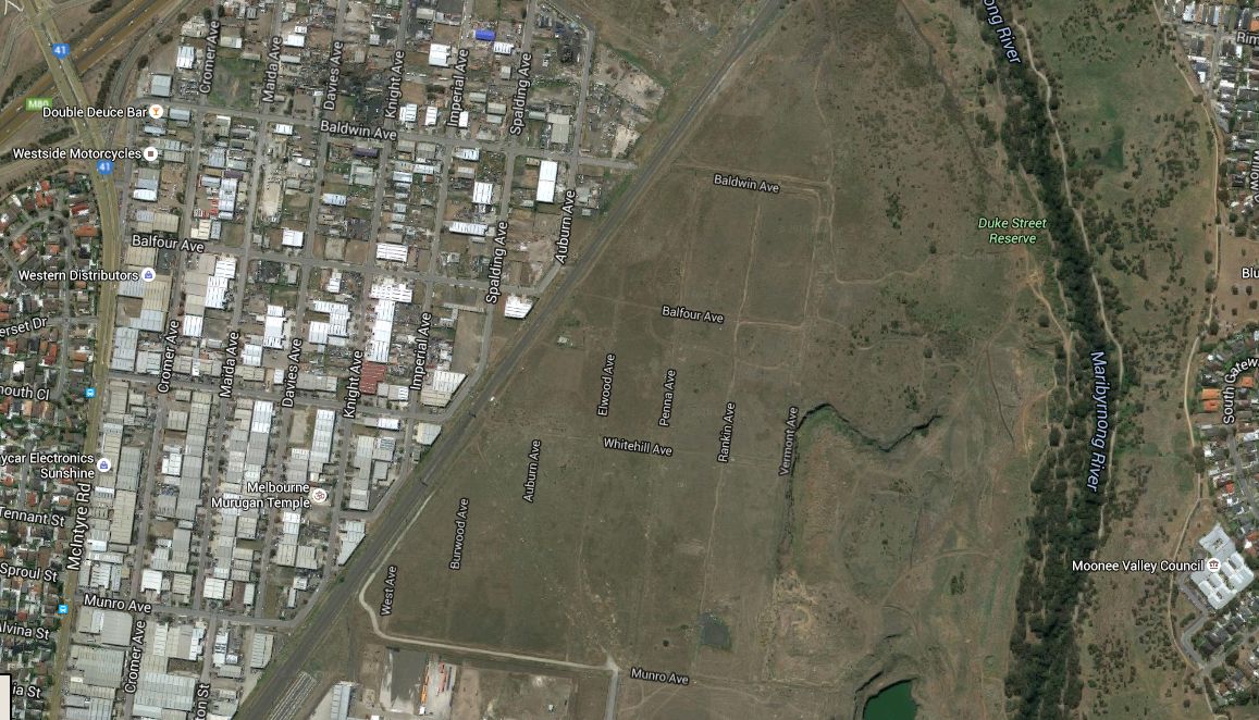
In the decades since the land on the western side of the railway line has been developed, but the other side lays empty – aerial imagery from Google Maps shows a grid of dirt tracks.
So why has such a large subdivision sit empty for so long?
I found the answer earlier this year, when a paper titled “Solomon Heights: A Zombie Subdivision?” was published. From the abstract:
Solomon Heights, 10kms west of the centre of Melbourne, Australia, on what has now become prime riverside real estate, is a case in point. Although subdivided into a residential pattern during the 1920s, the site had been rezoned industrial in the mid-1950s under Melbourne’s first comprehensive city plan. It was thereafter left fallow, for reasons unclear, without basic urban services like water or sealed roads. Environmental social issues have since come to impact on the site, while landowners seek the opportunity to build.
The rest of the paper is well worth the read, as are these other links:
- Solomon Heights: A Zombie Subdivision? (Elizabeth Taylor, David Nichols, Victoria Kolankiewicz)
- Solomon Heights at Brimbank City Council
- Solomon Heights at Wikipedia
Other abandoned subdivisions
Turns out the list of abandoned subdivisions in Victoria is quite long – so many that I’ve spun them off into their own articles.
As well as an overarching post covering the subject of ‘old and inappropriate subdivisions’ in Victoria.

Another ghost subdivision is on the Southern boundary of Essendon Airport where there is a ‘First Avenue’ which was part of a series of streets intended to go north to Seventh Avenue – expansion of the airport land from its original 1921 parcel in 1935 and again in 1943 saw only First and a short section of Second ever built – with the latter now part of the Tullamarine Freeway. Expansion of the airport can be seen below
http://www.airwaysmuseum.com/EN%20development%201.htm
The freeway also removed Hood Street and its houses either side from existence between Pascoe Vale Road and Napier Street hence the wide road reserve in that section.
It is not unusual for a cadastral plan and streets to be laid out in a country town much more substantially than was ever built. Working on a flood study in Port Albert in South Gippsland the digital data shows properties and streets on the eastern side of town which has only ever been swamp, with more never-developed lots on the western and north eastern edges of town. A 45° change in direction for Gibson Street at Lawrence Street is the only tangible reminder of where the town’s long-forgotten railway terminus was located.
Another interesting layout is in Lorne where I was also involved in some consulting work some years back – we were informed the layout of the original part of town was prepared in England with little thought to the steep terrain of the town site back from the water.
Nice find on Essendon Airport – the northern and eastern edges were actually reserved for the Tullamarine Freeway “escarpment route” that was never built:
http://www.theage.com.au/victoria/vicroads-offloads-fields-of-dreams-20130419-2i5ph.html
I ought to finish off that incomplete blog post sometime…
It’s a pity the Land Victoria interface for cadastral plans (http://services.land.vic.gov.au/landchannel/jsp/map/InteractiveMapIntro.jsp) is so painful compared to Google Maps – there would be plenty more examples to find.
You can find any number of ghostly towns in rural Victoria where a town was surveyed, but never developed. Here’s one at Galah:
https://www.google.com.au/maps/@-35.0834755,142.173516,17z
(zoom in until you can see the title boundaries). In this case, the streets have tracks along them, but in other cases it’s all just paddock.
Nice find there!
Having now read the paper you’ve linked to on Solomon Heights, it’s only unusual in *still* being undeveloped.
The great Melbourne land boom of the 1880s (and crash in the 1890s) left a multitude of such zombie subdivisions. Some had a few houses doted around dirt tracks. Most were eventually developed in the 1920s – 30 to 40 years later. If you’ve got an eye for house styles you can easily pick them. There will be a very small number of Victorian houses surrounded by houses from the twenties and later. Have a look at this example of two lower middle class Victorian cottages in Ormond surrounded by much later building stock:
https://www.google.com.au/maps/@-37.9049267,145.0334394,3a,75y,90t/data=!3m6!1e1!3m4!1swht342FLPl0tlXUPpRinzw!2e0!7i13312!8i6656
It was still happening in the ’20s. The VC Estate in McLeod (https://www.google.com.au/maps/@-37.7271281,145.0646721,17z) was subdivided in the ’20s – the streets are all named after WWI VC winners. It remained essentially barren of houses (or services) until the ’50s and ’60s when the suburban sprawl caught up with it.
Benjamin Street in Sunshine is another example of a slow to develop subdivision:
https://www.google.com.au/maps/@-37.7936128,144.8320127,3a,60y,181.58h,82.14t/data=!3m6!1e1!3m4!1sqBBoIVJ9Oe5TbBtmmIBqwA!2e0!7i13312!8i6656
The terrace houses pictured were built in the 1890s, but it took until the 1920s for the rest of the estate to develop, with the last blocks not being filled until the 1950s.
http://www.brimbank.vic.gov.au/files/20062dc9-a5a9-499d-aad1-9f040090b4bf/HO25_-_Railway_Station_Estate.pdf
There was a particularly interesting “zombie subdivision” on Sandstone Island in Western Port, which you can see at http://planning-schemes.delwp.vic.gov.au/__data/assets/pdf_file/0006/179232/frenchisland06zn.pdf . It laid out a completely inappropriate level of development for an island surrounded by tidal mud flats. Titles to the lots were never sold, and I also remember reading that the subdivision had been abolished, but I can’t find any evidence that that has happened.
By the sounds of it Sandstone Island is now owned by a syndicate:
http://www.domain.com.au/news/two-western-port-bay-islands-for-sale-20151221-glr4j6/
Not far off topic my old secondary school took up a few streets in an estate that would have otherwise been built.
An infill estate along the Mulgrave Freeway near Police Road was built in the mid 1980s around 10 years after the surrounding streets to the west, north and south. The 1984 Melway shows it dotted in formed by completing Manning Drive and Shelton Crescent on Map 80 K6/7
https://digitised-collections.unimelb.edu.au/bitstream/handle/11343/23965/306057_UDS2013221-9-0111-wm.jpg?sequence=111
Manning Drive and Keech Close were built but Nazareth College took up the remainder opening in 1986. A short section of Shelton Crescent was built now serving as the school entrance …
https://www.google.com.au/maps/@-37.9413563,145.1961372,3a,75y,13.5h,82.46t/data=!3m6!1e1!3m4!1sT2uVIQz10STPH29V-GemsQ!2e0!7i13312!8i6656?hl=en
At the back the mid 70’s sections of Shelton Crescent and Linda Road (now ‘Court’)still end abruptly ready to be completed …
https://www.google.com.au/maps/@-37.9385836,145.1946095,3a,75y,112.85h,78.35t/data=!3m6!1e1!3m4!1sAJNwsozrsxNOstZIzF2jnA!2e0!7i13312!8i6656?hl=en
The park on Linda Road remained jutting into the school site as per the original plan until the school eventually bought the parcel from Greater Dandenong Council to build a hall/gymnasium
Quite a curious arrangement – and not apparent unless you grew up there, or spend hours playing “spot the difference” in the Melways.
Another from my part of the world was Hansworth Street next to Waverley Gardens Shopping Centre which opened its first stage in 1977 and second in 1981. A short section of Hansworth Street was missing for the reason that it was originally part of VFL Park but was cut off soon after when Stage 2 of the Mulgrave Freeway was built through
The original site (Map 80 H4) …
http://melwayed1.melway.com.au/080.jpg
Cut off by the freeway construction around 1971
https://digitised-collections.unimelb.edu.au/bitstream/handle/11343/23961/302583_UDS2012032-5-0089-wm.jpg?sequence=89
Freeway with the Hansworth Street dotted in never to be built. As I hear the residents were quite happy not to have shopping centre traffic pass through so it was never completed.
https://digitised-collections.unimelb.edu.au/bitstream/handle/11343/23964/305380_UDS2013221-8-0109-wm.jpg?sequence=109
After decades of remaining vacant the site eventually became an Aged Care facility.
[…] first zombie subdivisions I found was Solomon Heights in Sunshine North – subdivided for residential purposes but related rezoned as […]
I found some in my council area:
https://planning-schemes.app.planning.vic.gov.au/MOORABOOL/ordinance/45.05-s-1.0
What do you make of these Marcus?
They’re another example of “old and inappropriate subdivisions” – I’ve written about examples elsewhere here:
https://wongm.com/2020/05/old-and-inappropriate-subdivisions-of-victoria/
For the ones in Moorabool, where is a map for the one in Elaine North – in the middle of nowhere:
https://planning-schemes.app.planning.vic.gov.au/static/maps/C107moor/moor/moorabool50ro.pdf
Wallace, beside the freeway.
https://planning-schemes.app.planning.vic.gov.au/static/maps/C107moor/moor/moorabool11ro.pdf
The township of Rowsley:
https://planning-schemes.app.planning.vic.gov.au/static/maps/C107moor/moor/moorabool45ro.pdf
And in the forest at Blakeville.
https://planning-schemes.app.planning.vic.gov.au/static/maps/C107moor/moor/moorabool14ro.pdf
That was a quick response, thank you. Why are they still in place after such a long time, if there’s no plans to implement them? How do you find out when they were introduced?
I suspect it’s a case of:
– area was subdivided decades ago, before town planing was a thing
– since the, council has decided that the area is not suitable for closer development
– and so the subdivisions have had a restructure overlay applied so that the blocks of land are not built upon unless consolidated with neighbouring properties
One of the other concerns with these small blocks in unsewered is that they’re too small for a septic tank to be installed.