As a kid growing up in Geelong during the 1990s, driving up the Princes Freeway to Melbourne was a regular occurrence. Back then empty paddocks were a common sight, but today they are all gone except for one – a paddock between Kororoit Creek Road and the Laverton railway bridge.

Exploring the paddock
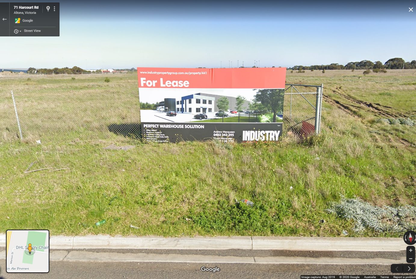
The bulk of the land is open grasslands, but back in 2010 one landowner had fenced off their little portion.

And by 2019 they were planning to build a warehouse on the site.
Other landowners were trying to sell their slice.

One vendor selling multiple blocks.

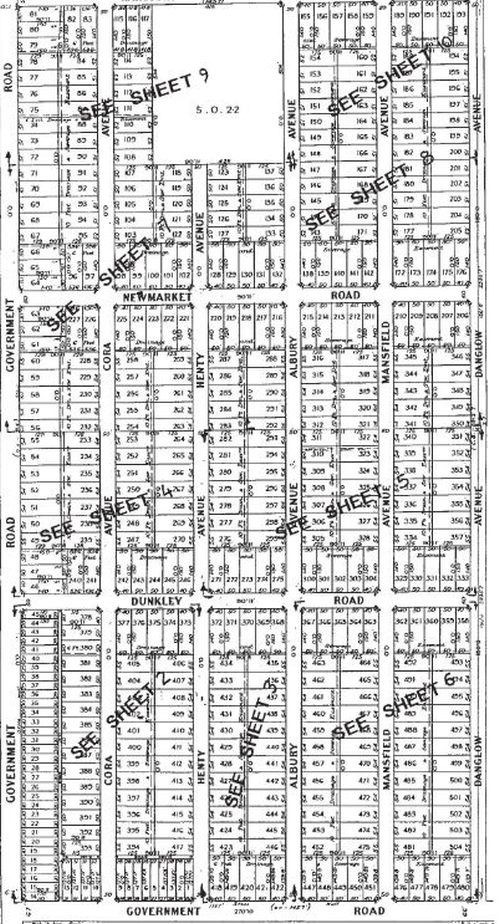
But the strangest were these two blocks of land located on a non-existent road – ‘Danglow Avenue’.

Doing some digging
When I headed over to Google Maps, a grid of tiny blocks of land appeared.

With the state government Land Channel maps showing the same.

Including a larger block of land zoned for public parkland.

So why was the estate never developed, unlike the industrial complexes that now surround it?

And the answer
Hobsons Bay City Council has a page on what is called the ‘Burns Road Industrial Estate‘.
The Burns Road Industrial Estate is located between the State Baseball Softball Centre, Harcourt Road and Merton Street in Altona. It has 505 lots owned by over 170 property owners. The estate was subdivided in the 1920s. No roads, drains or other services have ever physically been created. The estate has remained undeveloped for almost 100 years due to a range of complex issues, including lot size and configuration, native vegetation, and the complexities of the multiple ownerships.
Including a detailed history of the estate.
1929: The Burns Road Estate was subdivided for the purpose of residential development, with the site set aside as a reserve to be used for private recreation to serve the residential lots. Although the site was identified for the purposes of public open space, it was not vested into Council’s name as part of the original subdivision.
Mid 1950s: The Estate was zoned ‘Rural’ (east of Henty Avenue) and Explosive Buffer Zone (west of Henty Avenue). The Melbourne and Metropolitan Board of Works also placed an Interim Development Order (IDO) on the Estate and detached houses were permitted provided the site was five acres (two hectares). Industrial development was prohibited.
1960s: The Explosive Buffer Zone was replaced with the Rural Zone. From the late 1960s to the mid 1970s the minimum land requirements to construct a detached house were reduced to 3.5 acres (1.4 hectares) and industry and light industry were allowed subject to a planning permit.
1976: The land was rezoned to Reserved Light Industrial where light industry and detached houses were allowed (no conditions were attached).
1986: The Minister for Planning and Environment applied an IDO over and around the Altona Petrochemical Complex. This was followed by Amendment 404 to the Altona Planning Scheme.
1988: The new Altona Planning Scheme was introduced and detached housing was prohibited. The land at 18‐71 Harcourt Road, Altona was included as Public Open Space.
1993: Employee Population Density Controls were introduced to the Altona Planning Scheme to protect the State’s petrochemical industry and minimise the risk to personal safety from a major petrochemical accident.
1997: Given the long and complex history with the Estate, the Council engaged Ratio Consultants to prepare the Burns Road Industrial Estate Structure Plan. The Structure Plan, which was not adopted, recommended:
– A restructure of the subdivision to a minimum lot size of two hectares (which was based on the 1997 development market for industrial lots);
– Minimum road pavement of 10.2 metres for all internal roads and 20 metres for periphery roads; and
– Implementation facilitated by establishing a unit trust, whereby landowners register their lots with the trust which then offers the land.2000: The New Format Planning Scheme was introduced and the Estate was zoned SUZ4 which specifies a minimum lot size of two hectares for development of this land and contains the Employee Population Density Controls.
2002: The Council began preparing the Industrial Land Management Strategy (ILMS) which was introduced into the planning scheme as a reference document via Amendment C33.
2008: Amendment C33 was approved by the Minister for Planning. The Estate forms part of Precinct 1 – Burns Road, Altona, which is identified as ‘Core Industrial’ in the ILMS reference document. A key strategic action/objective for this Precinct is to support its role as Core Industrial.
2011‐12: The Council undertook a policy neutral review of the Municipal Strategic Statement as part of Amendment C63. The Panel Report for Amendment C63 recommended that the
Council add under Further Strategic work in Clause 21.07 Economic Development, ‘review the planning framework for the Burns Road Estate area in Altona to determine the appropriate policy zoning, and overlays to address long standing use and development issues’2013: Council adopted this recommendation and resolved to undertake a feasibility study for the Estate.
The most recent review was triggered by a group of irate landowners.
A group of up to 200 landholders, spearheaded by Laverton North business owner Michael Sergi, believe the council has not helped them make something of their investment.
Mr Sergi said the council had been “stealing rates” and had “failed the people of Altona”.
“In 1997, the council commissioned Ratio planning and development consultants to produce a structure plan for the Burns Road industrial estate,” he said.
“The report recommended a ‘unit trust’ scheme where individual lots would be pooled to form a minimum two hectares for development.
“The report was presented to landowners in July 2004 and promptly shelved. Why has Hobsons Bay not acted on the report of the consultants it has contracted?”
As the Weekly exclusively reported last September, Mr Sergi hopes to form a consortium and build a truck wash on the 40-hectare estate, which was rezoned light industrial in 1954.
To date, he has spent more than $1 million battling the council without progressing his plans.
In 2014 a consultant was engaged to negotiate a settlement between landowners, leading to the creation of the Burns Road Landowners Group in 2017.
Membership of the group had risen to 46 by August 2018, representing 230 of the 505 lots in the estate, while at the same time a group of five landowners rationalised their nearly 100 lots into less and more logical parcels.
100 years after the initial subdivision of the estate, it appears that development might finally be going ahead!
Further reading
And a Princes Freeway footnote
A short distance on the other side of Kororoit Creek Road is another seemingly empty paddock.

Located in the triangle between the Princes Freeway and a car storage yard.

That’s the Laverton North Grasslands – 40 hectares of land reserved in the 1980s to preserve one of the few remaining grasslands in western Melbourne.

It may well have been the Great Depression and WWII rendering housing construction almost non-existent that prevented this subdivision from starting development before planning controls stopped it.
Had it been developed for residential purposes then, there may have been greater pressure for earler suburban service on the Werribee line/ more patronage to maintain services on the direct line.
Laverton was the site of another speculative housing estate in the 1880s:
https://wyndhamhistory.net.au/items/show/1050
But it wasn’t until the 1960s for real development to start – the Housing Commission estate.
https://www.victorianplaces.com.au/laverton
On a side note, the current Princes Freeway alignment wasn’t built until 1939:
https://www.railgeelong.com/location/princes-freeway-laverton/
There is high conservation value with remnant grassland considered highly endangered on a federal level. Surely if the natural value is preserved and enhanced, It could be sold as conservation area. Maybe to the federal government?
Plus the traffic in the area is very congested already and conservation area wouldnt add to it.
Grasslands west of Melbourne are supposed to be protected as the Western Grassland Reserves, but the government hasn’t been funding them.
https://vnpa.org.au/the-broken-promised-grasslands-of-melbourne/
I noticed once on an old Melbourne street directory that there was a Southbound on-ramp from Merton Street, just South of the gazetted Dunkley Rd to the Princes Freeway but have never been able to substantiate it.
Interesting – I wonder it was related to the ‘Explosives Road’ that linked Laverton to Deer Park:
https://wongm.com/2011/05/raaf-williams-air-force-base/#comment-41495
I suspect the Explosives Rd / Merton St on-ramp was designed to act as a south-bound freeway access point for all Kororoit Creek Rd and Fitzgerald are traffic, as the interchange of those roads with the freeway didn’t have its own south-bound ramp in those days.
[…] similar example is the ‘Burns Road Estate‘ in Altona – subdivided in the 1920s, but never […]
[…] Burns Road Estate in Altona […]