This is the tale of Rosedale Estate in Chartwell, a failed subdivision on the western plains of Melbourne, midway between Werribee and Rockbank.
Early years
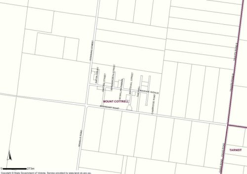
The neat grid of streets stand out against the flat grasslands, 7 km south of Rockbank and 10 km north of Werribee.
All with British names:
- Downing Street,
- Mayfair Avenue,
- Eaton Court,
- Oxford Street,
- Shelly Court,
- Wandsworth Street,
- McMillan Parade,
- Finchley Court,
- The Mall,
- Sheridan Close,
- Stratford Road
Volume 2 – The Environmental Thematic History from the Shire of Melton Heritage Study by David Moloney explains how the estate came to be:
Rosedale Estate, Chartwell (commonly known as the ‘Chartwell Estate’) was a 1957 subdivision of 491 township sized allotments situated on the eastern corner of Boundary Road and Downing Street (Crown Allotment 5, Section 4, Parish of Pywheitjorrk).
The English mansion Chartwell, best known for its twentieth century ownership by Sir Winston Churchill, overlooks ‘The Weald of Kent’: a rolling green woodland. If the name Chartwell was meant to inspire images of such British landscapes, the Melton South Chartwell – isolated, flat, dry, and totally devoid of trees – was a grand fraud. The Estate’s street names – The Mall, Oxford Street, Downing Street, Mayfair Avenue, Eaton Court, Wandsworth Street, Stratford Street, Macmillan Parade, and Finchley Court – seem to be intended to inspire rich images of England. Most are famous English streets or places; others, including Macmillan Parade (probably named after Harold Macmillan, the English Prime Minister who assumed office in 1957), had more contemporary associations.
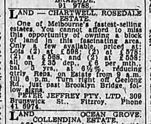
The original subdividers, an English couple, went bankrupt before selling the entire estate, which was then taken over by a real estate company. The estate was marketed to new English migrants in western suburbs migrant hostels, many of whom purchased their allotment ‘site unseen’ on the basis of the estate’s proximity to Melbourne, and affordability.
An example of these advertisements is this from 1964.
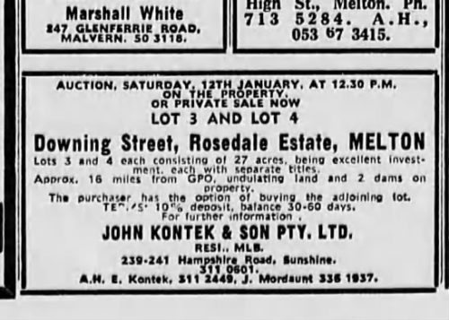
With land still on sale a decade later.
The land being zoned residential as late as 1985.
Development pains
The 491 lot estate could have housed 1500 people, but the land wasn’t suitable for development:
The original approval of the estate in 1957 had apparently been an oversight on the part of a Council which at that time had little experience with legal processes for residential subdivision. The estate did not have water and, more significantly, sewerage; the high rock bedrock of the district would not accommodate 491 septic tanks.
Following the introduction of the Melbourne Metropolitan Interim Development Order (Extension Area No. 1) in 1971, the Melbourne and Metropolitan Board of Works refused 18 applications for detached houses in the Rosedale Estate, with the Town Planning Appeals Tribunal hearing three appeals.
In 1976 the subject of development was revisited by Earle and Partners, as part of their Melton-Sunbury Peripheral Towns Study for the Melton-Sunbury Interim Co-ordinating Committee:
We recommend that no public effort be made to improve the services of water or sewerage to Chartwell and that any further building be subject to satisfactory sewerage, drainage and water being provided on the site.
It is expected that this will require a degree of site amalgamation and could result in a total population of 300-400 people.
Existing residents were against further development:
The Board received a letter signed by ten residents on November 16, 1977 stating that they considered that ‘any further development would create unbearable living conditions for those already living on the estate’. The letter noted the problem of roads being ‘impassable for long periods during wet weather’, and the general lack of facilities. The residents were particularly concerned about the lack of sewerage and drainage and believe that a health hazard will result if further development occurs.
But in 1977 the Board’s Planning Committee resolved that the area had been accepted for ultimate development, and that to achieve that it would be necessary to provide water supply and sewerage facilities.
This decision was reverted in 1981, when the Board and the Council commenced a joint study into the future of the estate, with a view to restructuring it and ultimately issuing permits for detached houses on the restructured lots. Provision of a water supply was investigated.
Possible sources of water for a reticulated town supply have been investigated. The first was by connection to the Board’s main at Cowies Hill. Preliminary estimates indicated that such a service would cost in the vicinity of $1,000,000. A second alternative was the provision of a main extending from Rockbank. Cost estimates in respect of this service are likely to be in excess of $500,000.
The alternative to a reticulated water supply would be the provision of water storage tanks to each house. Chartwell has the lowest rainfall in the Melbourne region with an average annual rainfall of 400-500 mm. Assuming a roof area of 150 spare metres the maximum amount of water that could be collected in one year is 75,000 litres (16,500 gallons). Not allowing for leakage and evaporation, this would permit 205 litres to be used per day. For a house occupied by 4 persons this represents 51 litres (11 gallons) per person per day. The State Rivers and Water Supply Commission have advised that each person in a household requires 113 litre (25 gallons) per day minimum. In the metropolitan area the average per capita consumption is 160 litres per day (35 gallons).
It appears then that a severe shortage of water is indicated if reliance were to be placed on roof fed tank supplies. It would not be possible to maintain gardens and the use of water for laundry purposes would be severely restricted. In addition to the inconvenience caused by continual water rationing and the necessity to have water delivered by truck at high cost in times of drought, the lack of means with which to fight fires is an especially serious concern due to the estate’s isolation and restricted access.
A heavier use of the roads would exacerbate this poor condition due to the lack of drainage and the heavy impermeable soils which can cause roads to become impassable in this area.
Sewage being a sticking point.
In the absence of reticulated sewerage for the disposal of sewerage and household sullage, the usual system used is the septic tank. The heavy soils and poor drainage of this area therefore suggest that the disposal of effluent by soil absorption should desirably be carried out on much larger residential sites.
As was the lack of other ‘urban’ facilities.
It also appears that other facilities normally associated with a residential development are lacking in this area. No shops exist at Chartwell, the closest being located at Rockbank. The shopping facilities available at Rockbank are very limited, being only a general store, and residents in the area are required to travel to Melton, Werribee or Sunshine to satisfy most of their shopping needs.
No school exists at Chartwell so children living in the area are taken by bus to schools at Werribee. Whilst the Education Department has reserved a site within the Rosedale Estate for a school, the maximum development potential of the subdivision is well below that required to support a full primary school.
Public open space in the estate has not been developed.
The final decision being:
The Board therefore submitted that development at Chartwell would not be in accordance with the orderly and proper planning of the area or the western sector of Melbourne generally.
It intended that if development were to be permitted at Chartwell, a corresponding pressure and demand for the provision of water, sewerage and drainage services, upgrading of access, provision of educational facilities and other community services to the township would follow. The high capital cost of servicing Chartwell compared with its relatively low development potential under existing policies would be likely to lead to increased pressure for further urban zoning to justify such a large expenditure on them.
The Board therefore submitted that it would be preferable to prevent any development which may dissipate resources from the designated growth centres for the time being.
But despite this, by 1981 14 houses have been erected on 18 lots, of the total 464 residential allotments.
In 1982 one landowner took the Shire of Melton to the Victorian Ombudsman to appeal their rejection of a building permit.
“My wife and I are owners of a residential block of land at Rosedale Estate Chartwell which is in the Rockbank Riding of the Shire of Melton. We purchased the land ten years ago with the idea of building our own home on that land when next I was posted to the Melbourne area (I am a member of the RAAF). We came back to Melbourne in January of this year eager to build on our land only to find that the Melton Shire Council will not issue building permits and any attempt by us to secure a permit would be opposed by the MMBW. For the past ten years we have paid our rates and it seems we will be expected to carry on paying rates even though we are refused building permits.
If the Melton Shire Council cannot be forced to provide facilities and issue building permits could they be forced to buy the land from us thus enabling us to build elsewhere.”
The council reiterating the history of the estate.
“The Rosedale Estate, at Chartwell, was subdivided about 20 years ago. The Council of the day apparently did not require the subdivider to construct the streets. There seems to have been an arrangement whereby the subdivider was to provide water supply from underground sources, but the water proved to be unsuitable, both as to quality and quantity. Fourteen houses have been erected on the subdivision, and the owners are dependent on rainwater for their supply. Over the years some gravelling and minor maintenance of the streets has been provided to give the residents access to their properties. Electricity and telephone services are available, but the Estate is otherwise unserviced. Several years ago the Council tried to interest the then residents in a “self help” water supply scheme, but found that the majority were unwilling to participate in a scheme which would improve conditions for themselves and allow others to build there.
And the reasons for refusal.
The Council, as a planning authority in its own right, has granted permits for the erection of houses on various lots in the Estate, but similar applications to the Melbourne and Metropolitan Board of Works, as the regional planning authority have met with refusals. One or two house permits have been obtained on appeal, but other applicants have not pursued the matter following refusal.
The Council is certainly in sympathy with owners who wish to build on their land, but now feels that the Estate should be treated as an “old and inappropriate” subdivision. A joint study into the future of the Estate has been commenced with the Melbourne and Metropolitan Board of Works, in the hope that various parcels of lots can be consolidated into a very much smaller number of larger “rural residential” allotments. The study is only in its initial stages but, when it is sufficiently advanced, all property owners affected will be consulted to ascertain their views and perhaps suggest a range of alternative futures for the area.
To develop the Estate as it stands, to a normal residential standard, would require the expenditure of millions of dollars on the construction of the private streets, drains, sewers, and the provision of water supply. Much of this would be a direct cost to the owners of the properties. It would be many years, if ever, before the development of the Estate had a sufficient priority in the eyes of the State Rivers and Water Supply Commission to qualify for Government assistance in the provision of water supply and sewerage.
In his letter, the complainant referred to payment of rates and the possibility of the Council buying his land. The land cannot be exempted from rating, and the Council has no need of the land for any municipal purpose. In the event of a restructuring scheme proceeding, as outlined earlier in this letter, there would presumably be an opportunity of selling the land to whichever authority may have the responsibility for implementing such a scheme or, alternatively of purchasing additional adjoining land to create a larger allotment.
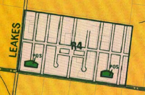
The issue was finally resolved in 1992, following the implementation of the Chartwell Restructure Allotment Plan. The 491 lots were reduced to 62, the bulk being around 0.6 hectares in size, the exception being 14 already occupied by dwellings.
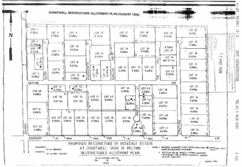
Chartwell Restructure Allotment Plan
In the years since, the number of houses on the estate has risen to 16.
And the future
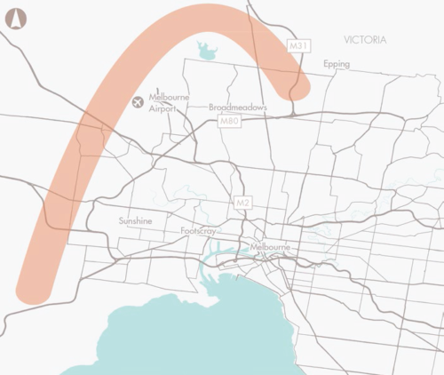
In 2008 plans for the Outer Metropolitan Ring Road were made public, to connect the Hume Freeway at Kalkallo in the north, to the Princes Freeway south-west of Werribee.
But one problem for the residents of Chartwell – the freeway alignment went straight through the middle of the estate.
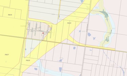
VicRoads Public Acquisition Overlay, via Land Victoria
The City of Melton made a submission to the ‘Delivering Melbourne’s Newest Sustainable Communities’ study.
The Chartwell Estate on Boundary Road is a small closer settlement of around 15-20 houses. The proposed alignment has a major impact upon this settlement, and would effectively see its complete destruction. This is likely to have significant social implications. Whilst Council appreciates that there are significant engineering constraints associated with the alignment of the OMR, the impact of this outcome should not be underestimated, and Council would urge VicRoads to explore whether there are alignment options which might see the OMR avoid Chartwell.
But the final route of the freeway was still pushed through the estate.
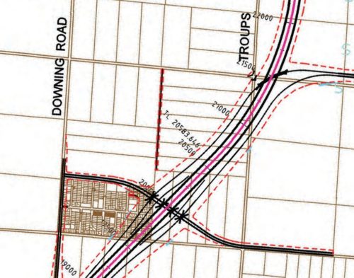
OMR Transport Corridor Design Sheet 4
A note on Public Acquisition Overlays
You might have noticed something a little odd about the Public Acquisition Overlays marked in yellow on this map – PAO3, PAO5 and PAO7.

VicRoads Public Acquisition Overlay, via Land Victoria
Turns out Public Acquisition Overlay numbers are only unique to the planning scheme that they belong to, and not unique across the state. In the case of Chartwell, the estate sits on the border of two:
The top half is the Melton Planning Scheme:
- PAO3: Outer Metropolitan Ring / E6 Transport Corridor
- PAO5: Western Grassland Reserves
While the bottom half the Wyndham Planning Scheme:
- PAO5: Outer Metropolitan Ring / E6 Transport Corridor
- PAO7: Western Grassland Reserves
Clear as mud?
And a note on the Western Grassland Reserve
The Western Grassland Reserve was established in 2009 to protect remnant grasslands, and offset urban sprawl, but only 9% of land has been acquired so far. So what’ll be finished first – freeway or grassland?
Sources
- Volume 2 – The Environmental Thematic History, the Shire of Melton Heritage Study, David Moloney
- Victorian Ombudsman, Quarterly Report, 30 September 1981

Fascinating and well researched article – many thanks!
Cheers!
Marcus,
this sounds very similar to Solomon Heights in Sunshine. The street names there are:
Baldwin Ave
Balfour Ave
Whitehill Ave
Munro Ave
Vermont Ave
Rankin Ave
Penna Ave
Elwood Ave
Auburn Ave
Burwood Ave
West Ave
Solomon Heights triggered this post – I wrote about it back in 2016:
https://wongm.com/2016/06/sunshine-north-abandoned-subdivision/
I wonder how the “estate” at Merton St & Harcourt Rd, Altona compares to this.
That’d be the ‘Burns Road Industrial Estate’
https://www.hobsonsbay.vic.gov.au/Services/Planning-Building/Planning-Scheme-Amendments-and-Strategic-Planning-Current-Projects/Current-Projects/Burns-Road-Industrial-Estate
[…] between Werribee and Rockbank is Chartwell Estate – a subdivision created in the 1950s and marketed to new English migrants, and since […]
[…] Rosedale Estate at Chartwell […]
Thanks for this Marcus, really interesting read. I have been interested in this estate since noticing it sticking out in the Melway many years ago, and was able to find a bit of what you found. Good to find some extra details.
Glad you enjoyed the post!