Photos from ten years ago: November 2014

Another instalment in my photos from ten years ago series – this time it is November 2014.

A trip to Sydney

I decided to make the trip up to Sydney this month, catching the XPT north from Melbourne.

XPT led by XP2010 on arrival at Sydney Terminal

And being greeted by a light rail vehicle tram as soon as I arrived at Central Station.

Urbos 3 LRV 2115 awaiting departure time from Central Station

I saw a double decker train the next day.

Millennium set M22 arrives into Marrickville

And presumably took some other photos up there, but they weren’t of trains – as I still haven’t uploaded them to my Flickr account.

Then then flew back home to Melbourne – to be greeted by a Myki visitors pack advertisement inside the Qantas terminal.

Myki visitors pack advertisement inside Qantas Terminal 1 at Melbourne Airport

Along with a SkyBus one.

SkyBus advertisement inside Qantas Terminal 1 at Melbourne Airport

A decade on and the Myki machines at Melbourne Airport are just as hard to find, and SkyBus is still the only public transport route that runs from the airport to the CBD.

Melbourne Central

I also went on a tour of the Melbourne Central Tower this month, where we got to look out over the roof of Melbourne Central Shopping Centre, towards Myer House and Emporium.

Looking over to Myer House and Emporium from Melbourne Central

But unfortunately we only got to look down on the glass cone, not look inside like some previous tours did.

Looking over to the Melbourne Central Shopping Centre from inside Melbourne Central Tower

Technology

It seems like an everyday scene now, but a decade ago seeing an entire tram full of passengers absorbed in their smartphones was still novel.

Tram full of passengers absorbed in their smartphones

But Telstra was still behind the times – rollout out their ‘Telstra Air’ wifi hotspots to payphones, despite almost everyone having stacks of mobile data to use on their phone.

Installing a Telstra Air wifi hotspot at an existing payphone

The Wi-Fi network is still in place today, but free since 2023.

Trams

‘Safety’ zone trams stops were still common place in the Melbourne CBD a decade ago – this one was on Collins Street at William Street.

Passengers spill out of a 'safety' zone on Collins Street at William Street

This particular tram stop was replaced by a platform stop in June 2015, with the last safety zones in the CBD upgraded in July 2024. As for the rest of the tram network – the December 2022 deadline to make all tram stops accessible has been and gone, with hundreds still non compliant.

Meanwhile Yarra Trams was coming up with crackpot schemes like a coffee stall taking up precious space for passengers at the Flinders and Swanston Street stop.

Coffee stall taking up precious platform stop space at Flinders and Swanston Street

Luckily that idea got kicked out very quickly.

A handful of 1970s-era Z1 class trams were also still kicking around the network, with their crappy little sliding windows and only two doors per side – despite having supposed to have been retired a decade earlier in favour of the incoming low floor C and D class trams, but kept on due to increasing patronage.

Z1.86 northbound on route 5 at Swanston and Flinders Street

This particular tram – Z3.86 – was eventually retired in August 2015, following the delivery of the new E class trams.

A different flavour of stupidity are people who drive down Swanston Street – this driver managed to break down in the middle of the tram stop, and drum up help from passersby to get clear of the tracks.

Passersby push a broken down car out of the tram stop on Swanston Street

While this confused country bumpkin headed up Swanston Street in their LandCruiser got pulled up by an unmarked police car, and got sent on their way.

A confused motorist at the corner of Swanston and Bourke Street gets pulled up by an unmarked police car

And a decade on – nothing much has really changed.

V/Line trains

Here we see an original liveried VLocity train departing Richmond station for the city.

Tail end of VLocity VL11 and classmate at Richmond Junction, waiting for a signal towards Southern Cross

These days the entire VLocity fleet is in the PTV purple livery, the open air ramps at Richmond station are now roofed over, and Eureka Tower has been usurped by Australia 108 as the tallest building in Australia.

Down in Geelong I photographed a 6-car V/Line train approaching the brand new terminus station of Waurn Ponds.

VLocity 3VL51 and classmate arrive into Waurn Ponds station on the down

Opened in October 2014, Waurn Ponds gained a second platform in 2022, and the 8 kilometers of track between South Geelong and Waurn Ponds has just been duplicated.

And a V/Line train in are more shocking condition was VLocity set VL12.

VLocity carriage 1112 has much more damage to the cab, with the pilot having been cut off

Involved in a collision on the Werribee line in August 2014 where a V/Line train passed a signal at stop and crashed into the rear of a Metro train, it had to be dragged to the workshops at Bendigo to be repaired.

B75 and T386 transfer damaged VLocity set VL12 to Bendigo at Sunshine

The collision resulted in Metro trains rewriting the rules around passing a signal at stop, while VLocity VL12 reentered service in March 2015 as the only 2-car VLocity set to ever wear the PTV livery.

A load of rubbish

After the removal of rubbish bins from Melbourne stations due to the “increased terror alert level”, they all got dumped in a pile at Flinders Street Station.

Now redundant rubbish bins stored in the 'Milk Dock' at Flinders Street

And the average passenger responded as you might expect – like a filthy pig just leaving their rubbish on the ground.

Rubbish litters the platforms now that the bins have been taken away

The bins were eventually returned in March 2015, with the exception of the private management at Southern Cross Station, who still refuse to place any rubbish bins on their platforms.

A different kind of rubbish

It was the leadup to the 2014 State Election, and the Napthine Government was ramped up their ‘Moving Victoria’ campaign, promoting their unfundedthe Melbourne Rail Link project.

'Moving Victoria' propaganda stickers on the back of train seats, spruiking the Melbourne Rail Link project

Conceived as an alternative to the Metro Tunnel, the Melbourne Rail Link tunnel would have run between South Yarra and Southern Cross, serving new stations at Domain and Fishermans Bend – instead of Arden and Parkville, who would be stuck using buses and trams.

But as you might have guessed, the Melbourne Rail Link project went nowhere, construction of the Metro Tunnel started a few years later and is almost finished, work on the Melbourne Airport Rail project has been stop-start, and a rail link to Fishermans Bend is as far away as ever.

And another piece of pork barrelling I photographed was this Denis Napthine’s $115 million dollar train on the Frankston line – or what the government called the ‘Bayside Rail Project’.

X'Trapolis 176M heads to Frankston on the day before the 2014 State Election

Announced in May 2013, the Bayside Rail Project was promoted as bringing the newest trains in Melbourne – the X’Trapolis – to the Frankston line.

However these trains accelerate faster than anything else in the Melbourne fleet, putting them at risk of beating the boom barriers at level crossings, but because of the upcoming election, it was decided in October 2014, to just run a single X’Trapolis train on the line each morning, but with a speed restrictor on the throttle and two drivers in the cab.

Following changes to level crossing timings on the line in August 2016, the restriction on X’Trapolis trains was removed, allowing any X’Trapolis set to run revenue services to Frankston, and more amazingly a decade later, the bulk of the level crossings on the Frankston line don’t even exist anymore.

And a third kind of rubbish

For decades this ancient advertisement for Medibank Private faced passengers at Melbourne Central platform 1.

Ancient advertisement for 'Medibank Private' still in place at Melbourne Central platform 1

But 2014 saw this billboard finally removed from the platform wall, replaced by the ‘Xtrack TV’ digital screens with their insipid loop of advertisements – with audio soundtrack.

And Medibank Private – it’s still just as useless as the rest of the Australian private health insurance system.

Footnote

Here you can find the rest of my ‘photos from ten years ago‘ series.

Freeway spaghetti bowl at Keilor Park

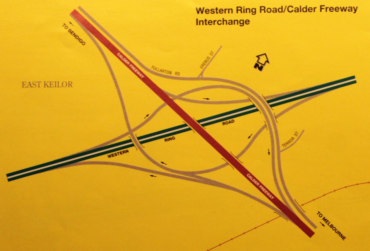
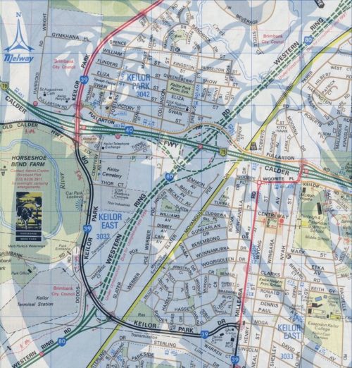
If there is a most underrated freeway interchange in Melbourne, it would have to be that between the M80 Western Ring Road and the Calder Freeway at Keilor Park.
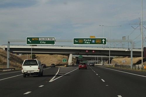
Northbound on the Western Ring Road at the Calder Freeway

Taking a tour

From the air there is a tangle of freeway lanes, ramps and frontage roads.

Freeway interchange between the Western Ring Road and the Calder Freeway

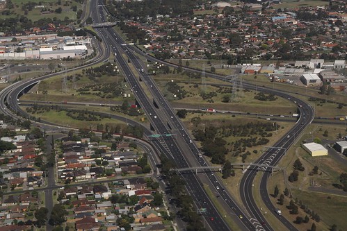
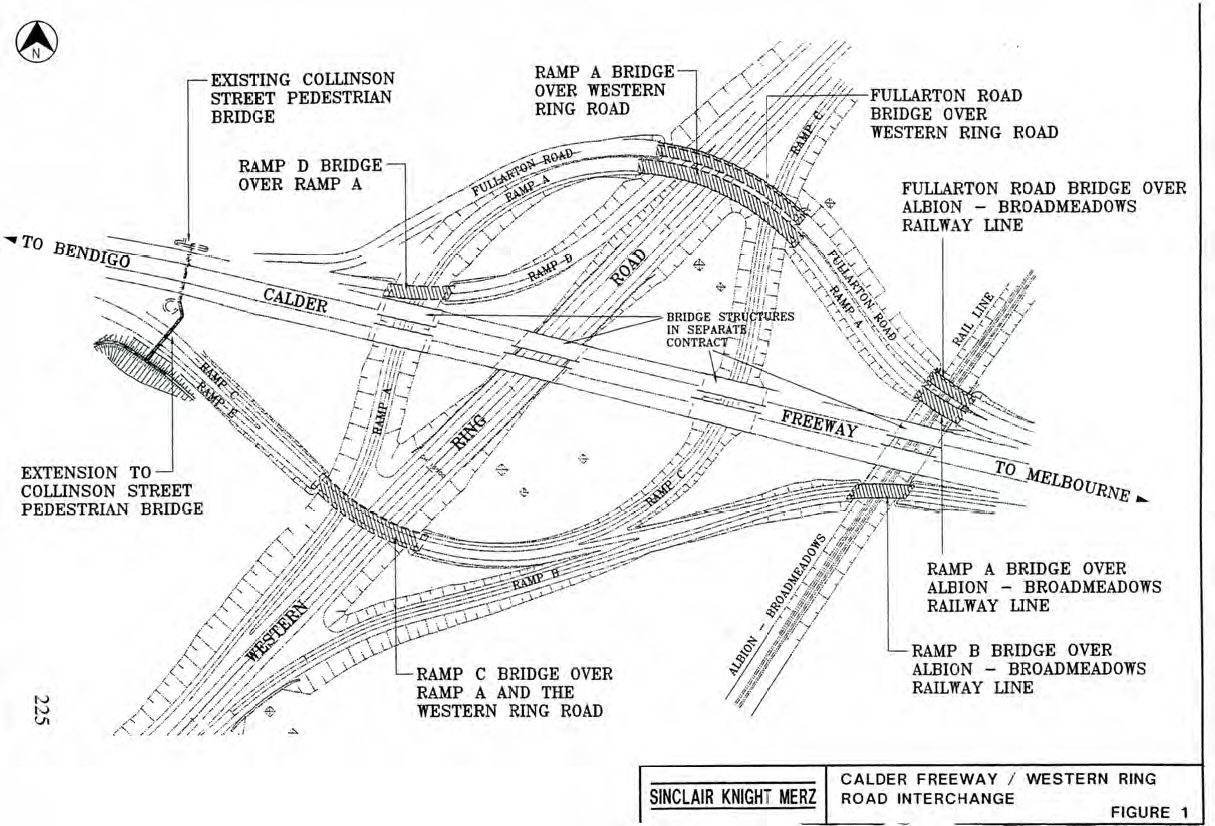
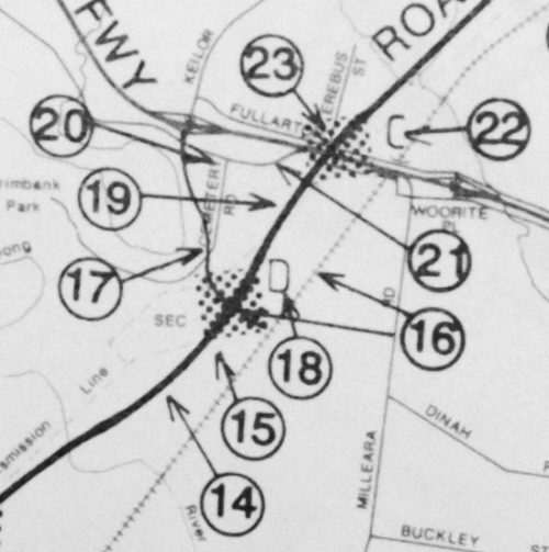
The interchange having a total of sixteen bridges.

Including:

  • two taking the Calder Freeway over the M80 Ring Road,
  • five taking the Calder Freeway over freeway ramps,
  • two taking freeway ramps over the M80 Ring Road,
  • five bridges over railway tracks,
  • one taking Fullarton Road over the interchange,
  • and finally, a pedestrian footbridge at Collinson Street.

And increasing the complexity of the interchange are two other features – the Fullarton Road ‘frontage road’ skirts the northern edge, and Calder Freeway westbound exit for Keilor Park Drive is via a collector/distributor lane arrangement with the M80 Ring Road ramps.

But the despite the number of bridges, only four out of the possible eight freeway-to-freeway movements are possible:

  • M80 Ring Road southbound > Calder Freeway westbound,
  • Calder Freeway westbound > M80 Ring Road southbound,
  • M80 Ring Road northbound > Calder Freeway eastbound, and
  • Calder Freeway eastbound > M80 Ring Road northbound.

The other four movements being catered for by other routes:

  • M80 Ring Road southbound > Calder Freeway eastbound via Tullamarine Freeway from the M80 Ring Road interchange,
  • Calder Freeway westbound > M80 Ring Road northbound via Tullamarine Freeway from the Calder Freeway interchange,
  • M80 Ring Road northbound > Calder Freeway westbound via Keilor Park Drive, and
  • Calder Freeway eastbound > M80 Ring Road southbound via Keilor Park Drive.

And local traffic – for the Calder Freeway they have to use the Woorite Place, Fullarton Road or McNamara Avenue exits; for the M80 Ring Road they need to use Keilor Park Drive or Airport Drive.

So how did this mess of roads come to be?

A history of the Calder Freeway, Keilor Park Drive, and the M80 Western Ring Road

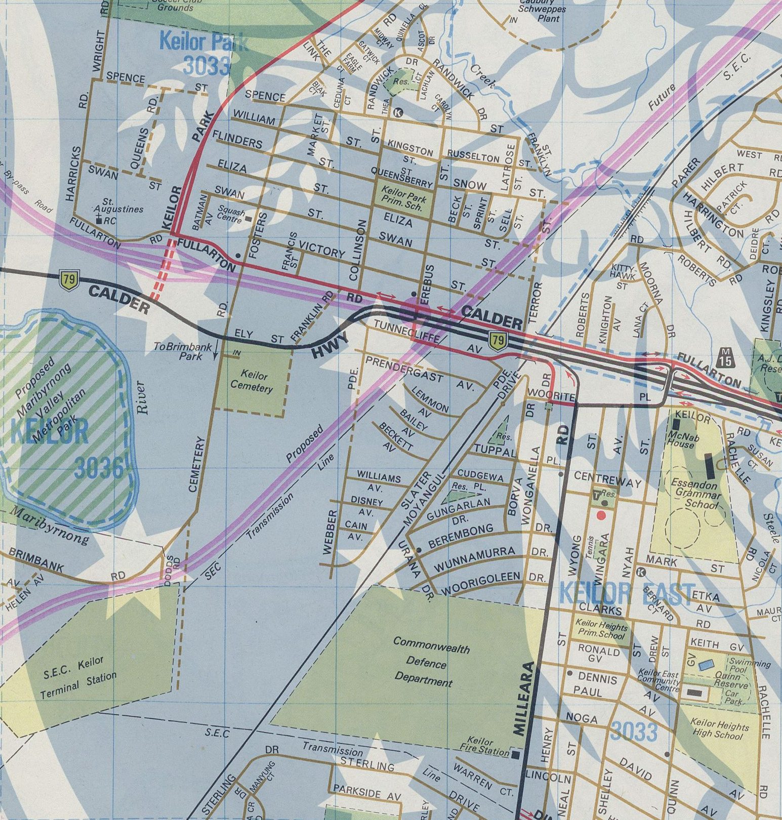
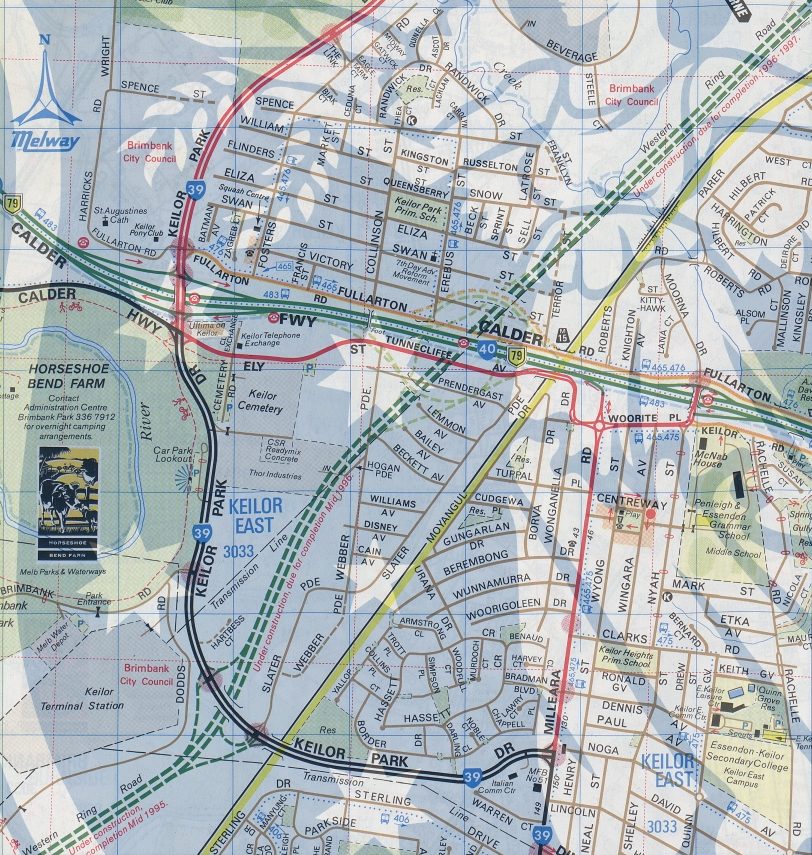
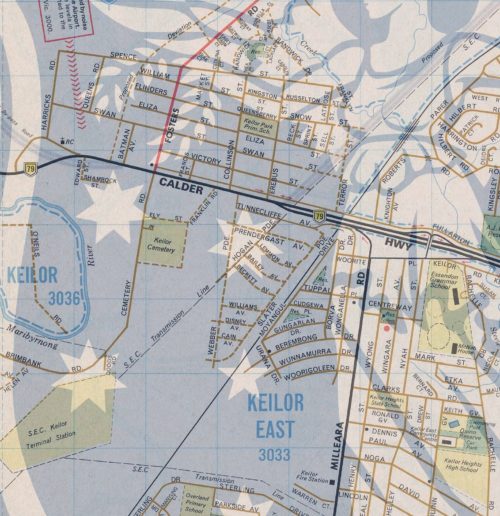
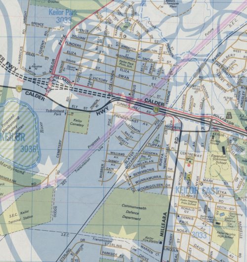
We start back in 1971, when Keilor Park was a recently developed suburb, there was no such thing as Keilor Park Drive, and the Calder Highway was just a normal road. The only sign of what was to come – two faint purple lines marking future freeways.


Melway edition 5, 1971

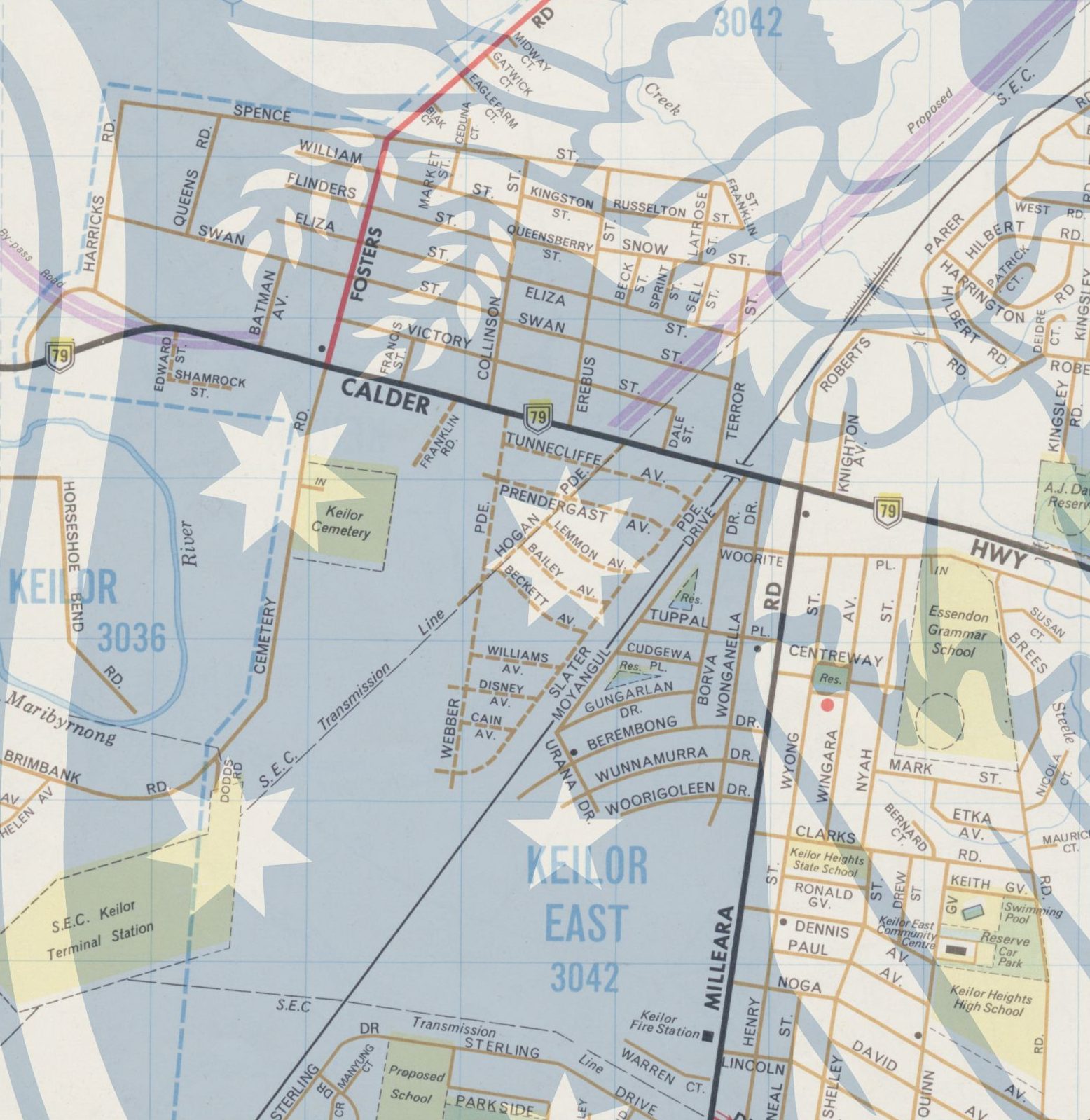
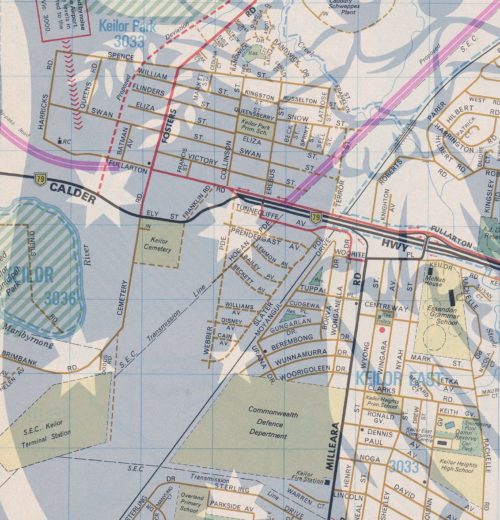
By 1975 the first stage of the Calder Freeway had been completed from Niddrie, terminating at Keilor East – and the first sign of Keilor Park Drive.


Melway edition 8, 1975

By 1976 the Calder Highway had been deviated towards the Keilor Cemetery, ready for a freeway extension.


Melway edition 9, 1976

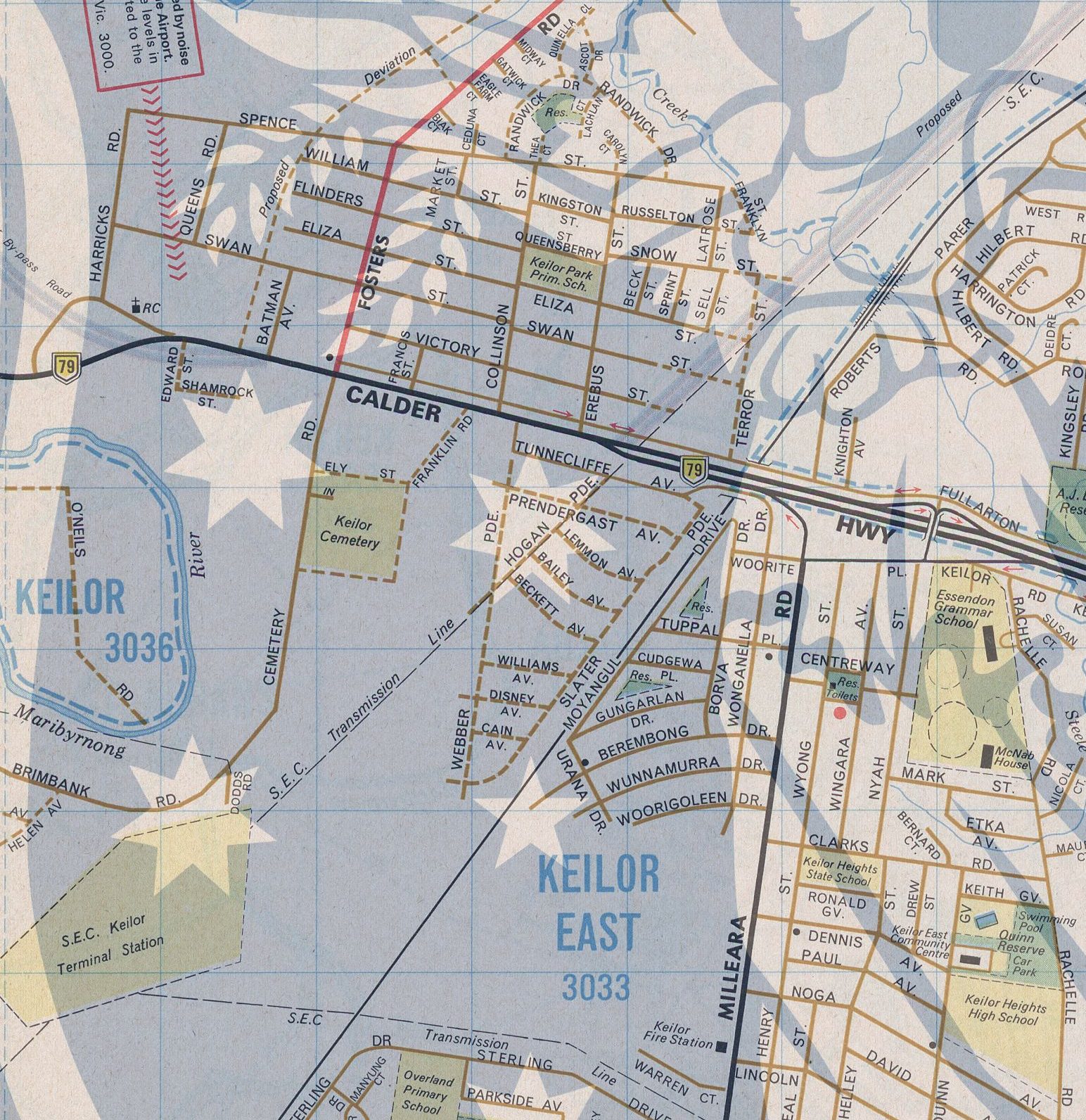
Keilor Park Drive was completed by 1978, and the planned ring road alignment had been extended south of the Calder Freeway.


Melway edition 11, 1978

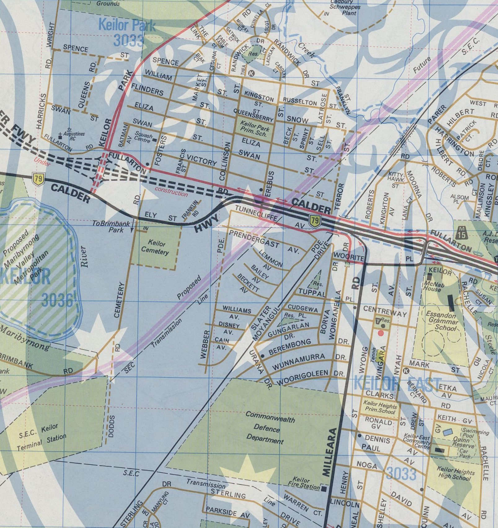
By 1979 work on the Calder Freeway extension west to Keilor was underway.


Melway edition 12, 1979

Completed by 1982.


Melway edition 14, 1982

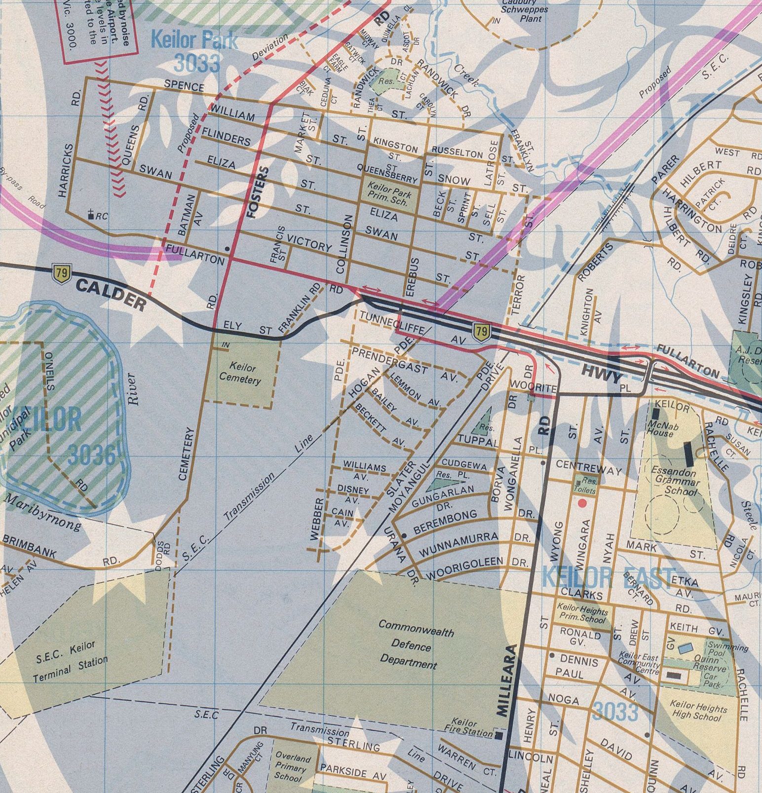
There things stayed still, until 1989 saw the planned alignment for the Western Ring Road tweaked.


Melway edition 19, 1989

The debate over the interchange

Early planning for the Western Ring Road was undecided about the provision of an interchange with the Calder Freeway, due to the impacts on the surrounding area.

The planning scheme reservation across the Calder Freeway is about 30 metres wide and is inadequate to accommodate the WRR. No allowance was made in previous planning for the additional land that would be required for an interchange between the WRR and the Calder Freeway . As a result, development has been allowed to proceed right up to the reservation boundary. South of the Calder Freeway is the East Keilor industrial area, consisting of small industrial premises, while to the north is the residential area of Keilor Park.

Four interchange options were subject to detailed investigation.

  • a ‘no-interchange’ option requlrlng turning traffic between the Calder and the WRR to use nearby local access interchanges and local roads . This would include grade separation of the two routes and acquisition of 15 business premises at a cost of $14m. It would cause significant increases in through traffic on local roads;
  • build an interchange, with a range of alternatives examined including a diamond interchange (with signals on the WRR), a bridged rotary and a number of freeway to freeway variations. The cost would range from $27m for a diamond to $52 for freeway to freeway. Up to 75 business premises and 30 houses would be required.

The recommended solution was a two-level interchange with turning roadways in two quadrants, with a September 1989 information bulletin stating.

There has been a lot of community discussion about whether or not an interchange should be built to connect the WRR with the Calder Freeway.

If an interchange were not built, there would be big increases in traffic on local arterial roads, such as Milleara Road and Keilor Park Drive. An interchange is therefore favoured despite its estimated cost of up to $50m and the effect on a number of houses and businesses.

Following recent discussions with local residents, further ideas have been examined. These would not separate through traffic from local traffic, and would still impact on a similar number of properties.

It is therefore proposed to reserve enough land for an interchange at the location originally shown (immediately west of the SEC power lines).

This would require a section of Fullarton Road to be moved. Space would be provided for landscaping and noise barriers to protect houses in Keilor Park.

These changes being included in the Western Road Road Environmental Effects Statement advertised in December 1989.

Featuring a long list of land use changes in Keilor Park and East Keilor.

Including:

14)

The Proposed Secondary Road link to Cecelia Drive is to be deleted. It previously provided a local connection between Buckley Street and the Calder Freeway which is now to be via the Dodds Road interchange and the new connection through former Commonwealth land to Milleara Road (see item 16 below). The reservation is to be rezoned to appropriate abutting zoning (Residential C and Proposed Public Open Space reservation).

15)

An area of land to the north of the previous Cecelia Drive route, which is zoned for Reserved Light Industrial, will be impossible to develop for industrial purposes because of access difficulties. It is proposed to be rezoned to Proposed Public Open Space as an extension of the Maribymong Valley Park. The area will be capable of providing for pedestrian/cycle access into the park from the new Dodds Road connection. It is owned by the MMBW.

16)

A large area of land reserved for Commonwealth purposes in Milleara Road has been sold and is being subdivided for housing. The site is to be rezoned to Reserved Living, in accordance with the proposed use. Incorporated within the zone will be a Secondary Road reservation which provides for the connection between Dodds Road interchange and Milleara Road, on the alignment included within the approved plan of subdivision.

17)

As part of the necessary connections between the existing road network and the Ring Road, the Roads Corporation are intending to construct a connection between the Dodds Road interchange and Keilor Park Drive. This route will utilise the existing reservation and Cemetery road to the southern boundary of the cemetery, then deviate westwards to join Keilor Park Drive. A portion of Brimbank Park, reserved for Proposed Public Open Space, is to be amended to Proposed Secondary Road and an excised remnant amended to Proposed Cemetery to allow for future expansion of the adjoining Keilor Cemetery. The deviation shall involve the least acquisition necessary to achieve a satisfactory road alignment.

18)

Land north-east of the proposed Dodds road interchange has recently been subdivided for industrial purposes. The zoning is to be rationalised to provide a Reserved Light Industrial Zone along the railway opposite future housing (Item 16). A proposed reservation for re-instating access to the Slater Parade Industrial Area is also provided (Proposed Public Purposes 20).

19)

The area between the new Dodds Road/Keilor Park Drive link and the Ring Road is currently zoned for a variety of industrial and other uses. It is intended to rationalise the zoning for this area.
The existing Reserved Light Industrial and Reserved General Industrial Zones will be amended to a Restricted Light Industrial zone which will allow greater control over buildings and works.

20)

Land severed from Brimbank Park by Cemetery Road deviation and public open space reservation due east of the Keilor Cemetery is proposed to be included in a Proposed Cemetery Reservation. This will provide for a much needed extension of the cemetery. Open space lost in the extension will be replaced in the area south of Dodds Road interchange (see Item 15).

21)

Access is to be restored to the properties west of the Ring Road in the Prendergast Avenue area. The new road (shown as Proposed Public Purposes 20) will provide subdivisional opportunities which can be taken up by the owner by agreement with the Council and the Roads Corporation.

22)

The Roads Corporation proposes to construct a freeway-to-freeway interchange between the Ring Road and the Calder Freeway. The construction may take place in stages, to match traffic growth and may initially include some at grade intersections with traffic signals. These would later be replaced by free flow ramps. The Proposed Main Road reservation included in this amendment provides for the total land requirements for the final interchange. This also provides for a deviation of Fullarton Road around the interchange to maintain access between Keilor Park and Airport West.

23)

The present planning scheme shows the Calder Freeway between Woorite Place and the Maribyrnong River as a mixture of Main Road, Proposed Main Road and Road Widening reservations. The boundaries of these reservations have been changed to match the layout of the freeway.

Time to build

Plans for the Western Ring Road had been made real by 1991, when a whole slew of new proposed roads added to the Melway – including the Western Ring Road, an interchange with the Calder Freeway, and a southward extension of Keilor Park Drive to Milleara Road.


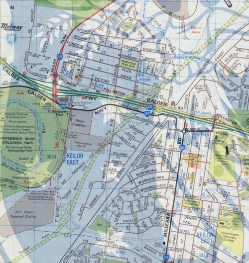
Melway edition 21, 1991

Work started on the 2.6 km long extension of Keilor Park Drive to Milleara Road in 1993, opening to traffic on 11 April 1994 at a cost of $20 million. A further $5 million was spent on the duplication of Keilor Park Drive and Sharps Road, in preparation for the traffic that the next stage of the Western Ring Road would bring – but the Calder Freeway interchange was still ‘proposed’.


Melway edition 23, 1995

But the interchange was approved soon after – detailed design work commenced in 1992 with construction planned to start in 1996, with completed by 1998. However additional funding from the Federal Government saw the project sped up – construction commenced in May 1994 under two contracts, with a 90 week deadline:

  • Stage 1: $30 million contract with Fletcher Construction Australia and Sinclair Knight Merz for the construction of four road bridges, three bridges over rail lines and the extension the existing pedestrian footbridge.
  • Stage 2: $14.6 million contract with Transfield Constructions and Roche Bros to widen the Calder Freeway from Keilor Park Drive to McNamara Avenue, build six road bridges, and widen two bridges over the railway.

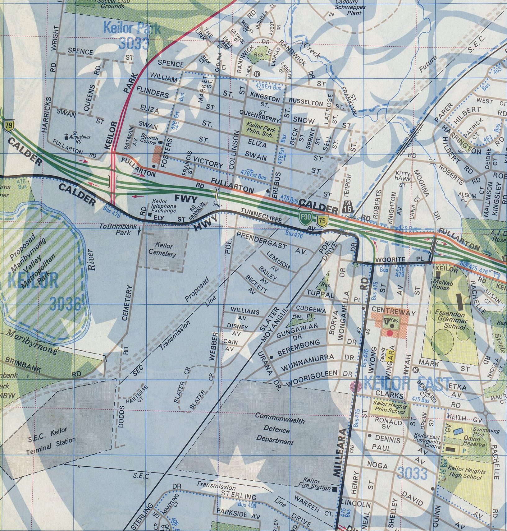
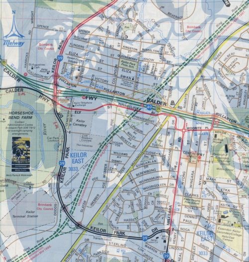
1996 saw the interchange marked as ‘under construction’ in the Melway, and the western ramps at the Calder Freeway / Woorite Place interchange had been closed.


Melway edition 24, 1996

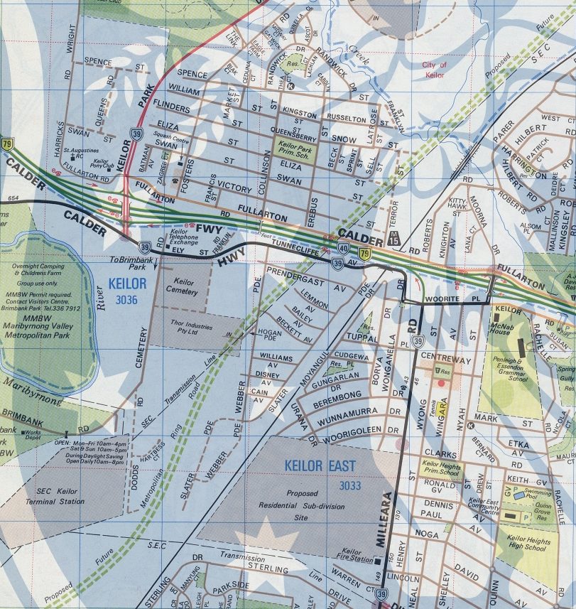
With the freeway network reaching the current state in 1998.


Melway edition 25, 1998

Today the only different is the number of lanes: the Western Ring Road north of the Calder Freeway interchange was widened to four lanes in 2013, the section to the south following in 2018.

And the streets wiped off the map

To make room for the freeway interchange a compulsory acquisition process was started in 1993, and by February 1995 twenty out of 30 houses in Keilor Park had been demolished, with 75 commercial and industrial properties due to follow.

By the time the area was cleared, Prendergast Avenue, Webber Parade, Tunnecliffe Avenue, Hogan Parade had all been wiped off the map, along with a portion of the ‘Milleara Estate’ by landscape architect Walter Burley Griffin, designer of Canberra.

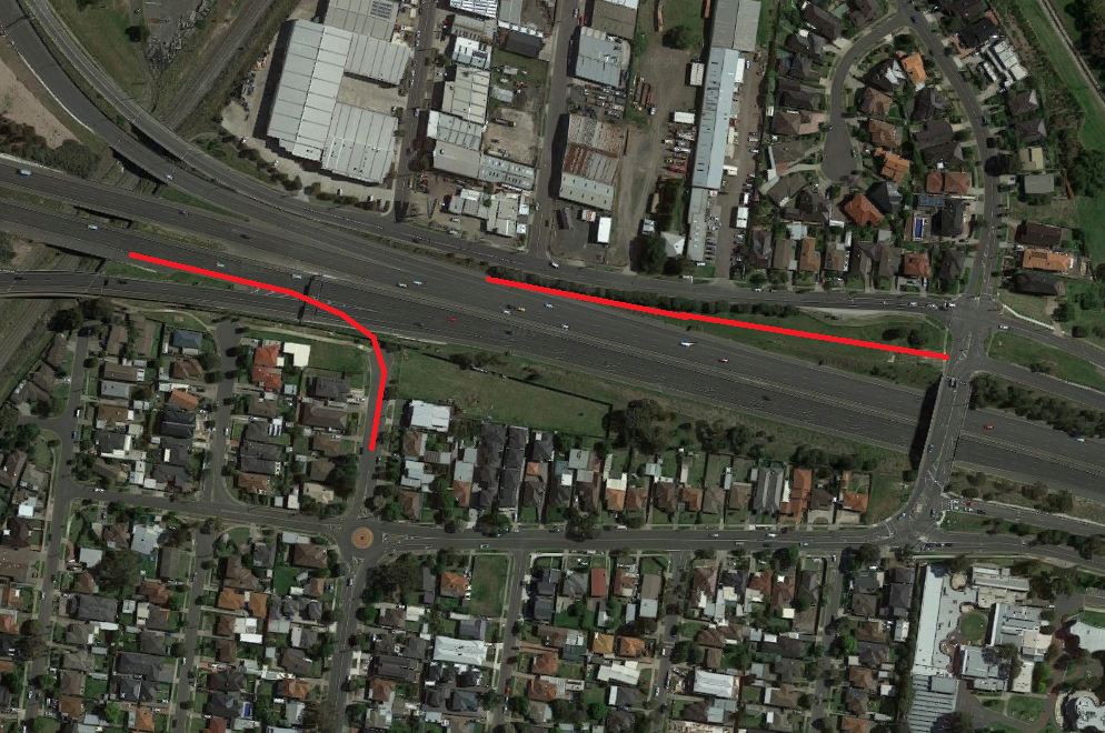
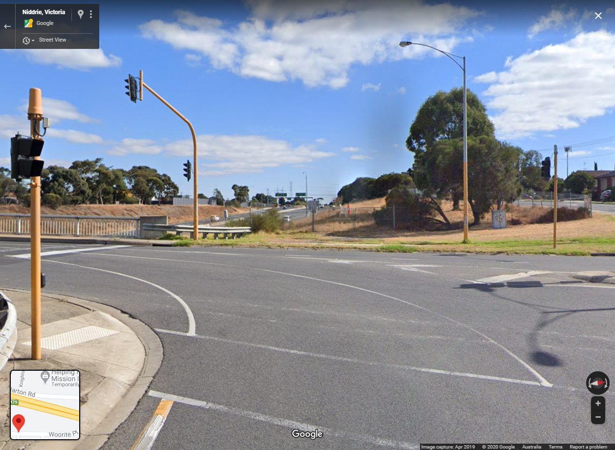
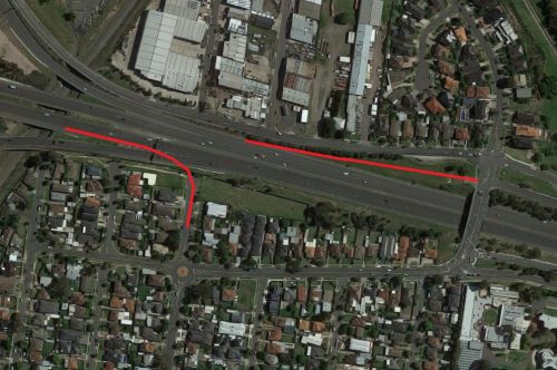
Footnote: ghost ramp on the Calder Freeway

The interchange of the Calder Freeway and Woorite Place was once a full diamond, but the ramps to the west were removed to eliminate weaving movements with traffic from the Western Ring Road.


Google Maps

The remains on the eastbound off ramp are still visible today as a ‘ghost ramp‘.


Google Street View

Footnote: building bridges

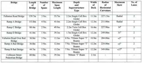
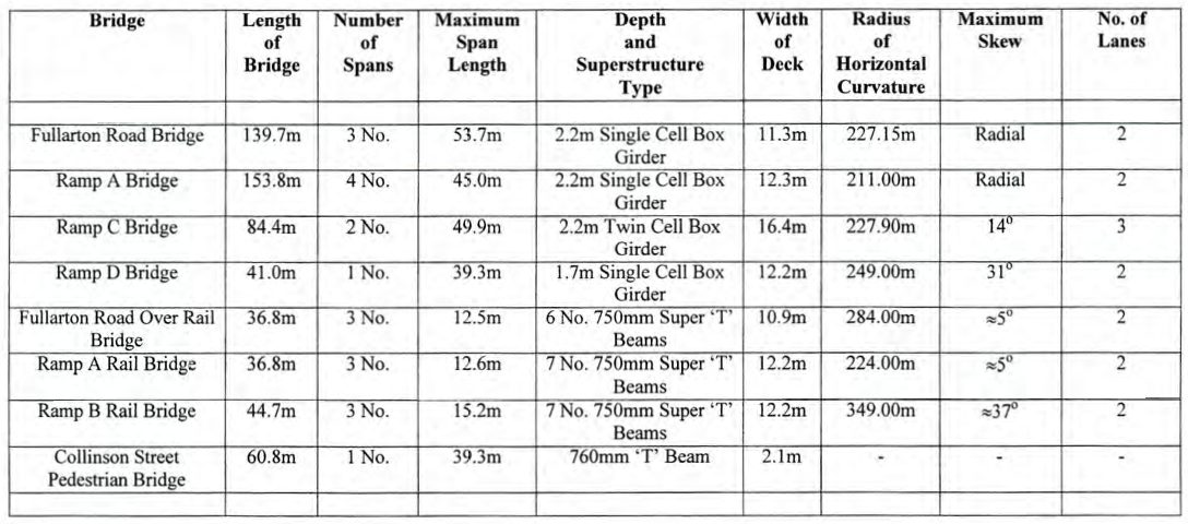
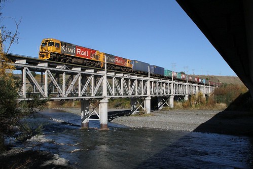
The paper Design and Construct Bridge Structures on the Western Ring Road — Calder Freeway Interchange by Mark Percival and Duncan Kinder details the construction of the bridges at the interchange.

Each of a unique design.

Fullarton Road Bridge
Fullarton Road formerly ran parallel to the Calder Freeway between Matthews Avenue to the east and Keilor Park Drive to the west, providing vehicular access to private housing on the northern side of the freeway. Construction of a grade separation structure over the proposed Western Ring Road was required to maintain this access. The bridge carries two lanes of traffic (one in each direction) and has a 2m wide footpath located along the northern side of the bridge.

Ramp A Bridge
This bridge was provided to allow vehicles travelling north along the Western Ring Road to exit off the Ring Road and join the Calder Freeway, leading back into Melbourne. The bridge is constructed parallel to the Fullarton Road Bridge and spans over the Western Ring Road, Ramp C and Ramp D.

Ramp C Bridge
Ramp C provides access for traffic heading south along the Western Ring Road to exit north towards Bendigo along the Calder Freeway.

Ramp D Bridge
This bridge provides access for southbound traffic from the Calder Freeway to enter the westbound carriageway of the Western Ring Road. As well as being curved in plan, it has a high skew. (21° at the west abutment, 30° at the east abutment)

Fullarton Road over Rail Bridge, Ramp A Rail Bridge and Ramp B Rail Bridge
Ramp A and Ramp B Rail Bridges were provided to allow access on or off the Western Ring Road, and Fullarton Road over Rail Bridge was required to maintain access to the existing access road. All three bridges over the Albion to Broadmeadows Rail Line provide for two lanes of traffic. The Fullarton Road over Rail Bridge also included a pedestrian footpath. Each bridge comprises three simply supported spans varying in length from 11.4m to 15.2m.

Collinson Street Footbridge
The existing Collinson Street Footbridge over the Calder Freeway required extension to provide access over both Ramp C and E. The existing circular ramp at the southern end of the bridge was demolished and the bridge extended at the south end with 4 additional spans.

The curved road bridges were concrete box girders cast in place, with the roadway beneath excavated following completion of the bridge; while the bridges over the railway were conventional super ‘T’ beams lowered into place by cranes.

Putting the computer system before the train

Over the years there have been many examples were real world processes being squeezed to fit in with what a computer system can support. Well the railways are no stranger to this, as these examples show.

N455, N452, N470, N472, VLocity VL22 and VL80 stabled at Dudley Street

Some background

Locomotives all look the same, so it’s not like you can tell a train driver “you’re driving the red one today” – you need a way to tell them apart. Enter a favourite topic of trainspotters – numbering systems.

T320 at the Seymour Railway Heritage Centre

Each locomotive gets a number – and most of the time locomotives of the same type get numbered in the same series of numbers, and either the first few digits or some letters in front indicate the ‘class’ of locomotives.

And from there the numbers get to track maintenance for a given unit, and allocations of locomotives to a given service. Initially these processes were were all paper based, and undertaken by an army of clerks back at head office.


PROV image VPRS 12903/P0001, 287/09

But in the 1970s there was something new sweeping the world of business – computers.

And over time, railways around the world also decided to adapt their existing processes to the new world – but not without trouble.

Number shuffling at Australian National

In 1980s the Australian National Railways Commission – operator of freight and passenger trains from Adelaide towards Western Australia, Alice Springs, Broken Hill and Victoria – introduced the ‘Traffic Information Management System’ (TIMS) to make their railway more efficient.

Their 1984/1985 annual report stating

Implementation of AN’s computerised wagon monitoring system will dramatically increase utilisation of wagons and locomotives. A sub-system to maintain a comprehensive on-line rollingstock inventory was implemented in October 1984. Partial implementation of the remainder of the system occurred in July 1985, with full implementation due in December 1985.

As part of this, ‘check digits‘ were added to the existing fleet number of each locomotive, wagon and carriage, so that if a number was accidentally mistyped into the new system, the computer would know it was wrong, and prompt the user to correct it.


Australian National annual report 1985/1986

But there was also a problem – locomotives inherited from the South Australia Railways had been numbered as numeric ‘classes’ – where the class leader had the same number as the class name, for example ‘830’ class locomotive ‘830’ and ‘930’ class locomotive ‘930’ – and the new computer system was not able to handle the duplication.

So the solution for Australian National – renumber the class leaders! The next spare numbers were at the end of the existing number groups, so locomotive ‘830’ was renumbered to ‘875’, locomotive ‘930’ became ‘967’, and so on..

And a real doozy in New Zealand

The New Zealand Railways were a relatively early adopter of computers, with their ‘Traffic Monitoring System’ introduced in the 1970s.

Wikipedia has this to say about it.

On 12 February 1979, NZR introduced a computerised “Traffic Monitoring System” (TMS) nationwide. Implementation was completed in December 1980.

A pilot scheme of TMS began in 1973 on the Palmerston North – Gisborne Line between Woodville and Gisborne. TMS resulted in an 8 per cent improvement in wagon utilisation. In 1977, NZR decided to implement the system out across the entire network. Using dual IBM System/370 systems, one in active standby mode, the TMS system became a centralised system for tracking all wagon and locomotive movements.

As a result of the introduction of TMS, NZR identified that it could reduce its total wagon requirements by 10 per cent of its 1980 fleet, resulting in the withdrawal of many older wagon types. NZR later sold its expertise and some of the TMS software to Victorian Railways in Victoria, Australia and the State Rail Authority (SRA) in New South Wales, Australia.

But the historical New Zealand Railways locomotives classification scheme that relied on superscript characters (eg: DA and EW) didn’t work on the new computer system, so the classes were changed to machine readable uppercase characters (eg: DA and EW).

NZR locomotive DI 1102 runs around the train on the Weka Pass Railway at Waikari station

But that wasn’t the only change – the decision was also made the renumber the entire locomotive fleet, across new number groups, with new numbers, in a system completely unintelligible at first glance – four digit non-sequential numbers. An example is the DC class locomotives of 1979 – 85 were built as DC 1551 through 1599, but now operate as DC 4006 – 4951. So what gives?

The first secret behind the system is the meaning of each digit – the final one is a check number, giving DC class locomotives 400 through 495 – which sounds somewhat sensible, other than the fact only 85 DC class locomotives were ever built, so there’s 10 extra numbers in the series.

The answer to that mystery – I found it on a British railway forum, of all places.

The New Zealand check-digit system doesn’t work like the UIC/EVN system – it’s more complex, not least because it has to cope with vehicle classes which are letters, and variable-length numbers. The way it was explained to me (nearly 20 years ago, so it’s a bit hazy now) is that the check digit calculation can come up with a number between 0 and 10 – not 0 and 9 like the EVN. When it’s a 10, there’s no way to handle it in the computer system, so that number is just rejected and they skip to the next one. So, yes, there are gaps in the fleet number sequence, and that’s just how the system works. The New Zealanders are used to it, and don’t expect to have a continuous list of numbers.

So that’s two layers on indirection in the New Zealand rolling stock numbering system – my brain hurts.

KiwiRail DXR 8007 leads DXB 5120 on 736 northbound freight from Christchurch to Picton over the Awatere River bridge at Seddon on the South Island

Further tools

A history of smoking on Victorian trains

Fortunately I’m young enough to have never suffered through the days of when people were allowed to smoke onboard trains in Victoria, but can remember when people were allowed to smoke at railway stations. So here is a quick history of when smoking bans were introduced.

Pile of dumped cigarette butts in the Sunshine Marketplace car park

Back in the bad old days

Going back the very start of trains in Victoria, entire carriages were designated as ‘smoking’ and ‘non-smoking’.


VPRS 12800/P1, item H 4165

But with the introduction of electric suburban trains from 1919, carriages were divided up instead – three smoking and six non-smoking compartments, with a full length partition dividing the two.


Weston Langford photo

This layout was retained in Harris trains of the 1950s.

SLV image H31188 - Harris suburban train
SLV image H31188. Photographer unknown. Undated but circa 1956 to 1968.

Country trains also had separate smoking and non-smoking compartments – for example the ‘Z’ type saloon carriages divided into two sections, the first class carriages having 20 smoking and 28 non-smoking seats, while second class had 24 smoking and 40 non-smoking seats.


Rob O’Regan at www.robx1.com (002.AL633.b)

But in October 1971 thanks to the upcoming stainless steel ‘Hitachi’ trains, smoking and non-smoking accommodation on suburban trains was changed back to a whole carriage arrangement – ‘motor’ carriages being for smoking, and ‘trailer’ carriages non-smoking – which when usually marshaled in a 50/50 ratio, gave more space for smokers.


Weston Langford photo

And the start of smoking bans

15 November 1976 was a breath of fresh air for Melburnians – the state government banned smoking onboard all public transport vehicles.

7801T-30
Photo via GSWRHS Collection

In what might have been the first such ban in Australia.

Smoking will be banned on all Melbourne public transport from November 15.

The Minister for Transport, Mr Rafferty, said today that the ban would apply on all of the city’s electric trains, trams and government buses.

“I believe the great majority of the travelling, public will strongly support the decision”, he said.

The ban was designed to promote cleanliness, improve passenger comfort and reduce vandalism.

The NSW Minister for Transport, Mr Cox, said tonight that he ‘could see no point in “rushing in” with similar legislation for NSW without all points of view being considered.

Mr Cox said he was aware of “a certain resentment”. among smokers who could no longer smoke, particularly on long journeys.

The smoking ban was also welcomed by the Victorian Railways, as it made running their railway easier.

The banning of smoking on suburban trains, by Government request, as from 15 November 1976, has resulted in increased cleanliness at lower cost, greater comfort for the majority of passengers, and more flexible train operations because it is no longer necessary to consider the location of smoking compartments in the consists of trains. The ban has resulted in no detectable loss of patronage and must be regarded as a successful innovation.

December 1986 saw smoking banned from first-class V/Line carriages and onboard V/Line road coaches, then on 3 April 1989 smoking was banned from all V/Line trains.

The Victorian Government will ban smoking on all Victorian country trains from April 3.

The Transport Minister, Jim Kennan, announced the move yesterday. It follows a December 1986 decision to ban smoking in first-class sitting carriages and in V/Line road coaches.

Smoking was banned on Melbourne suburban public transport in 1978.

There had also been a progressive reduction in the capacity for smokers in economy-class carriages on V/Line’s intrastate rail services.

And now for stations

The opening of the City Loop in the 1980s appears to be another move towards smoking bans, if these Metropolitan Transit Authority-era ‘no smoking’ signs are anything to go by.

MTA-era 'no smoking' sign at Melbourne Central station

But it took until March 2006 for smoking bans to be introduced at outdoor railway stations.

No Smoking sign with the covered over 'in covered areas' section started to become uncovered

But these bans only applied to covered areas.

Smokers who light up under covered areas at Victoria’s train station platforms, tram and bus shelters will face a stiff fine from today.

Transport Minister Peter Bachelor said areas where smoking is prohibited include all spaces where the cover was specifically provided for sheltering people.

“A covered area means any part of a train platform, tram or bus shelter that has a roof overhead, regardless of its height,” Mr Batchelor said.

He said it did not include covered areas like shop awnings, verandahs or overhanging balconies where the cover is intended for use other than to shelter people waiting for public transport.

Mr Batchelor said complaints from commuters about people smoking under covered areas at train station platforms and tram and bus shelters prompted the government to change the law.

But a roof doesn’t make a difference to secondhand smoke on a station platform.

Advertising the new smoking bans at tram shelters and platforms from 1 March 2014

And so in 2014 the smoking bans were extended to the entire station platform and tram stop platform.

From Saturday 1 March 2014, all areas of train stations and raised platform tram stops will be smoke free, increasing the comfort for customers who travel on Victoria’s public transport network.

The new arrangements will extend the existing smoke free zones, which already include covered areas of train platforms and under covered tram and bus shelters.

The fine for smoking in a smoke free area on public transport is $212 for adults and $72 for children.

Signage and information at stations will help to raise public awareness of the extended smoke free areas.

The plague of vapes

Disposable vapes are a joke of a product, with a rechargeable lithium-ion battery inside that goes straight into the bin once the vape juice is used up, but for once the government is actually ahead of them from a legislative perspective – from 1 August 2017 laws were updated to ban the use of e-cigarettes in places smoking is also banned.

However updated signage didn’t start appearing at railway stations until 2022.

New and old 'no smoking' signage at Moe station

Footnote: other modes of transport

Interstate coach operators started introducing non-smoking buses from 1987.

Ansett Pioneer will ban smoking on some express coaches running daily between Melbourne, Sydney and Brisbane next month, after having tested the demand with three of its 11 daily each-way services between Canberra and Sydney for some time.

Deregulation under the Interstate Road Transport Act has resulted in eight non-smoking coach services a day between Canberra and Sydney, and there is also a direct non-smoking daily service between Canberra and Adelaide, with 10 coachlines taking up the trend around Australia. Greyhound, Redline, Skennars, Transborder and Central Australia Tours Association all have some fully non-smoking services, and others have services with smoking available only in allocated seats at the rear.

The new Ansett Pioneer service is being intro duced “because of public demand”, the general manager of operations, Mr David Raven, said yesterday.

It would be only on the Silver Service express, once daily between Melbourne, Sydney and Brisbane. If demand was sufficient, more would be introduced.

The president of Action on Smoking and Health. Mr Alan Shroot, said yesterday that proprietors were recognising the demand for smoke-free travel, and several state governments had legislated to ensure smoke-free urban bus and intrastate coaches and rail lines.

With smoking bans on aircraft also rolled out during this period.

The Australian Government banned smoking on all flights within Australia by domestic airlines in December 1987 and extended these domestic bans to all services operated by international carriers between airports within Australia from October 1990.

Footnote: an interstate straggler

Trains like the Indian Pacific and The Ghan travel for days across Australia, which might be a problem for a compulsive smoker.

Almost home: NR75 leads the Adelaide-bound Ghan through Two Wells

So in 1995 Australian National installed a small smoking compartment in the luggage vans of their trains, which remained available for passengers until 2006.

Smoking will soon be a thing of the past on the Ghan’s railway journeys between Adelaide and Darwin.

An enclosed area for smokers inside the lounge car will removed by October 1.

Great Southern Railways chief executive Tony Braxton-Smith says the company is responding to tougher smoking legislation across most of the country.

He says people will not be able to smoke even once The Ghan crosses into the Northern Territory, where there are few anti-smoking laws.

Photos from ten years ago: October 2014

Another instalment in my photos from ten years ago series – this time it is October 2014.

Trains

I’ve been posting about progress on Regional Rail Link for a few years now, and finally it’s the big day – VLocity VL09 was the first “proper” test train to run along the new tracks from Deer Park towards West Werribee.

VLocity VL09 headed along the RRL tracks at Deer Park Junction

However it wasn’t the actual first train to use the line – a few months earlier a super heavy “consolidation train” spent a few days driving back and forth along the line, simulating the load of multiple passenger trains in order to bed down the brand new track.

Also this month the brand new station at Waurn Ponds in Geelong’s southern suburbs opened.

6-car VLocity set awaiting departure time from Waurn Ponds

But it was a bare bones operation, with just a single platform, and a short siding down the line to allow terminating trains to shunt clear of services continuing to Warrnambool.

Holding siding for Waurn Ponds station, located west of Anglesea Road

Nearby Baanip Boulevard was also under construction – a link between the recently completed Geelong Ring Road and the Surfcoast Highway.

Looking east along Baanip Boulevard towards Ghazeepore Road and Waurn Ponds station

Since then Waurn Ponds gained a second platform in 2022, the short holding siding has been replaced by a six road train stabling yard past the cement works, and 8 kilometers of track between South Geelong and Waurn Ponds has been duplicated.

Terrorism scaremongering

A decade ago the government decided to ratchet up the National Terrorism Threat Level from medium to high, and in return the City Loop railway stations were blanketed in ‘If you see something, say something’ scaremongering.

'If you see something, say something' scaremongering blankets Flagstaff station

We also lost our rubbish bins at railway stations, and the recent installed lockers at Flinders Street Station were shut down.

Recently installed lockers at Flinders Street Station now out of use

The bins eventually returned but now see through, with the exception of Southern Cross Station, which still lacks them.

And things that are gone

A decade ago the LED matrix next train displays were still a common sight outside of the CBD.

When trains run late, the next train displays show them out of order

Since 2018 the majority of them have been replaced by modern LCD screens.

Next up, we have an Alstom Comeng arrives into an almost new West Footscray platform 1 with an up Sunbury service.

Alstom Comeng arrives into West Footscray with an up Sunbury line service

Now numbered platform 2, a third turnback platform has since been constructed as part of the Metro Tunnel project.

And finally, the view onboard an EDI Comeng train.

Onboard an almost empty EDI Comeng train

The windbreakers and 15 seats around the doors of each carriage were removed in 2015, to make more room for standing passengers.

Trams

I headed out to Victoria Gardens in Richmond to check out the new route 12 terminus – opened in July 2014 after route 112 from West Preston to St Kilda was split into route 11 from West Preston to Victoria Harbour, and route 12 from St Kilda to Victoria Gardens.

A1.248 and A1.239 shunt at the route 12 terminus at Victoria Gardens

Also ongoing was the rebuilding of recently completed tram stops in the Melbourne CBD so their platform heights met new standards.

Resurfacing works almost completed at the south end of the Southern Cross Station platform stop on Spencer Street

And in Ascot Vale I revisited a tram stop that landed me in the newspaper for tracking the ongoing procession of motorists who crashed into it.

Such a long time with no crashes - this time only three panels taken out

Buses

A decade ago Sita was still running clapped out high floor buses on services around Sunshine, complete with paper destination signs as they didn’t want spend the money updating the old fashioned destination blind.

Sita high floor bus #63 rego 2363AO on a route 428 service in Sunshine

While a much more salubrious bus service was the privately operated ‘SuitJet’ express bus to the Melbourne CBD.

'SuitJet' liveried Cobb and Co coach #352 rego 9054AO at William and Little Collins Street

Launched in August 2014 with services from Point Cook, Eltham, Doreen, Mernda and Templestowe, there were few takers for the $30 return fare, and the service shut down a few weeks later.

And something else

Something that always intrigued me was the handful of houses left standing in the middle of the Victoria University car park in Footscray.

David Street used to be lined with houses, now just a car park

I eventually got around to writing about them in 2018, only for the State Government to announce in 2019 that the new Footscray Hospital would be built on the site. Today the houses are gone, replaced by a 10-storey glass and concrete tower.

Footnote

Here you can find the rest of my ‘photos from ten years ago‘ series.