Another instalment in my photos from ten years ago series – this time it is December 2008, where I spent the month travelling around Victoria on the hunt for trains to photograph.
Roadtrip!
I started my journey in the south-west down at Camperdown, where I caught up with this short train made up of just two empty flat wagons.

The train was on the way back to Melbourne, having been abandoned in Warrnambool after the end of El Zorro’s ill fated attempt at running the Warrnambool freight service.
I then headed east, pausing at the dive that was Westall station. With only two platforms, the only access was via a pedestrian crossing at the down end, and the timber station buildings were missing thanks to an arson attack.

Today the station is a grand monolith, completed in 2011 at a cost of $151 million – with a third platform for terminating trains, and an overhead footbridge providing access over the tracks.
I also paused at a red brick traction substation and overhead wires on the main Gippsland line at Bunyip.

Constructed in the 1950s as part of the electrification of the main Gippsland railway line, as part of the first main line electrification project in Australia. Electrification was cut back to Warragul in 1987, to Bunyip in 1998, before ceasing entirely beyond Pakenham in 2001.
The wires and substation were removed in 2004, except for the substation and a short section of overhead at Bunyip, which are covered by a heritage listing.
I then headed for the South Gippsland Railway, where heritage trains once operated along the former Leongatha railway.

I rode the train to the end of the line at Nyora.

Then back to the other end at Leongatha.

The railway disbanded in 2016, due to a lack of volunteer labour.
I also headed into the Latrobe Valley on the search for freight trains.
My first find at the Australian Paper mill in Morwell, where containers were being loaded for the trip to the Port of Melbourne.

It still runs today, taking hundreds of trucks off the Monash Freeway each day.
I also headed further east to Bairnsdale, where I found a train being loaded with logs.

Then followed it back to Melbourne, where I caught it at Stratford, crossing the timber bridge over the Avon River.

The train transported cut logs to the Midway woodchip mill at Geelong, where they would be sent to the paper mills of Japan. The native forests of Gippsland are still being logged today, but the train no longer runs – the timber is transported by road instead.
As for the timber bridge over the Avon River, it is still there today, but the state government is funding a $95 million replacement, which will allow the 10 km/h speed limit to be raised.
A ‘powerful’ diversion
While in the Latrobe Valley I also toured Victoria’s aging fleet of brown coal fired power stations.
I started at the PowerWorks visitors centre in Morwell, where a retired coal dredger is preserved.
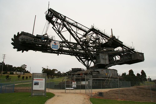
As well as a narrow gauge electric locomotive once used in the Yallourn open cut mine.

Then I went past Energy Brix briquette plant next door.
Which closed in 2014.
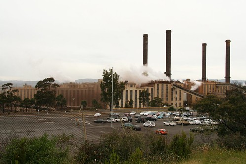
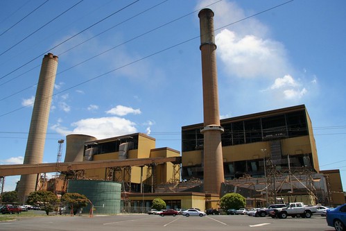
Then across to the Hazelwood power station.
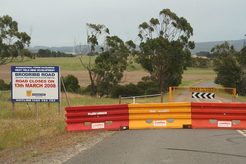
Back then the ‘West Field’ expansion of the open cut brown coal mine was underway, with a number of roads being closed to make room for the future hole.
But that effort didn’t really pay off – the aging dinosaur of a power station closed in 2017.
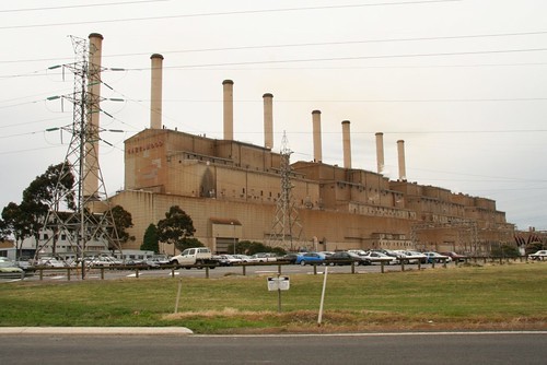
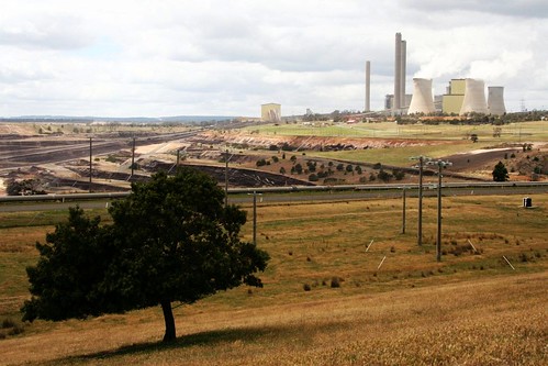
Still hanging on is the Yallourn W power station, completed in 1973-1982.
And the Loy Yang power station and and open cut mine.
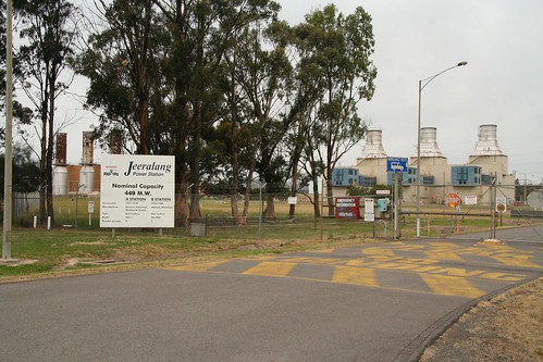
In addition to the slightly cleaner gas turbine plant at Jeeralang.
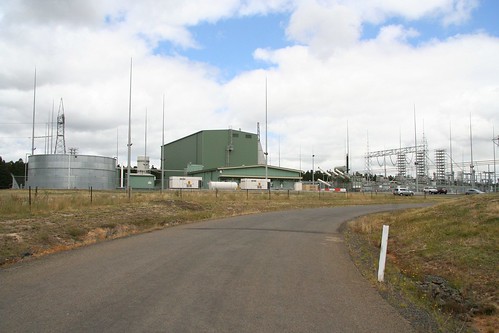
And an interesting piece of technology – the Loy Yang Static Inverter Plant, the Victorian end of the Basslink high voltage DC undersea transmission line that connects Tasmania to the national electricity grid.
Headed north
I then headed back on the trail of trains, heading over to Seymour where work had started on the gauge conversion of the railway north to Albury.

I also followed a special train operated by the Seymour Railway Heritage Centre to Tocumwal.

With Santa saving from the rear platform.

Captured a V/Line train passing the since removed mechanical signals at Kilmore East.

Passed the crummy facilities that passed for a station at Donnybrook.

And saw gravel being loaded into a train, ready to be transported by rail to concrete plants across Melbourne, instead of a fleet of trucks.

I then headed west, to photograph a V/Line train at Ballan station.

It won’t look like the above very longer – a second platform and overhead footbridge is now under construction.
I also stopped in at Deer Park.
Work on the Deer Park Bypass was underway, making it quicker for people in Melbourne’s west to drive towards the city, as well as for trucks transporting interstate freight.

But no investment was coming for Deer Park station. Once part of the main route between Melbourne and Adelaide, bidirectional signalling was provided so that faster moving passenger trains could overtake the far heavier and slower freight trains.

But only a gravel platform was provided for passengers, visited by a V/Line train every two hours, if that.

It took until 2015 for the poor level of service to be fixed, following the completion of Regional Rail Link.
But unfortunately the cost cutting to the project saw the bidirectional signalling removed, resulting in major delays to V/Line services every time a train breaks down in the section.
Two steps forward, another back?
Another place on the fringe of Melbourne’s urban sprawl is Diggers Rest, which back then was only served by V/Line services.

As was Sunbury, which saw a number of V/Line shortworkings terminate there in order to pump up the frequency to something worth using.

The $270 million electrification of the Sunbury line was completed in 2012, seeing suburban trains extended to the town, but but many of the locals weren’t happy – they preferred waiting around on a cold platform then ride a comfortable V/Line train.
And back to Geelong
Finally, we end close to home at Geelong.
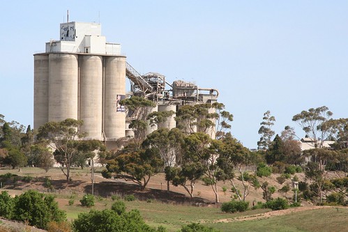
I visited the remains of the Fyansford cement works.
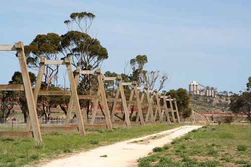
The silos were still in place.
As were the railway sidings once used to despatch the finished product.

But the cement kilns at the base of the hill were long gone.
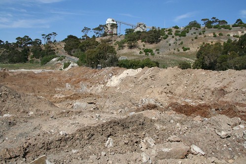
Today the silos are still there, but the tracks were removed in 2011, and the rest of the site redeveloped as houses.
I found a VLocity train bound for Marshall station, heading through an unprotected level crossing.

Rather than upgrade the crossing, in 2008 it was closed to vehicle traffic.
At North Shore I captured The Overland westbound for Adelaide.

The newly refurbished train had entered service in mid-2008 in an attempt to reinvigorate the dying service, but it doesn’t do much good – it was almost cancelled in 2015 following an impasse over funding, with it now set to end in 2018 after SA government declined to extended the arrangement further.
The rollout of ‘Parkiteer’ bike cages at railway stations had started, with South Geelong receiving one.

Platform extension works were also underway.

In September 2008 then Minister for Public Transport, Lynne Kosky, announced that longer trains would be deployed to the Geelong line, requiring platform extension works.
These trains continued to run until June 2015, when Geelong trains commenced using the new Regional Rail Link tracks and the trains were cut back to just six cars in length.
And finally after years of trying, I was finally in the right place at the right time and captured the daily V/Line overtaking move outside Geelong.

Until 2015 on the Geelong line, two V/Line services would depart Geelong each morning a few minutes apart. The first train would stop all stations, while the second train would run express to Melbourne, overtaking the slower train.
Finding this overtaking point was more art than science – even a 30 second delay to either train could move it a kilometre or so down the line, so all I could do was pick a spot lineside, and hope that I wouldn’t have to come back another day to try again.
Footnote
Here you can find the rest of my ‘photos from ten years ago‘ series.

Marcus,
is the Disused overbridge on Hazelwood Drive, Morwell, still in situ? I intend to get down that way soon and do a bit of camping and look over the abandoned infrastructure.
Regards,
Paul O’Connor
As far as I can tell from Google imagery, the bridge is still there today:
https://www.google.com.au/maps/@-38.2496275,146.4104623,168m/data=!3m1!1e3
But I haven’t been there since 2008.