In November 2015 the Andrews Labor Government announced another four level crossings in Melbourne would be removed – two of which are on the Cranbourne line. While any rail related upgrades are positive, from the information available so far it appears that the work will be just piecemeal upgrades that benefit road users, and not a holistic program to improve the transport network as a whole. So how could the Cranbourne line south of Dandenong be completely grade separated in a cost effective way?

Some background
The Cranbourne line south of Dandenong originally opened back in 1886 as part of the railway to South Gippsland, but it took until 1995 for the line to be upgraded to the current standards, when the section between Dandenong and Cranbourne was electrified and a suburban service was introduced.
The government has this to say in their media release spruiking the upcoming grade separation works:
The Andrews Labor Government has marked its first year in office by announcing that it will fast-track the removal of four more dangerous and congested level crossings.
Premier Daniel Andrews today joined Minister for Public Transport, Jacinta Allan, to announce that the level crossings at Melton Highway in Sydenham, Abbotts Road in Dandenong South, Thompsons Road in Lyndhurst, and Kororoit Creek in Williamstown North will be removed.
The removal of the level crossings announced today will reduce congestion, improve safety and create local jobs.
In 2012, Abbotts Road level crossing was the site of a horrific collision that derailed a train and resulted in one tragic death. The Labor Government will get rid of this congested death-trap once and for all.
Removing the Thompsons Road level crossing will eliminate a major congestion hot spot on this critical transport corridor in Melbourne’s growing south east. It will be delivered as part of the duplication of Thompsons Road, another key election commitment that will reduce congestion even further.
However the list of level crossings in the area is much longer:
- South Gippsland Highway, Dandenong South (on the Pakenham line)
- Greens Road, Dandenong South
- Abbots Road, Dandenong South
- Thompsons Road, Lyndhurst
- Camms Road, Cranbourne
And in addition, the Cranbourne line is still just single track – trains are only able to cross paths at Lynbrook station, which results in cascading delays and restricts the number of services able to operate on the line.

With all these problems, just removing two level crossings isn’t going to work – but thankfully the Cranbourne line has a number of ‘wildcard’ roads, that I will get to later.
Some ideas
The major cost of grade separation project is keeping both road and rail moving while the work goes on, combined with the rebuilding of any railway stations that happen to be nearby. But what happens if you look at the road network as a whole?
Grade separating the level crossings in Dandenong South is easy, because the work has already been done – a road overbridge at the Dandenong Bypass opened to traffic in 2007. All that needs to be done is close down the South Gippsland Highway and Green Road level crossings permanently – the alternate route over the tracks is less than a kilometres away, so motorists will hardly notice the extra minute or two it will take.
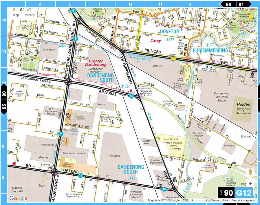
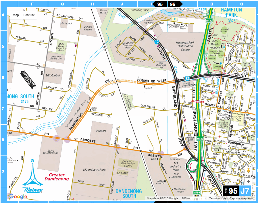
Next up: Abbots Road. Just looking at the Melway makes fixing this one really easy – just join the dotted lines! Here most of the work has already been done, with the westwards extension of Pound Road having been built in recent years, in conjunction with Remington Drive on the other side of the tracks. All that needs to be done is the construction of a road over rail bridge on the greenfields site, and the closure of the Abbotts Road level crossing.
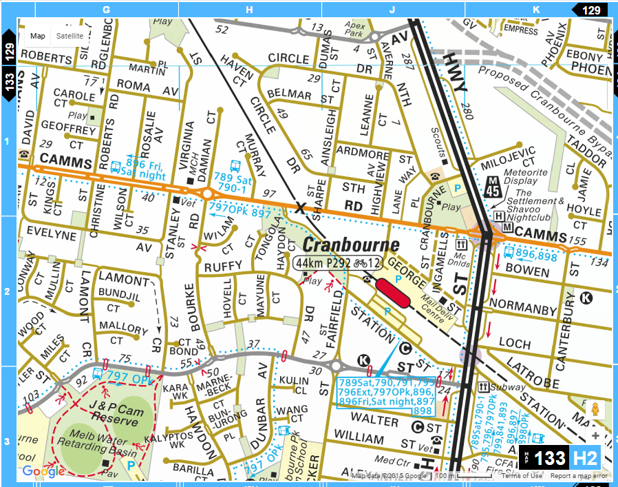
Down at Camms Road in Cranbourne is another simple level crossing to remove. Just close the road over the tracks, and upgrade Station Street along the south-western side of the railway line as an alternate route – no need to build a bridge!
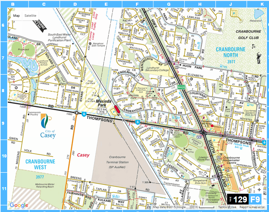
Thompsons Road is a little tricky – Merinda Park station is located a short distance to the north, so dropping the tracks beneath the road would require the station to be rebuilt, driving up the cost. However Thompsons Road is already a traffic sewer – the road could be raised over the railway on a new bridge, saving a bundle of cash, and nobody would be able to tell the difference.
The wildcards
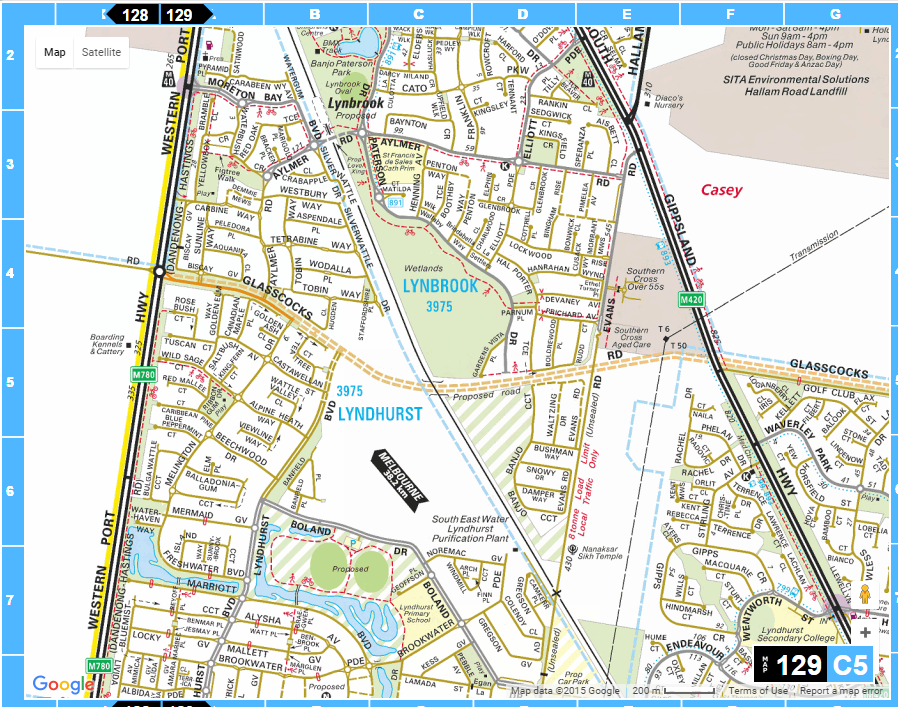
And finally – the ‘wildcard’ road links. At present there is no way to drive between the adjoining suburbs of Lynbrook and Lyndhurst, but lots of agitation for one.
Aylmer Road is the first proposed crossing – an east-west link that is currently a dead end on both sides.

The City of Casey wants the government to build a road underpass there:
Currently, Lynbrook and Lyndhurst communities are right next to each other but remain divided by the railway line.
The State Government’s own research shows that a road underpass can and should be built at the non-existent Aylmer Road rail crossing.
Lyndhurst residents have to drive about 10 km to take their children to school, access the Lynbrook shopping centre, medical centre, child care and church.
A level crossing at the Aylmer Road rail crossing has been planned since the early 1990s, however, changes in State Government requirements for railway crossings has resulted in a significant increase in the cost of delivering an Aylmer Road rail crossing – an underpass is now required.
The City of Casey is requesting that the State Government provides a funding commitment and constructs an $8 million road underpass at the railway line at Aylmer Road, Lynbrook. The City of Casey is prepared to contribute $1.6 million to the project, the equivalent of the previously proposed level crossing.
But I’m willing to bet that many residents would object to such a link, for the increased traffic it would bring to a currently quiet pocket of suburbia.
An alternative to Aylmer Road is the Evans Road level crossing – it runs north-south a few kilometres towards Cranbourne. Only one problem – it is closed to road traffic!

The level crossing at Evans Road long predated suburban development of the surrounding area, but development is what led to it closing – the City of Casey temporarily closed the unsealed section of the road in 2005 due to safety concerns, and it has remained closed since, despite the road having been sealed in the meantime.

It seems like a complex problem, but the City of Casey’s ‘Lynbrook & Lyndhurst Development Plan‘ has a simple answer:
Development of Glasscocks Road as an east-west arterial road linking the Western Port Highway and Clyde Road, that will create future access opportunities to the Dandenong South area and the broader metropolitan south east region.
It might not sound like much, but when you see it on the Melway, it all makes sense.
Pretty simple – five existing and two potential level crossings eliminated, with only three new bridges having to be built, only one of which has to be constructed on an existing roadway. With all of the money saved and the entire line grade separated, there should be plenty of funding to duplicate the Cranbourne line tracks, and deliver some returns to rail passengers!
‘But you can’t just close roads!’
Riddle me this – when VicRoads builds a new freeway, they don’t build a bridge for every little goat track that crosses the new freeway – main roads get an interchange, and the minor roads get cut off. So why should a rail upgrade program be forced to blindly retain the existing network of roads?

Closing Greens Road which is a major arterial road is not a sensible option.
Other closures like Abbotts Road could be temporary when the new bridges are opened to give a “greenfields” area to build another bridge.
Really the project should be duplication of the railway with all effected roads grade separated.
Greens Road is signposted as part of ‘State Route 12’ from Mordialloc to Narre Warren – for someone travelling end to end, the alternate routes are not as direct:
https://www.google.com.au/maps/dir/-38.0086327,145.1151164/-38.0291465,145.3010854/@-38.0152722,145.2015788,13.25z/data=!4m14!4m13!1m10!3m4!1m2!1d145.2115721!2d-38.0142234!3s0x6ad613c46b2a3b03:0x13045674ec4704e0!3m4!1m2!1d145.2278513!2d-38.005899!3s0x6ad61158384b1c4f:0x13045674ecff80f1!1m0!3e0
Even if the Abbotts Road – Pound Road was constructed:
https://www.google.com.au/maps/dir/-38.0086327,145.1151164/-38.0291465,145.3010854/@-38.0335884,145.2137898,12.75z/data=!4m14!4m13!1m10!3m4!1m2!1d145.2115721!2d-38.0142234!3s0x6ad613c46b2a3b03:0x13045674ec4704e0!3m4!1m2!1d145.2305916!2d-38.0339233!3s0x6ad61178a98ed129:0x13045674ec55be30!1m0!3e0
Google Maps makes it easy to validate your ideas without even visiting an area in peak times – set your departure time to around 4:30pm/5pm and you’ll note the red congestion in the vicinity of Abbots Rd and Greens Rd as it is.
As Anthony suggests, there is no enough roads in the area to funnel traffic coming from Braeside / Dandenong / Monash / City etc heading home to the growing suburbs around Cranbourne and beyond to South Gippsland. i’ve sat on the 892 bus through there a few times to know its a nightmare and something to avoid.
Reopening Evans Rd, after joining it directly onto the end of Hallam Rd would at least give another option for some people.
Of course, the elephant in the room in all this problem is there is no alternative to driving for many people who work in the vast industrial blocks of Dandenong South or further afield – other than lack of stations in the industrial area, there a few bus options close by to many sites, and those that do exist are designed to transport workers into Dandenong – someone living in the outer fringes is unlikely to want to backtrack towards Dandenong in order to return home to Cranbourne. Even moderate solutions like an east-west bus between Mordialloc and Fountain Gate are ignored.
Duplicating the line has it’s benefits, and is overdue, but won’t solve one of the key transport issues for that part of Melbourne – and your suggestions only make life worse for those people who have little other choices but to drive in peak hour traffic.
Good points around the difficulty serving the dispersed industrial areas of the south-east, and thanks for the Google Maps traffic data tip (I’d forgotten all about that one).
While yo do have some points to be debated.. The suggestion of greens rd being closed is absolutely ridiculous! Have you lived in the area? That road sees thousands of vehicles each day from trucks to cars.. Drive from Mentone to lynbrook in the evening peak & it can take 40mins from greens rd to lynbrook as it is. There is not enough Ross to get past Dandy Sth.. Only Princes Hwy and Pound Rd.. Drive those roads in peak hour before making crazy statements…
The only option is to lower the rail line underneath at Greens Rd.. Or bridge the rail above.. No station in the area so yes as you’ve said it won’t cost as much as a full redevelopment.
Evans Rd also can only be opened if a major intersection development occurs on the north end where it meets the Sth Gippy/ Hallam Rd as hundreds will use Evans rd to get from Cranbourne west to the top of Lynbrook/ go to Hallam.
I lived in that area for 4 years & it is not as simple as you claim it to be.
I think there is a case for a Station for Dandenong South at Greens Rd because of the employment density in the area. Some of the people working locally and living on the Cranbourne Line (including the city Dandenong section) would switch to rail or bus and rail.
I only visit the area a few times a year, and only on weekends, so I’ll defer to your knowledge on that front.
Though I do agree with how horrible the South Gippsland Highway / Hallam Road intersection is – I tried to turn right out of there once, and was waiting an eternity!
Closing the Dandenong Rd end of the South Gippsland Highway by closing the level crossing is a good idea. However expect the road lobby to try and claim that the South Gippsland Highway-South Gippsland Freeway section of the Dandenong Bypass/Dingley Arterial needs to be built for this. However provision shoul still be made for pedestrians to cross at this location.
If the Cranbourne Line is to be level crossing free then Cranbourne will need lowering to extend the line to Cranbourne East or preferably Clyde (the urban growth boundary). The same would apply with reopening the South Gippsland line.
Thompson Road is already a very busy east west route and has already been earmarked for duplication with grade separation of the rail and an interchange at Westernport Highway where traffic banks up at the existing roundabout during the PM peak much worse than the level crossing further on does (Westernport Highway is proposed to freeway standard down to Canbourne Frankston Road eventually)
As you said any works really should be tied in with track duplication work – presumably they intend taking the suburban line to Clyde where they are currently building houses. Some of these outer roads in wider reservations particularly in industrial areas really should involve moving the road over/under the rail line – at the moment they are rebuilding the station, rail,car parking, bus facilities and all at the cost of the best part of $200 million for effectively a single intersection.
Furthermore Caulfield to Oakleigh (where they will be certainly moving the rail) at a minimum should have full provision for four tracks to avoid effectively killing off a Rowville rail line in the future.
The work at Thompsons Road sounds much like the work VicRoads did to Kororoit Creek Road back in 2011 – duplicating the road and grade separating the level crossing with the Werribee line, at a total cost of $48.5 million:
https://www.railpage.com.au/f-t11355092.htm
Another similar project was Somerton Road – again, duplication and construction of a road over rail bridge in 2008, at a cost of $33.7 million:
http://cdn.projectlink.com.au/news/premier-opens-somerton-road-upgrade
Both crossings were built in the same way: the bridge for one carriageway was built beside the existing level crossing, traffic was moved onto it, then the level crossing removed, and the second bridge completed.
https://www.railgeelong.com/gallery/geelong-line/kororoit-creek-road/
Of some interest: South Gippsland Hwy at Cranbourne is, technically, still an active crossing. It is at least maintained in working order and periodically tested. This is despite no rails above bitumen.
.
The rails beneath the bitumen would still form the circuit to the traction substation on the other side – sounds like fulfilling bureaucracy there. Ironically the overhead was removed across the crossing and also fed underground to over the stabling yard
The suggestion made is as long as they keep the crossing active, regardless of trains using it or not, they leave open the option to reopen the line to Cranbourne East and Clyde with at grade crossings.
As we saw with South Morang, Regional Rail Link and now Mernda, both sides of state government have largely agreed to a policy of no new level crossings in the metro area – this means that a road that might only carry 2000 or 5000 cars a day will get a grade separation if it’s decided the link must be kept open.
Of course, it’d be madness to have traffic travelling to South Gippsland were forced to cross the line at grade, and hopefully we’ll see a grade separated option, whether it is the crossing at Cranbourne Station done, or the long talked about bypass road
Cranbourne East should have been built over a decade ago. It is much needed.
Building a grade separation when the crossing is initially built is much more efficient than going back later to grade separate. I believe the no new level crossings policy is state-wide.
I am sure that the South Gippsland Highway will be grade separated at Cranbourne eventually.
I am fairly sure that the Cranbourne Bypass is unlikely to be built in the foreseeable future. In times past it would have avoided most to all of the bellow 100km/h sections of the Highway but it is now 80km/h all the way to the South Gippsland Freeway and the development is soon to encroach on the Highway beyond the end of the Cranbourne Bypass reservation and as such the only lower speed section bypassed would be the short section of 60km/h through the Cranbourne shops. There is no reservation for the Cranbourne bypass to connect to the existing Freeway or even its planned future extension along the Westernport Highway. The bypass reservation is now surrounded by housing on all sides and thus there would be some complaint about its construction. And the clincher is that the Highway through Cranbourne is decreasingly the primary route to South Gippsland because, since the Pakenham Bypass opened, the traffic has cut across to the Princess freeway as that is a faster route and Koo Wee Rup has thus been bypassed because of the increase in traffic and the plan is to eventually upgrade Healesville-Koo Wee Rup Rd to freeway standard as far as the Pakenham bypass, completely avoiding Cranbourne.
Good point about the Cranbourne Bypass – I’ve given up on it as a route to Phillip Island, and switched to the Koo Wee Rup Bypass instead.
Google Streetview from January 2008 still shows the overhead in place, but covered tracks:
https://www.google.com.au/maps/@-38.1007299,145.2826382,3a,75y,155.34h,80.6t/data=!3m7!1e1!3m5!1sMjuqnT_5s7nWQziZsdiDMw!2e0!5s20080101T000000!7i3328!8i1664
With the new stabling yard being commissioned in October 2008:
http://vicsig.net/infrastructure/location/Cranbourne
I have had to go to a job interview on Greens Rd without a car a couple of times. It is a long way from the station. One day it was so hot the place where I interviewed felt sorry and gave me a lift back to the station. There would be a lot of apprentices who would have to catch the bus or get picked up from Dandenong station currently.
Some quick replies I have to the above. As I lived in Cranbourne from 1986 to 2000, I have some history with the area. Now living in Narre Warren, I am not that far from Cranbourne today.
#1, the overhead across the South Gippsland Highway was cut a few years back, and no longer crosses over the highway.
#2, Yes, the line needed to be extended to Cranbourne East, for the Civic Center many years ago.
#3, There is urgent need for a new station at Greens Road. There are three bus routes at different cross roads with Greens road, including along the South Gippsland Highway right near the railway line.
#4, many in local council where very keen on the Cranbourne bypass road, and land is held in reserve for just such a road to be built. But, as said above, most of the traffic now goes via Pakenham.
#5, Thompsons road was a popular route for me to get home from my old haunt of Keysbourgh. It was a very busy road back then, and does need duplication.
#6, I can not believe there is still now traffic lights on the Hallam road corner. To link up Hallam road and Evans road, would make a great major road to run between Hallam and Pearcedale.
Closing Greens Rd and even Abbotts rd isn’t the greatest idea. There is quite a bit of traffic that goes both ways every day. You can just see how much when an accident occurs or the boom gates play up. My normal trip to work only takes about 15 minutes. If somthing does happen it can easily blow up to beyond 30 mins. last time the boom gates at Greens rd played up it took 10 minutes alone just to turn into the South Gippy from Pound Rd.
Abbotts rd is now more or less used as a rat run so people don’t go down Greens Rd. Although now it too filled with traffic as well.
February 2016 update – the Level Crossing Removal Authority is keen on the “close the Abbots Road crossing and extend Pound Road over the tracks” idea:
http://www.theage.com.au/victoria/wrong-way-turn-back-anger-at-plan-to-shut-busy-road-to-remove-level-crossing-20160228-gn5oya.html
[…] there is a level crossing that never existed – an east-west road proposed in the 1990s that was never completed, and never will be due to a policy of no new level […]
[…] (Marcus Wong has a good blog post with some detail on the Cranbourne line crossings.) […]