The post Photos from ten years ago: December 2014 appeared first on Waking up in Geelong.
Post retrieved by 192.0.91.24 using wp.com feedbot/1.0 (+https://wp.com)
]]>On the train
Yes, still on the Regional Rail Link topic – Ballarat and Bendigo trains now had their own tracks through Footscray to Sunshine, along with their own next train displays located away from the ones showing suburban trains.
But for now Geelong line services were still running along the Werribee line. Here we see a N class locomotive hauled train passing through Williams Landing.
A VLocity train passing through Laverton station.
And another passing through the platforms at South Kensington.
Which then took the crossover at the city end of the station to access the new V/Line tracks towards Southern Cross.
Freight trains
A decade ago Pacific National still had the contract to transport grain by rail to the flour mill at Kensington. Southern Shorthaul Railroad won the contract in November 2017.
Meanwhile down at North Geelong Yard Pacific National was busy scrapping surplus wagons – the bulk of which once transport freight that has been lost to road.
Down around Geelong
The North Geelong B signal box was still hanging around a decade after it had been decommissioned in 2005, and surprisingly it hung around almost a decade longer – eventually being demolished in May 2022.
While down in Grovedale money was getting spent on Baanip Boulevard, with a new bridge being built over the railway to link the Geelong Ring Road to the Surf Coast Highway.
And down at North Shore even the dive of a station was getting some attention – new asphalt!
Ding ding on the trams
Remember the ‘Melbourne Star’ observation wheel? This tram was advertising it, before the operator went broke in 2021.
But a tourist icon that people actually patronised was the Colonial Tramcar Restaurant – it ran until 2018 when their restaurant trams were kicked off the Yarra Trams network due to safety concerns.
Another safety concern that is having to dodge cars to climb onboard tram at South Yarra station. The platform stop there wasn’t opened until 2021.
Another crappy tram stop was the one at La Trobe and Swanston Street – on this December afternoon it was overwhelmed by a crowd of RMIT graduates spilling out onto the road. Platform stops were not provided along La Trobe Street until July 2024.
And continuing on that theme, now we’re at Collins and Queen Street – closed in 2015 following completion of a new platform stop at Collins and William Street.
Another stop to close being the one for southbound route 96 passengers at the corner of Spencer and Flinders Street.
Works about to start on new platform stops at Batman Park a short distance to the south.
A few buses
A decade ago route 400 between Sunshine and Laverton was operated by plain white liveried buses – an artifact of the shared operation of the route between Westrans and Sita. Today the operations are now CDC Melbourne and Transit Systems, and the white buses are gone – they’re mostly PTV orange, with the exception of a few buses still in the old poo brown Sita corporate livery.
Another oddball bus was the British-built Optare Solos used on the SkyBus hotel shuttle service around the Melbourne CBD. Later branded as ‘SkyBus Link’, the service was discontinued in 2020 thanks to the Covid-19 pandemic, and never restored.
And the last bus is a Designline ‘bubble’ bus running on route 903 along Bell Street in Coburg.
Stuck in traffic waiting at the level crossing with the Upfield line – which was removed in June 2020.
Ticketing bits
Down in Geelong it was once possible to buy a ‘Short Term Ticket‘ from bus drivers rather than use a Myki card – an option removed in April 2013.
While in the lead up to the November 2014 election both parties promised to cap Melbourne suburban travel to zone 1 prices, and introduce the ‘Free Tram Zone’ in the CBD.
Both starting from 1 January 2015.
But don’t think they’re giving you something for nothing – PTV was simultaneously running yet another fare evasion campaign.
As well as promoting free travel on Christmas Day.
Car parking
What’s a worse use of prime CBD land than a ground level car park? This is the ‘Golden Square’ car park at 217 Lonsdale Street, which is still a car park today.
And this is the ‘Safe City Car Park’ at 132 Little Bourke Street in Chinatown – which has since been turned into a pop up event space.
And finally – a power station
Here we are at the main gate to Anglesea Power Station.
Located in the middle of the Anglesea Heathlands.
Next to a brown coal mine.
Opened back in 1969 to power Alcoa’s Point Henry smelter outside of Geelong, the smelter was closed down in July 2014 but the power station remained open pending a new owner, before it too was shut down in August 2015.
Footnote
Here you can find the rest of my ‘photos from ten years ago‘ series.
Post retrieved by 192.0.91.24 using wp.com feedbot/1.0 (+https://wp.com)
The post Photos from ten years ago: December 2014 appeared first on Waking up in Geelong.
]]>The post Cooked next train displays at Southern Cross Station appeared first on Waking up in Geelong.
Post retrieved by 192.0.91.24 using wp.com feedbot/1.0 (+https://wp.com)
]]>Yep, it’s cooked
Three out of the seven displays are barely visible – leaving the next seven V/Line departures MIA, along with the entire list of V/Line arrivals, and all services on the Cranbourne, Pakenham and Frankston lines.
But luckily you turn around and find a second set of screens – only to discover half these ones are also broken – you can now see the Cranbourne, Pakenham and Frankston lines; and the V/Line arrivals are nice and bright; but the Lilydale, Belgrave and Glen Waverley line are gone.
And the next seven V/Line departures – if you squint hard, you might just be able to read them on the faded screen.
And don’t hope on walking over to the platforms either – the screen at the top of platform 11 and 12 was also hardly visible.
As was the one above platform 15 and 16.
But why?
The reason for the screens not working? The screens aren’t broken outright, as they work most of the time.
The clue being in tiny text in the corner of the screen – ‘TEMPERATURE WARNING!!’. I photographed the failing screens on December 5th, when the top temperature was 33.2 °C, and that was enough for the the screens to be unable to cope.
I found a similar warning on one of the platform screens on February 4th – when the top temperature was 37.5 °C.
So in theory a simple fix – but the management at Southern Cross Station can’t even change a light bulb.
And they aren’t that old
You might point the finger at the screens being old, but that isn’t exactly true – for years Southern Cross Station used a ‘temporary’ array of CRT television screens to display the next suburban train departures.
The permanent LCD screens not being switched on for suburban trains until March 2009.
Allowing the ‘temporary’ screens to be covered up.
Until they were finally removed in April 2010.
And the LCD screens didn’t last long anyway – they were removed in November 2012 for “maintenance”.
Out of service from November 12 to December 23 – that’s 41 days to change eight screens!
Footnote: another other things cooking in the heat
Melbourne’s Comeng suburban trains from the 1980s also once had a reputation for failing in the heat.
The air conditioning failing once the temperature reached 35 degrees.
So after a spate of failures during the summer of 2008-09, the decision was made to upgrade the air conditioning units fitted to said trains.
And lo and behold – they’re just as reliable as newer trains in hot weather.
Post retrieved by 192.0.91.24 using wp.com feedbot/1.0 (+https://wp.com)
The post Cooked next train displays at Southern Cross Station appeared first on Waking up in Geelong.
]]>The post Bolt down bike hoops are useless appeared first on Waking up in Geelong.
Post retrieved by 192.0.91.24 using wp.com feedbot/1.0 (+https://wp.com)
]]>As all a bike thief needs is a shifter to unbolt it from the ground.
And ride away with the bike that was locked to it.
It’s the reason why they say put your bike lock through the rear wheel *and* the frame.
A U-lock can go around the rear rim and tire, somewhere inside the rear triangle of the frame without looping it around the seat tube: the wheel cannot be pulled through the rear triangle. A lock which passes around a rim makes the bicycle unrideable even if the object it is locked to can be broken or disassembled.
Because cutting up a bike defeats the point of trying to steal it.
Some people will object that felons might cut the rear rim and tire to remove a lock. This just doesn’t happen in the real world. It is possible to cut the rim with a hacksaw, working from the outside to the inside, but first, the tire must be removed or cut through. It would be a lot of work to steal a frame without a usable rear wheel, the most expensive part of a bike after the frame.
What makes these particular bike hoops egregious was that they installed as part of the Regional Rail Link project a decade ago along with the concrete path, so it isn’t even “boring holes was too hard” – they could’ve embedded the bike hoops into the concrete when pouring it.
And retrofitting concreted in bike hoops isn’t that hard – you just need a core drill.
There is your hole.
Pop out the paving.
And you’re all done.
And it’s not the first time
Did you notice anything odd about the row of bike hoops in my lead photo?
Yes, they’re all brushed metal except for one with a galvanised finish – presumably a replacement after another bike thief unbolted the previous hoop.
Post retrieved by 192.0.91.24 using wp.com feedbot/1.0 (+https://wp.com)
The post Bolt down bike hoops are useless appeared first on Waking up in Geelong.
]]>The post Then and now along the West Gate Freeway appeared first on Waking up in Geelong.
Post retrieved by 192.0.91.24 using wp.com feedbot/1.0 (+https://wp.com)
]]>
PROV image via West Gate Tunnel Project
Approaching the Lower Yarra Freeway
We start on the Prices Highway way back in 1969, one mile away from the junction with what was then called the ‘Lower Yarra Freeway’.
VicRoads photo, via West Gate Tunnel Project
And the view today – the ‘Lower Yarra Freeway’ is now called the West Gate Freeway, the Princes Highway via Footscray is now the secondary route, the two lanes have doubled to four, and the Western Ring Road has been added to the junction.
And the changes can also be seen at the freeway junction itself.
VicRoads photo, via West Gate Tunnel Project
Dohertys Road over the freeway having been duplicated in 2021, with more lanes underneath to come as part of the West Gate Tunnel Project.
On to Williamstown Road
We now move onto this 1970 view from the West Gate Freeway at Williamstown Road – an ‘End Freeway’ sign attached to the footbridge – the West Gate Bridge having collapsed during construction on 15 October 1970, with the death of 35 workers.
VicRoads photo, via West Gate Tunnel Project
And the view today with a completed bridge, and changes thanks to the West Gate Tunnel Project – tall concrete noise walls, the Woduyullul Parring footbridge completed in 2020 to replace the previous open air footbridge; and small footprint steel monopole towers that replaced the traditional lattice towers supporting the 220 kV transmission lines.
Onto the bridge
No traffic in this view of the West Gate Bridge before it was officially opened.
VicRoads photo, via West Gate Tunnel Project
But the main difference today – the suicide barriers hurried erected in 2010 after years of the government refusing to do so.
Check out the view!
And here is the view from the top, looking over to the Melbourne CBD.
VicRoads photo, via West Gate Tunnel Project
With 40 years of development filling out the skyline.
And down below
Headed through Port Melbourne
We start off at Graham Street interchange in Port Melbourne, with this 1983 view looking west towards the West Gate Bridge.
VicRoads photo, via West Gate Tunnel Project
And the view today – the trees are taller and the ‘UFO’ lights are gone, and more importantly, Graham Street doesn’t traverse the bridge anymore. Instead the bridge forms the connection between the Bolte Bridge and the West Gate Freeway, with the Graham Street severed in 1997 so that construction of the CityLink project could proceed.
And over South Melbourne
Now we are in 1987, and it is opening day of the first stage of the elevated West Gate Freeway extension through South Melbourne to St Kilda Road.
VicRoads photo, via West Gate Tunnel Project
While the view today shows the connection through to CityLink completed in 2000, and additional lanes added in 2011 as part of the Monash–CityLink–West Gate Upgrade project.
Footnote: a bonus bridge
And here’s a 1971 photo of workers having a smoko beneath the Grieve Parade overpass.
VicRoads photo, via West Gate Tunnel Project
In 1991 the original bridge was widened as part of the duplication of Grieve Parade – the original two lane span being joined by another four lane bridge to the west side.
But the heavier trucks of today were too much for the original bridge to handle, and so in January 2021 the spans were demolished as part of the West Gate Tunnel project.
The eastern half rebuilt with stronger concrete super-T beams, and the earthen embankments cut back to fit more traffic lanes beneath.
Post retrieved by 192.0.91.24 using wp.com feedbot/1.0 (+https://wp.com)
The post Then and now along the West Gate Freeway appeared first on Waking up in Geelong.
]]>The post The saga of lifts at Watergardens station appeared first on Waking up in Geelong.
Post retrieved by 192.0.91.24 using wp.com feedbot/1.0 (+https://wp.com)
]]>In the beginning
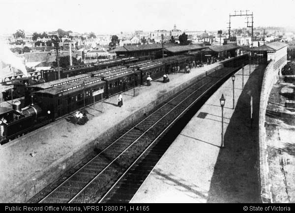
For years Sydenham station was a wayside stop on the empty plains north-west of Melbourne enroute to Bendigo.
But the suburbs of Melbourne eventually grew north to Sydenham, and so in 2000 the decision was made to extend suburban trains from St Albans five kilometres north to a new station called ‘Watergardens’.
Which opened in 2002.
The new terminus was well provisioned for a terminus station – three platforms, with centre turnback for terminating trains.
Sidings at the down end for stabling trains to form peak services.
Three lifts – one of the street on both sides, and a third to the central island platform.
With stairs in parallel.
However the footbridge across the tracks is narrow compared to what stations have today.
And the lifts were undersized compared to current standards – of 12 person capacity rather than 18.
But the lifts don’t work
As Watergardens station aged, the lifts weren’t exactly the most reliable – from 2016:
A malfunctioning lift at Watergardens train station that reportedly breaks down nearly every second week, on average, is likely to be replaced.
Western Metropolitan MLC Bernie Finn told state parliament recently the Watergardens lift had broken down 43 times over the past two years, and sometimes took a week to fix.
“For people to have to wait for up to a week for a broken down lift to be fixed seems to me to be quite insane. That is just ridiculous,” he said. “It is a major concern, particularly for people with disabilities and for elderly people.”
Public Transport Victoria and Metro Trains have been forced to provide maxi taxis for special needs commuters, who could not access the train to get to doctors’ appointments.
Mr Finn has also called for a second ramp to be built to service both sides of the station.
“I find it just astonishing that we have a lift there that has broken down so often. There is only one ramp for people to use, and it is on the opposite side of the platform,” he said.
“I just do not understand how the PTV could allow such a situation to exist.”
A PTV spokesman said it would continue to provide “alternative transport arrangements” for passengers when lifts are out of order.
“PTV is committed to finding a permanent solution for passengers – which at this stage could involve replacing the lifts,” he said.
Lift failures rendering stations inaccessible being the reason why the trio of stairs, lifts and long zig-zagging ramps with a DDA compliant 1 in 14 gradient has became the standard at new and upgraded railway stations in Melbourne from 2013.
But in the case of Watergardens station it was too late for that, so the only option was to upgrade the control and power supply systems for the existing lifts to improve their reliability – requiring one outage from 1 to 5 May 2017, and a second from 18 September to 3 November 2017.
And spending the big money
But even upgraded lifts can still fail, so in 2016 PTV commissioned Jacobs Group to study possible options to bring Watergardens station up to current standards, and provide a redundant method of access if the existing single lift to a platform failed.
They looked at going under, over and through the tracks. As you might expect, building a new level crossing got knocked on the head pretty quickly, and going under option was less than salubrious, so also got knocked out.
This left three options to upgrade the existing overpass – duplicating the three existing lifts, providing a ramp beside each lift, or a hybrid option with a additional lift to the island platform and two ramps to the street entrances.
Fitting in the new ramps on the street site was easy.
Artist’s impression, Jacobs 2016
But the island platform was more constrained, with a DDA compliant ramp taking up much the space at the Melbourne end.
Artist’s impression, Jacobs 2016
The Jacobs report also looked at the costs of the three options:
3.2 Constructability and Whole of Life Costings
An estimate of the turn out and life cycle cost for the 3 options – out to 30 years – is attached as Appendix D.
In precis, the full lifts option is the cheapest in the short term, the full ramps the most expensive:
Option 1 – All Lifts $5,276,700.00 – immediate Capital Construction Cost.
Option 2 – 2 ramps + 1 lift $5,595,000.00 – immediate Capital Construction Cost.
Option 3 – All ramps $6,568,200.00 – immediate Capital Construction Cost.When factoring in the costs to service and maintain each option for 30 years (non-discounted cashflow) the costs become:
Option 1 – All Lifts $9,868,230.00 – adding $4,591,530.00 (non-discounted $s) in costs over 30 yrs.
Option 2 – 2 ramps + 1 lift $7,661,793.00 – adding $2,066,793.00 (non-discounted $s) in costs over 30 yrs.
Option 3 – All ramps $7,632,994.00 – adding $1,064,794.00 (non-discounted $s) in costs over 30 yrs.For the first 10 years Option 1 has the lowest WOL cost.
Between year 10 to year 29 Option 2 has the lowest WOL cost.
After 30 years Option 3 has the lowest WOL cost.
Surprisingly the lift option was cheaper to build initially, through obviously the ramps became cheaper once ongoing maintenance costs were included.
Decision time
The 2018-19 State Budget committed $8.9 million to upgrade Watergardens station, with community consultation taking place in July 2018.
But there was a problem – the preferred option was installing additional lifts, but the PTV Network Technical Standards at the time required lift, stairs and a ramp for a vertical change of 5.6 metres – and so a waiver was required to provided a second lift, as well as to infringe on the minimum platform width where the new lift would land on the island platform.
However a waiver was granted, and work started on the project in early 2021.
The new lifts being located in plain grey towers, beside the existing brick ones.
An additional lift added at the end of the western entry.
And to the eastern entry.
While the additional lift to the island platform was snuck in beneath the existing concourse.
The stairs to the platform rebuilt.
To pass around the new lift shaft.
Which looks like it was always there.
PTV having this to say about the upgrade.
We have opened three new lifts at Watergardens Station to help people move around the station precinct and catch the train more easily.
This is part of the Public Transport Accessibility Improvements Program, which sees several metropolitan train stations upgraded to comply with current access guidelines for people with disabilities.
The new lifts feature:
- more space to increase lift capacity and allow for social distancing
- improved lighting
- a back up power supply, making them more reliable and avoiding breakdowns
- improved security with new CCTV coverage and windows
- more open design than the existing lifts with partially transparent lift walls.
Other completed works at Watergardens Station:
- We have increased the number of wheelchair accessible parking spaces in the Sydenham Road car park from five to nine.
- A back up power generator has been constructed to help power the lifts and station in the event of a blackout.
- Six extra CCTV cameras have been installed to cover blind spots around the stairs.
- Toilet refurbishments have been completed on the central platform and concourse to improve passenger amenities.
- New tactile ground surface indicators have been installed on all three platforms to improve accessibility.
A lot of work for a railway station only 20 years old!
Footnote: ramps vs lifts
Back in 2016 the Level Crossing Removal Authority also had to fight to avoid building massive ramps as part of the Mernda rail extension, but since then it seems to be a non-event – most new stations built since then feature dual redundant lifts to each platform, rather than ramp and a lift.
Footnote: platform extensions
The 2016 Options Report by Jacobs touched on the need for platform extensions at Watergardens station for the upcoming fleet of High Capacity Metro Trains, and flagged at changes at the city end would be the logical option.
1.5 Provision for other works – Future 10-car HCMT
Possible options should consider other works that may occur at or around the station in the future. The most important of these – in fact, the only one known to Jacobs – is the platform extensions for the new 10-car High capacity Metro trains (HCMT).
Currently the 3 platforms are 160 m long. The island platform is approximately.8.9 m wide at the down end; tapering on the Platform 3 side to c.7 m at the up end. All platforms will require an extension of 70m to bring them 230 m and, depending upon where this extension occurs, Platform 3 may need straightening.
Informal advice from PTV indicates that it is likely that it would be simpler and less costly to extend the platforms toward the city.
Jacobs’ own study of aerial photographs indicates that the gates to the stabling yards down from the station are c. 200 m from the NW end of the platform and that there are at least 7 sets of points in this area. The corridor to the SE is significantly less congested with 5 sets of points within c.250 m of the station after which it appears to be completely unencumbered until it reaches the next station at Keilor Plains.
For these reasons it seems most likely that the platform extensions would occur to the SE (up end); widening Platform 3 to remove the existing taper to provide an island of consistent width for its full length. Although the platform extension has no immediate bearing on the provision of secondary (or contingency) means of access to and from the station, as the widening would create additional space on the platform that would ease a pinch point in one of the options (see below), an up end extension to the platforms has been presumed in the development of the options..
And then look at what happened in 2022 – the entire lead into the yard at the down end of Watergardens was rebuilt.
Platform 1 extended by 15 for a 7-car HCMT.
And platform 2 and 3 extended by an even shorter 12 metres.
They also completed a major track slew at the down end of the yard at Watergardens, taking the sidings from 329 metres (two 6-car trains) long to 560 metres (three 7-car trains) long.
Footnote: the gory technical details
First – the options study by Jacobs.
Watergardens Accessibility Study
Options Study
December 2016Watergardens station was designed and constructed between c. 2000 – 2002. The station was officially opened in January 2002.
The design provided for a single lift and stair access only to and from the island platform and the adjacent streets on either side of the station. However, the lifts have proved to be unreliable and, for those unable to use the stairs, access and egress to and from or across the station from either side has been made difficult.
With this in mind, PTV commissioned Jacobs to carry out an Options Study to draw out such options as might exist to provide a secondary means of access from one side of the station to the other and to the station’s central island platform for those unable to use a flight of stairs
The station contains 3 platforms – Platform 1 to the NE on the shopping centre side of the line and platforms 2 and 3 forming an island platform. Access to Platform 1 is made by one of two sets of stairs – one of 12, the other 13 risers – or one of two ramps – rising from the kerbside footpath. From the level of Platform 1 access is provided to the concourse level (c. 5600 mm above Platform level) by means of a lift or stair of 33 risers (two flights – of 17 and 16 risers).
From the SW side of the line, access to the station is made at concourse level. This is some 7000 mm above the pavement level, with access provided by means of lift or stairs. This stair consists of two flights – of 20 and 21 risers – 41 risers in all.
From the concourse access is provided to the island platform by lift and stair of two flights.
Looking at going under, over and through the tracks.
2. Options
Based upon the limitations noted above, there are three basic approaches – to cross the rail line / gain access to the platforms:
– At grade
– Under the permanent way
– Over the permanent way
As you might expect, building a new level crossing got knocked on the head pretty quickly.
2.1 Options – At-grade
Whilst recognising that both pedestrian and vehicular at-grade crossings both are, as a matter of PTV guidelines, no longer considered suitable, for completeness the possibility of at-grade options has been considered.
An at-grade point of egress has been provided at the down (NE) end of the island platform. This was previously used to provide emergency egress for the mobility impaired from the platform to the kerb-side on Sydenham Road, but the practice has since been discontinued. Presently, in the event of a lift failure, mobility impaired patrons are re-entrained and taken to the nearest accessible station from whence they are returned to Watergardens by taxi.
The ramp is still used by the Train drivers to access the stabling yard down line from the station.
In discussion with PTV and MTM at an initial Stakeholder consultation, it was agreed, for the above reasons and more, that an at-grade option is not feasible and was not pursued as a viable design option.
The going under option was less than salubrious, so also got knocked out.
2.2 Options – Under the permanent way
One underpass option was considered.
This is based upon using ramps of a maximum length of 6000 mm at an inclination of not more than 1:14 (one metre rise over 14 metres of length). Landings of not less than 1200 mm length are provided between each section of ramp. Larger landings are provided at changes in direction.
The scheme provides a straight ramp (of 10 x 6000 mm sections) descending from ground level adjacent the existing lift and stairs on the SW side of the station to a horizontal underpass lying c. 5600 mm below the level of the platform.
This ramp runs through the area currently used as a retention basis for storm water runoff from the adjacent carpark.
From the bottom end of this ramp, the underpass runs under Sydenham Road and the up end of the platform to emerge on the NE side of the lines with a switchback ramp (of 8 x 6000 mm sections) in an open area between the Telstra communication tower and existing station ramps. This delivers users c.60 m to the south of the existing station entry. The underpass is c. 50 m long.
A third ramp (of 13 x 6000 mm sections) runs from the mid-point of the underpass to deliver patrons to the far SE (up) end of the island platform.
The overall length of ramps and underpass is c. 190 m. There is a further c. 95 m of ramp from the underpass to the island platform.
In discussion with PTV and MTM at the initial Stakeholder consultation, it was agreed by all that due to the excessive ramp length required, particularly for the elderly and people with a disability, site drainage issues, issues surrounding potential local contaminated soil and the potential public safety risks associated with a long, unsupervised tunnel that this option was unfeasible and not to be pursued further.
Leaving options to upgrade the existing overpass.
2.3 Options – Over the permanent way
Three approaches suggest themselves to provide access over the permanent way:
• An all lift option – duplicating the three existing lifts
• An all ramp option and
• Hybrids of the above – the main version involving two external ramps with a lift to access the island platform2.3.2 Three Additional Lifts
Duplicating the existing lifts is the most obvious approach to providing redundancy / contingency access to and across the station. There is some flexibility with the placement of these lifts but in each case, one position generally seems to recommend itself over the alternatives.
At the station entrances, new lifts can be located adjacent each of the existing entrance lifts. Subject to the final geometry of the lifts to be used, there appears to be sufficient space at both ends of the existing concourse to land a second lift.
Access to the island platform is more constrained. There does not appear to be anywhere adjacent the existing lift or on the existing concourse where a new lift could be placed without significant and deleterious effect upon the existing flow and function of the concourse.
The only suitable place is on the platform – on the up side from the stairs. To accommodate this, the existing concourse – complete with its glazed screen is to be extended. The concourse would extend to fill in the spaces on either side of the existing stairs and thence extend as a “U” to the new lift.
The new lift placement would require the relocation of the existing platform canopy and its associated furniture.
2.3.3 Additional Ramps and Central Platform Lift
After an all Lifts option, the next option is to replace lifts with ramps where these might be done easily i.e. outside the limits of the station but to keep a lift to the island platform.
The option is based upon providing two 1 in 14, 1.8m wide ramps – one on either side of the station – linking these into the existing stairs. This was a part of the original design – allowing the stairs and ramps to sit side by side – sharing the same landings at ground / platform and concourse levels.
As in the all Lift Option, the lift option requires an extension of the concourse and reconfiguration of the canopies.
On the NE (shopping centre) side, the ramp consists of 13 x 6 m sections for an over-all rise of c.5600 mm from platform level to the concourse. The rise from the street to the platform is provided by existing ramps. On the SW side, the ramp rises c. 7 m – 17 x 6 m sections – and is over 125 m in length.
2.3.4 Additional Three Ramps
The third option is that of 3 ramps consisting of a ramp at either station entrance (as per Option 2) and a third ramp on the island platform.
To install the required ramp on this platform at least one switch back is required. (The platform is not quite long enough to accommodate a single length ramp – being short by perhaps 3 m plus ramp run-off.) The difficulty that emerges is to maintain a 1.8m clear width between handrails on the ramp (and a zone on either side for screening on it) and maintain clearances at platform level to the coping.
In the layout as proposed, as the platform tapers a pinch point is reached where the width to the coping must be reduced to c. 3.1m. This “pinch” decreases as the ramp drops to platform level – opening out to c. 3.6 m at platform level.
The report also covered the suitability of lifts in general.
The current 12 person public lifts are smaller than is required by the current standard and are subject to vandalism.
Lift reliability is currently a problem because they operate publicly for 24 hours and are the only method of DDA entrance to and egress from the platform.
The additional lifts proposed in Option 1 & 2 will be larger 18 person lifts (3.5 x 3.5m footprint) and compliant with current design standards.
Discussion took place during the initial stakeholder meeting about whether new lifts should be introduced considering the maintenance issues associated with the existing 24 hour public use. The example of Coolaroo Station was given as a successful case where the introduction of duel public lifts works successfully. In addition, it was suggested that the majority of vandalism occurred within working hours as opposed to at night.
The current lift renewal programme was also discussed. It was noted that it could be 18 months before the existing lifts will be replaced and that some action will be required to improve reliability in the interim.
It was also noted that during the replacement of the existing lifts a means of temporary alternative access and egress will need to be provided. No solution to this was suggested, but Jacobs notes that it may be preferable to defer the upgrade of the existing lifts until after the installation of the alternative means of access considered in this study.
During the stakeholder meeting it was noted that by introducing ramps; the lifts may be turned off after hours, reducing maintenance and safety concerns, noting also that ramps are easier to install and of low maintenance comparatively to lifts. Ramps are likely to be less expensive over the long term however this is sensitive to maintenance costs.
Discussions took place around what would happen if no ramp upgrades occurred and lifts were closed at night. It was decided that removing an amenity that was previously provided would cause complaints and is not a suitable option.
Turning Lifts off after hours was generally accepted as an option that could be explored further.
And the costs of the three options:
3.2 Constructability and Whole of Life Costings
An estimate of the turn out and life cycle cost for the 3 options – out to 30 years – is attached as Appendix D.
In precis, the full lifts option is the cheapest in the short term, the full ramps the most expensive:
Option 1 – All Lifts $5,276,700.00 – immediate Capital Construction Cost.
Option 2 – 2 ramps + 1 lift $5,595,000.00 – immediate Capital Construction Cost.
Option 3 – All ramps $6,568,200.00 – immediate Capital Construction Cost.When factoring in the costs to service and maintain each option for 30 years (non-discounted cashflow) the costs become:
Option 1 – All Lifts $9,868,230.00 – adding $4,591,530.00 (non-discounted $s) in costs over 30 yrs.
Option 2 – 2 ramps + 1 lift $7,661,793.00 – adding $2,066,793.00 (non-discounted $s) in costs over 30 yrs.
Option 3 – All ramps $7,632,994.00 – adding $1,064,794.00 (non-discounted $s) in costs over 30 yrs.For the first 10 years Option 1 has the lowest WOL cost.
Between year 10 to year 29 Option 2 has the lowest WOL cost.
After 30 years Option 3 has the lowest WOL cost.
Next – the PTV Network Technical Standard Waiver.
PTV-NTS-002-W004 – Watergardens Dual Lift to Island Platform
Currently the central island platform (Platforms 2 and 3), Watergardens Station has DDA-compliant vertical transport with lifts and stairs, but the lifts have no operational redundancy. In the case of a lift failing, passengers with a DDA-accessible requirement would need to travel to the next accessible station and be provided with a taxi to return to Watergardens.
Up until 2017, lifts at Watergardens have not been reliable with many people having to travel to other stations to maintain access. In 2017 lifts at Watergardens were upgraded to increase their reliability lack of redundancy remained an issue.
Recently the State budget provided $8.9 million funding to provide for 3 lifts and increased concourse area at Watergardens Station. Design options for Watergardens were canvassed in a report by Jacobs on behalf of PTV: Watergardens Accessibility Study – Options Study – 02 December 2016.
Compared with the current arrangements, accessing the island platform (Platforms 2 and 3) requires a vertical change of about 5.6 metres above the platform. Normally this would trigger the need for a lift, stairs and a ramp (as opposed to two lifts).
However, providing a switchback ramp here with appropriate concourse modification, has been assessed as being a higher risk than providing a second lift with concourse modification. Providing a continuous grade (non-switchback) ramp would require platform extension, which would trigger expensive track work and will not be considered.
A Waiver is required to be provided to allow two lifts to be used in lieu of a lift, stairs and a ramp. Compliance with minimum platform width standard (MTM Structure and Facilities Standard (MCST 020 100-01)) cannot be achieved with either ramp or lift solutions. Ramp non-compliance would occur over a much longer length of the platform than a lift. This clearance will be subject to a Safety In Design Review once design has been completed. The lift non-compliance will need to be assessed further during detailed design and a potential subsequent MTM standards waver, separate to this application will need to follow process.
And the project requirements document.
Client Requirements Document
Watergardens Station Accessibility Upgrade
December 2018As a part of the Public Transport Accessibility Improvements Program, several stations within the Metropolitan train network have been stated to receive upgrades in order to achieve compliance with current access guidelines for people with disabilities. Watergardens Station is identified as being in critical need of accessibility improvements. The reasons for this are summarised below:
• The current station has been prone to frequent lift failures causing reduced access to Patrons/Passengers and increased travel times. This has been attributed to unreliable lifts, lack of backup power systems and vandalism.
• With the concourse between the car park and shopping centre serving as a 24×7, primary access path for station patrons and general public alike, reliability issues with the lifts and vandalism lead to accessibility issues.
• The current issue is exacerbated as the lifts in the station are not complaint with DSAPT standards which raises major concerns with regards to safely accessing and moving casualties from the station.There are some unpleasant customer experience complaints (from Jan 2017 to Oct 2018) against Watergardens Station regards to the DSAPT non-compliance station amenities. These complaints were lodged through MTM customer feedback system.
The main complaint topic is expressing the unpleasant reliability of the existing station lifts and inconvenience to enter and exit platforms when the lift/lifts are out of service. The other streams, one is about no level access or poor direct assistance for mobility impediment passenger boarding, and the other one is about inefficient/misleading notification to passenger with impediment.
If the concourse is inaccessible, the closest access path to cross the tracks is located about 750 meters on the Down side of the station and the other access is located about 1.5km from the station on the Up side of the station. There is no backup power supply for the existing three lifts.
Post retrieved by 192.0.91.24 using wp.com feedbot/1.0 (+https://wp.com)
The post The saga of lifts at Watergardens station appeared first on Waking up in Geelong.
]]>The post Photos from ten years ago: November 2014 appeared first on Waking up in Geelong.
Post retrieved by 192.0.91.24 using wp.com feedbot/1.0 (+https://wp.com)
]]>A trip to Sydney
I decided to make the trip up to Sydney this month, catching the XPT north from Melbourne.
And being greeted by a light rail vehicle tram as soon as I arrived at Central Station.
I saw a double decker train the next day.
And presumably took some other photos up there, but they weren’t of trains – as I still haven’t uploaded them to my Flickr account.
Then then flew back home to Melbourne – to be greeted by a Myki visitors pack advertisement inside the Qantas terminal.
Along with a SkyBus one.
A decade on and the Myki machines at Melbourne Airport are just as hard to find, and SkyBus is still the only public transport route that runs from the airport to the CBD.
Melbourne Central
I also went on a tour of the Melbourne Central Tower this month, where we got to look out over the roof of Melbourne Central Shopping Centre, towards Myer House and Emporium.
But unfortunately we only got to look down on the glass cone, not look inside like some previous tours did.
Technology
It seems like an everyday scene now, but a decade ago seeing an entire tram full of passengers absorbed in their smartphones was still novel.
But Telstra was still behind the times – rollout out their ‘Telstra Air’ wifi hotspots to payphones, despite almost everyone having stacks of mobile data to use on their phone.
The Wi-Fi network is still in place today, but free since 2023.
Trams
‘Safety’ zone trams stops were still common place in the Melbourne CBD a decade ago – this one was on Collins Street at William Street.
This particular tram stop was replaced by a platform stop in June 2015, with the last safety zones in the CBD upgraded in July 2024. As for the rest of the tram network – the December 2022 deadline to make all tram stops accessible has been and gone, with hundreds still non compliant.
Meanwhile Yarra Trams was coming up with crackpot schemes like a coffee stall taking up precious space for passengers at the Flinders and Swanston Street stop.
Luckily that idea got kicked out very quickly.
A handful of 1970s-era Z1 class trams were also still kicking around the network, with their crappy little sliding windows and only two doors per side – despite having supposed to have been retired a decade earlier in favour of the incoming low floor C and D class trams, but kept on due to increasing patronage.
This particular tram – Z3.86 – was eventually retired in August 2015, following the delivery of the new E class trams.
A different flavour of stupidity are people who drive down Swanston Street – this driver managed to break down in the middle of the tram stop, and drum up help from passersby to get clear of the tracks.
While this confused country bumpkin headed up Swanston Street in their LandCruiser got pulled up by an unmarked police car, and got sent on their way.
And a decade on – nothing much has really changed.
V/Line trains
Here we see an original liveried VLocity train departing Richmond station for the city.
These days the entire VLocity fleet is in the PTV purple livery, the open air ramps at Richmond station are now roofed over, and Eureka Tower has been usurped by Australia 108 as the tallest building in Australia.
Down in Geelong I photographed a 6-car V/Line train approaching the brand new terminus station of Waurn Ponds.
Opened in October 2014, Waurn Ponds gained a second platform in 2022, and the 8 kilometers of track between South Geelong and Waurn Ponds has just been duplicated.
And a V/Line train in are more shocking condition was VLocity set VL12.
Involved in a collision on the Werribee line in August 2014 where a V/Line train passed a signal at stop and crashed into the rear of a Metro train, it had to be dragged to the workshops at Bendigo to be repaired.
The collision resulted in Metro trains rewriting the rules around passing a signal at stop, while VLocity VL12 reentered service in March 2015 as the only 2-car VLocity set to ever wear the PTV livery.
A load of rubbish
After the removal of rubbish bins from Melbourne stations due to the “increased terror alert level”, they all got dumped in a pile at Flinders Street Station.
And the average passenger responded as you might expect – like a filthy pig just leaving their rubbish on the ground.
The bins were eventually returned in March 2015, with the exception of the private management at Southern Cross Station, who still refuse to place any rubbish bins on their platforms.
A different kind of rubbish
It was the leadup to the 2014 State Election, and the Napthine Government was ramped up their ‘Moving Victoria’ campaign, promoting their unfundedthe Melbourne Rail Link project.
Conceived as an alternative to the Metro Tunnel, the Melbourne Rail Link tunnel would have run between South Yarra and Southern Cross, serving new stations at Domain and Fishermans Bend – instead of Arden and Parkville, who would be stuck using buses and trams.
But as you might have guessed, the Melbourne Rail Link project went nowhere, construction of the Metro Tunnel started a few years later and is almost finished, work on the Melbourne Airport Rail project has been stop-start, and a rail link to Fishermans Bend is as far away as ever.
And another piece of pork barrelling I photographed was this Denis Napthine’s $115 million dollar train on the Frankston line – or what the government called the ‘Bayside Rail Project’.
Announced in May 2013, the Bayside Rail Project was promoted as bringing the newest trains in Melbourne – the X’Trapolis – to the Frankston line.
However these trains accelerate faster than anything else in the Melbourne fleet, putting them at risk of beating the boom barriers at level crossings, but because of the upcoming election, it was decided in October 2014, to just run a single X’Trapolis train on the line each morning, but with a speed restrictor on the throttle and two drivers in the cab.
Following changes to level crossing timings on the line in August 2016, the restriction on X’Trapolis trains was removed, allowing any X’Trapolis set to run revenue services to Frankston, and more amazingly a decade later, the bulk of the level crossings on the Frankston line don’t even exist anymore.
And a third kind of rubbish
For decades this ancient advertisement for Medibank Private faced passengers at Melbourne Central platform 1.
But 2014 saw this billboard finally removed from the platform wall, replaced by the ‘Xtrack TV’ digital screens with their insipid loop of advertisements – with audio soundtrack.
And Medibank Private – it’s still just as useless as the rest of the Australian private health insurance system.
Footnote
Here you can find the rest of my ‘photos from ten years ago‘ series.
Post retrieved by 192.0.91.24 using wp.com feedbot/1.0 (+https://wp.com)
The post Photos from ten years ago: November 2014 appeared first on Waking up in Geelong.
]]>The post Freeway spaghetti bowl at Keilor Park appeared first on Waking up in Geelong.
Post retrieved by 192.0.91.24 using wp.com feedbot/1.0 (+https://wp.com)
]]>Taking a tour
From the air there is a tangle of freeway lanes, ramps and frontage roads.
The interchange having a total of sixteen bridges.
Including:
And increasing the complexity of the interchange are two other features – the Fullarton Road ‘frontage road’ skirts the northern edge, and Calder Freeway westbound exit for Keilor Park Drive is via a collector/distributor lane arrangement with the M80 Ring Road ramps.
But the despite the number of bridges, only four out of the possible eight freeway-to-freeway movements are possible:
The other four movements being catered for by other routes:
And local traffic – for the Calder Freeway they have to use the Woorite Place, Fullarton Road or McNamara Avenue exits; for the M80 Ring Road they need to use Keilor Park Drive or Airport Drive.
So how did this mess of roads come to be?
A history of the Calder Freeway, Keilor Park Drive, and the M80 Western Ring Road
We start back in 1971, when Keilor Park was a recently developed suburb, there was no such thing as Keilor Park Drive, and the Calder Highway was just a normal road. The only sign of what was to come – two faint purple lines marking future freeways.
By 1975 the first stage of the Calder Freeway had been completed from Niddrie, terminating at Keilor East – and the first sign of Keilor Park Drive.
By 1976 the Calder Highway had been deviated towards the Keilor Cemetery, ready for a freeway extension.
Keilor Park Drive was completed by 1978, and the planned ring road alignment had been extended south of the Calder Freeway.
By 1979 work on the Calder Freeway extension west to Keilor was underway.
Completed by 1982.
There things stayed still, until 1989 saw the planned alignment for the Western Ring Road tweaked.
The debate over the interchange
Early planning for the Western Ring Road was undecided about the provision of an interchange with the Calder Freeway, due to the impacts on the surrounding area.
The planning scheme reservation across the Calder Freeway is about 30 metres wide and is inadequate to accommodate the WRR. No allowance was made in previous planning for the additional land that would be required for an interchange between the WRR and the Calder Freeway . As a result, development has been allowed to proceed right up to the reservation boundary. South of the Calder Freeway is the East Keilor industrial area, consisting of small industrial premises, while to the north is the residential area of Keilor Park.
Four interchange options were subject to detailed investigation.
- a ‘no-interchange’ option requlrlng turning traffic between the Calder and the WRR to use nearby local access interchanges and local roads . This would include grade separation of the two routes and acquisition of 15 business premises at a cost of $14m. It would cause significant increases in through traffic on local roads;
- build an interchange, with a range of alternatives examined including a diamond interchange (with signals on the WRR), a bridged rotary and a number of freeway to freeway variations. The cost would range from $27m for a diamond to $52 for freeway to freeway. Up to 75 business premises and 30 houses would be required.
The recommended solution was a two-level interchange with turning roadways in two quadrants, with a September 1989 information bulletin stating.
There has been a lot of community discussion about whether or not an interchange should be built to connect the WRR with the Calder Freeway.
If an interchange were not built, there would be big increases in traffic on local arterial roads, such as Milleara Road and Keilor Park Drive. An interchange is therefore favoured despite its estimated cost of up to $50m and the effect on a number of houses and businesses.
Following recent discussions with local residents, further ideas have been examined. These would not separate through traffic from local traffic, and would still impact on a similar number of properties.
It is therefore proposed to reserve enough land for an interchange at the location originally shown (immediately west of the SEC power lines).
This would require a section of Fullarton Road to be moved. Space would be provided for landscaping and noise barriers to protect houses in Keilor Park.
These changes being included in the Western Road Road Environmental Effects Statement advertised in December 1989.
Featuring a long list of land use changes in Keilor Park and East Keilor.
Including:
14)
The Proposed Secondary Road link to Cecelia Drive is to be deleted. It previously provided a local connection between Buckley Street and the Calder Freeway which is now to be via the Dodds Road interchange and the new connection through former Commonwealth land to Milleara Road (see item 16 below). The reservation is to be rezoned to appropriate abutting zoning (Residential C and Proposed Public Open Space reservation).
15)
An area of land to the north of the previous Cecelia Drive route, which is zoned for Reserved Light Industrial, will be impossible to develop for industrial purposes because of access difficulties. It is proposed to be rezoned to Proposed Public Open Space as an extension of the Maribymong Valley Park. The area will be capable of providing for pedestrian/cycle access into the park from the new Dodds Road connection. It is owned by the MMBW.
16)
A large area of land reserved for Commonwealth purposes in Milleara Road has been sold and is being subdivided for housing. The site is to be rezoned to Reserved Living, in accordance with the proposed use. Incorporated within the zone will be a Secondary Road reservation which provides for the connection between Dodds Road interchange and Milleara Road, on the alignment included within the approved plan of subdivision.
17)
As part of the necessary connections between the existing road network and the Ring Road, the Roads Corporation are intending to construct a connection between the Dodds Road interchange and Keilor Park Drive. This route will utilise the existing reservation and Cemetery road to the southern boundary of the cemetery, then deviate westwards to join Keilor Park Drive. A portion of Brimbank Park, reserved for Proposed Public Open Space, is to be amended to Proposed Secondary Road and an excised remnant amended to Proposed Cemetery to allow for future expansion of the adjoining Keilor Cemetery. The deviation shall involve the least acquisition necessary to achieve a satisfactory road alignment.
18)
Land north-east of the proposed Dodds road interchange has recently been subdivided for industrial purposes. The zoning is to be rationalised to provide a Reserved Light Industrial Zone along the railway opposite future housing (Item 16). A proposed reservation for re-instating access to the Slater Parade Industrial Area is also provided (Proposed Public Purposes 20).
19)
The area between the new Dodds Road/Keilor Park Drive link and the Ring Road is currently zoned for a variety of industrial and other uses. It is intended to rationalise the zoning for this area.
The existing Reserved Light Industrial and Reserved General Industrial Zones will be amended to a Restricted Light Industrial zone which will allow greater control over buildings and works.20)
Land severed from Brimbank Park by Cemetery Road deviation and public open space reservation due east of the Keilor Cemetery is proposed to be included in a Proposed Cemetery Reservation. This will provide for a much needed extension of the cemetery. Open space lost in the extension will be replaced in the area south of Dodds Road interchange (see Item 15).
21)
Access is to be restored to the properties west of the Ring Road in the Prendergast Avenue area. The new road (shown as Proposed Public Purposes 20) will provide subdivisional opportunities which can be taken up by the owner by agreement with the Council and the Roads Corporation.
22)
The Roads Corporation proposes to construct a freeway-to-freeway interchange between the Ring Road and the Calder Freeway. The construction may take place in stages, to match traffic growth and may initially include some at grade intersections with traffic signals. These would later be replaced by free flow ramps. The Proposed Main Road reservation included in this amendment provides for the total land requirements for the final interchange. This also provides for a deviation of Fullarton Road around the interchange to maintain access between Keilor Park and Airport West.
23)
The present planning scheme shows the Calder Freeway between Woorite Place and the Maribyrnong River as a mixture of Main Road, Proposed Main Road and Road Widening reservations. The boundaries of these reservations have been changed to match the layout of the freeway.
Time to build
Plans for the Western Ring Road had been made real by 1991, when a whole slew of new proposed roads added to the Melway – including the Western Ring Road, an interchange with the Calder Freeway, and a southward extension of Keilor Park Drive to Milleara Road.
Work started on the 2.6 km long extension of Keilor Park Drive to Milleara Road in 1993, opening to traffic on 11 April 1994 at a cost of $20 million. A further $5 million was spent on the duplication of Keilor Park Drive and Sharps Road, in preparation for the traffic that the next stage of the Western Ring Road would bring – but the Calder Freeway interchange was still ‘proposed’.
But the interchange was approved soon after – detailed design work commenced in 1992 with construction planned to start in 1996, with completed by 1998. However additional funding from the Federal Government saw the project sped up – construction commenced in May 1994 under two contracts, with a 90 week deadline:
1996 saw the interchange marked as ‘under construction’ in the Melway, and the western ramps at the Calder Freeway / Woorite Place interchange had been closed.
With the freeway network reaching the current state in 1998.
Today the only different is the number of lanes: the Western Ring Road north of the Calder Freeway interchange was widened to four lanes in 2013, the section to the south following in 2018.
And the streets wiped off the map
To make room for the freeway interchange a compulsory acquisition process was started in 1993, and by February 1995 twenty out of 30 houses in Keilor Park had been demolished, with 75 commercial and industrial properties due to follow.
By the time the area was cleared, Prendergast Avenue, Webber Parade, Tunnecliffe Avenue, Hogan Parade had all been wiped off the map, along with a portion of the ‘Milleara Estate’ by landscape architect Walter Burley Griffin, designer of Canberra.
Footnote: ghost ramp on the Calder Freeway
The interchange of the Calder Freeway and Woorite Place was once a full diamond, but the ramps to the west were removed to eliminate weaving movements with traffic from the Western Ring Road.
The remains on the eastbound off ramp are still visible today as a ‘ghost ramp‘.
Footnote: building bridges
The paper Design and Construct Bridge Structures on the Western Ring Road — Calder Freeway Interchange by Mark Percival and Duncan Kinder details the construction of the bridges at the interchange.
Each of a unique design.
Fullarton Road Bridge
Fullarton Road formerly ran parallel to the Calder Freeway between Matthews Avenue to the east and Keilor Park Drive to the west, providing vehicular access to private housing on the northern side of the freeway. Construction of a grade separation structure over the proposed Western Ring Road was required to maintain this access. The bridge carries two lanes of traffic (one in each direction) and has a 2m wide footpath located along the northern side of the bridge.Ramp A Bridge
This bridge was provided to allow vehicles travelling north along the Western Ring Road to exit off the Ring Road and join the Calder Freeway, leading back into Melbourne. The bridge is constructed parallel to the Fullarton Road Bridge and spans over the Western Ring Road, Ramp C and Ramp D.Ramp C Bridge
Ramp C provides access for traffic heading south along the Western Ring Road to exit north towards Bendigo along the Calder Freeway.Ramp D Bridge
This bridge provides access for southbound traffic from the Calder Freeway to enter the westbound carriageway of the Western Ring Road. As well as being curved in plan, it has a high skew. (21° at the west abutment, 30° at the east abutment)Fullarton Road over Rail Bridge, Ramp A Rail Bridge and Ramp B Rail Bridge
Ramp A and Ramp B Rail Bridges were provided to allow access on or off the Western Ring Road, and Fullarton Road over Rail Bridge was required to maintain access to the existing access road. All three bridges over the Albion to Broadmeadows Rail Line provide for two lanes of traffic. The Fullarton Road over Rail Bridge also included a pedestrian footpath. Each bridge comprises three simply supported spans varying in length from 11.4m to 15.2m.Collinson Street Footbridge
The existing Collinson Street Footbridge over the Calder Freeway required extension to provide access over both Ramp C and E. The existing circular ramp at the southern end of the bridge was demolished and the bridge extended at the south end with 4 additional spans.
The curved road bridges were concrete box girders cast in place, with the roadway beneath excavated following completion of the bridge; while the bridges over the railway were conventional super ‘T’ beams lowered into place by cranes.
Post retrieved by 192.0.91.24 using wp.com feedbot/1.0 (+https://wp.com)
The post Freeway spaghetti bowl at Keilor Park appeared first on Waking up in Geelong.
]]>The post Putting the computer system before the train appeared first on Waking up in Geelong.
Post retrieved by 192.0.91.24 using wp.com feedbot/1.0 (+https://wp.com)
]]>Some background
Locomotives all look the same, so it’s not like you can tell a train driver “you’re driving the red one today” – you need a way to tell them apart. Enter a favourite topic of trainspotters – numbering systems.
Each locomotive gets a number – and most of the time locomotives of the same type get numbered in the same series of numbers, and either the first few digits or some letters in front indicate the ‘class’ of locomotives.
And from there the numbers get to track maintenance for a given unit, and allocations of locomotives to a given service. Initially these processes were were all paper based, and undertaken by an army of clerks back at head office.
PROV image VPRS 12903/P0001, 287/09
But in the 1970s there was something new sweeping the world of business – computers.
And over time, railways around the world also decided to adapt their existing processes to the new world – but not without trouble.
Number shuffling at Australian National
In 1980s the Australian National Railways Commission – operator of freight and passenger trains from Adelaide towards Western Australia, Alice Springs, Broken Hill and Victoria – introduced the ‘Traffic Information Management System’ (TIMS) to make their railway more efficient.
Their 1984/1985 annual report stating
Implementation of AN’s computerised wagon monitoring system will dramatically increase utilisation of wagons and locomotives. A sub-system to maintain a comprehensive on-line rollingstock inventory was implemented in October 1984. Partial implementation of the remainder of the system occurred in July 1985, with full implementation due in December 1985.
As part of this, ‘check digits‘ were added to the existing fleet number of each locomotive, wagon and carriage, so that if a number was accidentally mistyped into the new system, the computer would know it was wrong, and prompt the user to correct it.
Australian National annual report 1985/1986
But there was also a problem – locomotives inherited from the South Australia Railways had been numbered as numeric ‘classes’ – where the class leader had the same number as the class name, for example ‘830’ class locomotive ‘830’ and ‘930’ class locomotive ‘930’ – and the new computer system was not able to handle the duplication.
So the solution for Australian National – renumber the class leaders! The next spare numbers were at the end of the existing number groups, so locomotive ‘830’ was renumbered to ‘875’, locomotive ‘930’ became ‘967’, and so on..
And a real doozy in New Zealand
The New Zealand Railways were a relatively early adopter of computers, with their ‘Traffic Monitoring System’ introduced in the 1970s.
Wikipedia has this to say about it.
On 12 February 1979, NZR introduced a computerised “Traffic Monitoring System” (TMS) nationwide. Implementation was completed in December 1980.
A pilot scheme of TMS began in 1973 on the Palmerston North – Gisborne Line between Woodville and Gisborne. TMS resulted in an 8 per cent improvement in wagon utilisation. In 1977, NZR decided to implement the system out across the entire network. Using dual IBM System/370 systems, one in active standby mode, the TMS system became a centralised system for tracking all wagon and locomotive movements.
As a result of the introduction of TMS, NZR identified that it could reduce its total wagon requirements by 10 per cent of its 1980 fleet, resulting in the withdrawal of many older wagon types. NZR later sold its expertise and some of the TMS software to Victorian Railways in Victoria, Australia and the State Rail Authority (SRA) in New South Wales, Australia.
But the historical New Zealand Railways locomotives classification scheme that relied on superscript characters (eg: DA and EW) didn’t work on the new computer system, so the classes were changed to machine readable uppercase characters (eg: DA and EW).
But that wasn’t the only change – the decision was also made the renumber the entire locomotive fleet, across new number groups, with new numbers, in a system completely unintelligible at first glance – four digit non-sequential numbers. An example is the DC class locomotives of 1979 – 85 were built as DC 1551 through 1599, but now operate as DC 4006 – 4951. So what gives?
The first secret behind the system is the meaning of each digit – the final one is a check number, giving DC class locomotives 400 through 495 – which sounds somewhat sensible, other than the fact only 85 DC class locomotives were ever built, so there’s 10 extra numbers in the series.
The answer to that mystery – I found it on a British railway forum, of all places.
The New Zealand check-digit system doesn’t work like the UIC/EVN system – it’s more complex, not least because it has to cope with vehicle classes which are letters, and variable-length numbers. The way it was explained to me (nearly 20 years ago, so it’s a bit hazy now) is that the check digit calculation can come up with a number between 0 and 10 – not 0 and 9 like the EVN. When it’s a 10, there’s no way to handle it in the computer system, so that number is just rejected and they skip to the next one. So, yes, there are gaps in the fleet number sequence, and that’s just how the system works. The New Zealanders are used to it, and don’t expect to have a continuous list of numbers.
So that’s two layers on indirection in the New Zealand rolling stock numbering system – my brain hurts.
Further tools
Post retrieved by 192.0.91.24 using wp.com feedbot/1.0 (+https://wp.com)
The post Putting the computer system before the train appeared first on Waking up in Geelong.
]]>The post A history of smoking on Victorian trains appeared first on Waking up in Geelong.
Post retrieved by 192.0.91.24 using wp.com feedbot/1.0 (+https://wp.com)
]]>Back in the bad old days
Going back the very start of trains in Victoria, entire carriages were designated as ‘smoking’ and ‘non-smoking’.
But with the introduction of electric suburban trains from 1919, carriages were divided up instead – three smoking and six non-smoking compartments, with a full length partition dividing the two.
This layout was retained in Harris trains of the 1950s.
SLV image H31188. Photographer unknown. Undated but circa 1956 to 1968.
Country trains also had separate smoking and non-smoking compartments – for example the ‘Z’ type saloon carriages divided into two sections, the first class carriages having 20 smoking and 28 non-smoking seats, while second class had 24 smoking and 40 non-smoking seats.
Rob O’Regan at www.robx1.com (002.AL633.b)
But in October 1971 thanks to the upcoming stainless steel ‘Hitachi’ trains, smoking and non-smoking accommodation on suburban trains was changed back to a whole carriage arrangement – ‘motor’ carriages being for smoking, and ‘trailer’ carriages non-smoking – which when usually marshaled in a 50/50 ratio, gave more space for smokers.
And the start of smoking bans
15 November 1976 was a breath of fresh air for Melburnians – the state government banned smoking onboard all public transport vehicles.
In what might have been the first such ban in Australia.
Smoking will be banned on all Melbourne public transport from November 15.
The Minister for Transport, Mr Rafferty, said today that the ban would apply on all of the city’s electric trains, trams and government buses.
“I believe the great majority of the travelling, public will strongly support the decision”, he said.
The ban was designed to promote cleanliness, improve passenger comfort and reduce vandalism.
The NSW Minister for Transport, Mr Cox, said tonight that he ‘could see no point in “rushing in” with similar legislation for NSW without all points of view being considered.
Mr Cox said he was aware of “a certain resentment”. among smokers who could no longer smoke, particularly on long journeys.
The smoking ban was also welcomed by the Victorian Railways, as it made running their railway easier.
The banning of smoking on suburban trains, by Government request, as from 15 November 1976, has resulted in increased cleanliness at lower cost, greater comfort for the majority of passengers, and more flexible train operations because it is no longer necessary to consider the location of smoking compartments in the consists of trains. The ban has resulted in no detectable loss of patronage and must be regarded as a successful innovation.
December 1986 saw smoking banned from first-class V/Line carriages and onboard V/Line road coaches, then on 3 April 1989 smoking was banned from all V/Line trains.
The Victorian Government will ban smoking on all Victorian country trains from April 3.
The Transport Minister, Jim Kennan, announced the move yesterday. It follows a December 1986 decision to ban smoking in first-class sitting carriages and in V/Line road coaches.
Smoking was banned on Melbourne suburban public transport in 1978.
There had also been a progressive reduction in the capacity for smokers in economy-class carriages on V/Line’s intrastate rail services.
And now for stations
The opening of the City Loop in the 1980s appears to be another move towards smoking bans, if these Metropolitan Transit Authority-era ‘no smoking’ signs are anything to go by.
But it took until March 2006 for smoking bans to be introduced at outdoor railway stations.
But these bans only applied to covered areas.
Smokers who light up under covered areas at Victoria’s train station platforms, tram and bus shelters will face a stiff fine from today.
Transport Minister Peter Bachelor said areas where smoking is prohibited include all spaces where the cover was specifically provided for sheltering people.
“A covered area means any part of a train platform, tram or bus shelter that has a roof overhead, regardless of its height,” Mr Batchelor said.
He said it did not include covered areas like shop awnings, verandahs or overhanging balconies where the cover is intended for use other than to shelter people waiting for public transport.
Mr Batchelor said complaints from commuters about people smoking under covered areas at train station platforms and tram and bus shelters prompted the government to change the law.
But a roof doesn’t make a difference to secondhand smoke on a station platform.
And so in 2014 the smoking bans were extended to the entire station platform and tram stop platform.
From Saturday 1 March 2014, all areas of train stations and raised platform tram stops will be smoke free, increasing the comfort for customers who travel on Victoria’s public transport network.
The new arrangements will extend the existing smoke free zones, which already include covered areas of train platforms and under covered tram and bus shelters.
The fine for smoking in a smoke free area on public transport is $212 for adults and $72 for children.
Signage and information at stations will help to raise public awareness of the extended smoke free areas.
The plague of vapes
Disposable vapes are a joke of a product, with a rechargeable lithium-ion battery inside that goes straight into the bin once the vape juice is used up, but for once the government is actually ahead of them from a legislative perspective – from 1 August 2017 laws were updated to ban the use of e-cigarettes in places smoking is also banned.
However updated signage didn’t start appearing at railway stations until 2022.
Footnote: other modes of transport
Interstate coach operators started introducing non-smoking buses from 1987.
Ansett Pioneer will ban smoking on some express coaches running daily between Melbourne, Sydney and Brisbane next month, after having tested the demand with three of its 11 daily each-way services between Canberra and Sydney for some time.
Deregulation under the Interstate Road Transport Act has resulted in eight non-smoking coach services a day between Canberra and Sydney, and there is also a direct non-smoking daily service between Canberra and Adelaide, with 10 coachlines taking up the trend around Australia. Greyhound, Redline, Skennars, Transborder and Central Australia Tours Association all have some fully non-smoking services, and others have services with smoking available only in allocated seats at the rear.
The new Ansett Pioneer service is being intro duced “because of public demand”, the general manager of operations, Mr David Raven, said yesterday.
It would be only on the Silver Service express, once daily between Melbourne, Sydney and Brisbane. If demand was sufficient, more would be introduced.
The president of Action on Smoking and Health. Mr Alan Shroot, said yesterday that proprietors were recognising the demand for smoke-free travel, and several state governments had legislated to ensure smoke-free urban bus and intrastate coaches and rail lines.
With smoking bans on aircraft also rolled out during this period.
The Australian Government banned smoking on all flights within Australia by domestic airlines in December 1987 and extended these domestic bans to all services operated by international carriers between airports within Australia from October 1990.
Footnote: an interstate straggler
Trains like the Indian Pacific and The Ghan travel for days across Australia, which might be a problem for a compulsive smoker.
So in 1995 Australian National installed a small smoking compartment in the luggage vans of their trains, which remained available for passengers until 2006.
Smoking will soon be a thing of the past on the Ghan’s railway journeys between Adelaide and Darwin.
An enclosed area for smokers inside the lounge car will removed by October 1.
Great Southern Railways chief executive Tony Braxton-Smith says the company is responding to tougher smoking legislation across most of the country.
He says people will not be able to smoke even once The Ghan crosses into the Northern Territory, where there are few anti-smoking laws.
Post retrieved by 192.0.91.24 using wp.com feedbot/1.0 (+https://wp.com)
The post A history of smoking on Victorian trains appeared first on Waking up in Geelong.
]]>The post Photos from ten years ago: October 2014 appeared first on Waking up in Geelong.
Post retrieved by 192.0.91.24 using wp.com feedbot/1.0 (+https://wp.com)
]]>Trains
I’ve been posting about progress on Regional Rail Link for a few years now, and finally it’s the big day – VLocity VL09 was the first “proper” test train to run along the new tracks from Deer Park towards West Werribee.
However it wasn’t the actual first train to use the line – a few months earlier a super heavy “consolidation train” spent a few days driving back and forth along the line, simulating the load of multiple passenger trains in order to bed down the brand new track.
Also this month the brand new station at Waurn Ponds in Geelong’s southern suburbs opened.
But it was a bare bones operation, with just a single platform, and a short siding down the line to allow terminating trains to shunt clear of services continuing to Warrnambool.
Nearby Baanip Boulevard was also under construction – a link between the recently completed Geelong Ring Road and the Surfcoast Highway.
Since then Waurn Ponds gained a second platform in 2022, the short holding siding has been replaced by a six road train stabling yard past the cement works, and 8 kilometers of track between South Geelong and Waurn Ponds has been duplicated.
Terrorism scaremongering
A decade ago the government decided to ratchet up the National Terrorism Threat Level from medium to high, and in return the City Loop railway stations were blanketed in ‘If you see something, say something’ scaremongering.
We also lost our rubbish bins at railway stations, and the recent installed lockers at Flinders Street Station were shut down.
The bins eventually returned but now see through, with the exception of Southern Cross Station, which still lacks them.
And things that are gone
A decade ago the LED matrix next train displays were still a common sight outside of the CBD.
Since 2018 the majority of them have been replaced by modern LCD screens.
Next up, we have an Alstom Comeng arrives into an almost new West Footscray platform 1 with an up Sunbury service.
Now numbered platform 2, a third turnback platform has since been constructed as part of the Metro Tunnel project.
And finally, the view onboard an EDI Comeng train.
The windbreakers and 15 seats around the doors of each carriage were removed in 2015, to make more room for standing passengers.
Trams
I headed out to Victoria Gardens in Richmond to check out the new route 12 terminus – opened in July 2014 after route 112 from West Preston to St Kilda was split into route 11 from West Preston to Victoria Harbour, and route 12 from St Kilda to Victoria Gardens.
Also ongoing was the rebuilding of recently completed tram stops in the Melbourne CBD so their platform heights met new standards.
And in Ascot Vale I revisited a tram stop that landed me in the newspaper for tracking the ongoing procession of motorists who crashed into it.
Buses
A decade ago Sita was still running clapped out high floor buses on services around Sunshine, complete with paper destination signs as they didn’t want spend the money updating the old fashioned destination blind.
While a much more salubrious bus service was the privately operated ‘SuitJet’ express bus to the Melbourne CBD.
Launched in August 2014 with services from Point Cook, Eltham, Doreen, Mernda and Templestowe, there were few takers for the $30 return fare, and the service shut down a few weeks later.
And something else
Something that always intrigued me was the handful of houses left standing in the middle of the Victoria University car park in Footscray.
I eventually got around to writing about them in 2018, only for the State Government to announce in 2019 that the new Footscray Hospital would be built on the site. Today the houses are gone, replaced by a 10-storey glass and concrete tower.
Footnote
Here you can find the rest of my ‘photos from ten years ago‘ series.
Post retrieved by 192.0.91.24 using wp.com feedbot/1.0 (+https://wp.com)
The post Photos from ten years ago: October 2014 appeared first on Waking up in Geelong.
]]>