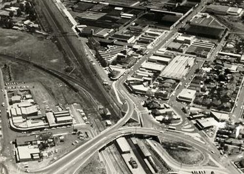
For decades the Sunshine Harvester factory dominated Melbourne’s west. Established in 1904 as the Braybrook Implement Works, in 1906 industrialist H.V. McKay moved his Sunshine Harvester Works to the new township, expanding it to become the largest manufacturing plant in Australia.
Around the factory
In the early years employees had to trudge through mud on their way from Sunshine railway station.

Museums Victoria image MM 93156
But McKay had visions of a company town in Sunshine, including the H.V. McKay Memorial Gardens across the tracks from the railway.
By the 1940s Hampshire Road had also been extensively landscaped.

Museums Victoria image MM 16351
Including the gardens around the railway station.
But in 1960 the entire area was turned into a concrete jungle, when the level crossing was replaced by as tangle of road overpasses.

VPRS 12903/P1, item Box 681/53
Down in the underpass
Access to the railway station was via pedestrian underpasses, including one beneath the northbound off-ramp towards Hampshire Road.

Museums Victoria image MM 92947
But by the 2000s this underpass had been closed.
Boarded up, until someone kicked in the wooden wall.
Inside the underpass was filled with rubbish and debris
The station end bricked up.
A ‘Pedestrian underpass closed’ sign.
Hiding behind the brick wall.
But in 2018 the decision was made to reopen the underpass, as part of the construction of a new bike path alongside Harvester Road towards Albion station.
The brick wall removed.
Murals cover the reopened pedestrian underpass.
Connecting to the new Sunshine-Albion bike path.
Looking much like what used to exist back in the 1960s.
And the footbridge
In 1911 the timber H.V. McKay Footbridge was constructed over the railway, connecting the Sunshine Harvester Works to the McKay Housing Estate on the western side of the tracks.
The bridge was extended in 1930 to cross Harvester Road, and extended further in 1997 as part of the redevelopment of the factory site.
In 2012 it was announced that the footbridge would be demolished due to the Regional Rail Link project.
The replacement bridge opened in 2014, and is 66 metres long.
Dominating the area.


Good summary of the history of the station precinct. I’ve never actually used that pedestrian underpass, certainly not since reopening.
A quibble:
“The bridge was widened in 1930 to cross Harvester Road, further widened in 1997…”
Was the bridge widened, or lengthened?
“The replacement bridge …is 66 metres long.”
Lengthened!
Lengthened, not extended – now corrected!
Similar issue to the present “5K limit” restriction. Should it be extended? Well, that would depend whether “restriction” (chronological/time) or “limit” (distance) is meant!
NICE ❤️
Marcus,
another great article. Have you any idea why the pedestrian underpass was closed?
Unfortunately not. Possible triggers for the change could be the opening of the new City Place station entry in 1994, or the Regional Rail Link rebuild in 2014.
It was closed either 1997 or 2000? Forget which one but 1997 had Harvester Rd works and 2000 bus interchange was redeveloped.
My guess would be when they removed the loop of road under the bridge for pedestrianisation, allowing allowing the relevant pedestrian movements to occur without going under the bridge (rendering it surplus to requirements and thus removing the obstacle to its closure on the grounds of being a dingy underpass).
[…] start in 1960, with Weston Langford standing on platform 2 and 3. Cars still had to use a level crossing, but a timber footbridge allowed pedestrians to avoid waiting for passing […]
[…] north-east side of Sunshine station used to be shaded by a number of tall […]