St Kilda Junction is a horrible place to navigate on foot, with a tangle of concrete flyovers carrying speeding cars and trams over a network of dingy pedestrian subways. But believe it or not, it could have been even worse.

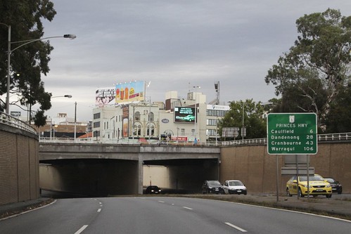
That is something hard to believe while approaching by car.
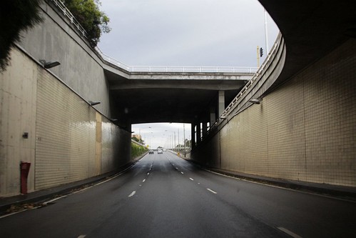
Or driving through the underpasses.
And especially so when waiting for a tram.

But the 1954 Melbourne Metropolitan Planning Scheme proposed a sea of flyovers that puts the current mess to shame.

See the difference?

The back story
St Kilda Junction originally had eight streets meeting in the middle:
- Punt Road
- Nelson Street
- Wellington Street (with trams)
- High Street (with trams)
- Barkly Street
- Fitzroy Street (with trams)
- Queens Road
- St Kilda Road (with trams)
But with the growth in motor vehicle traffic following World War II, the 1954 Melbourne Metropolitan Planning Scheme proposed a major revamp of the intersection.
St Kilda Junction
In any proposal for improving road communications to the southern suburbs, it is impossible to avoid concentrating a considerable volume of traffic at St. Kilda Junction and this junction becomes the most important in the suburban area.
It is estimated that when the city grows to 2,500,000, nearly 120,000 vehicles will pass through this junction in 12 hours. Much of this will be worker traffic to and from the southern suburbs, where car ownership is high. This means that peak hour traffic will be very heavy.
At some stage grade separation of the traffic will be necessary at this point and reservations have been made to allow for this. The type of intersection which will be necessary, and for which the reservations provide, is shown in diagram 29. The first stage should be the construction of the round-about at surface level, for this would immediately improve conditions. When this proves inadequate the grade separation proposals can then be constructed.
As well as massive expansion of the approach roads.
Route 23 follows Dandenong Road, which is already 198 feet wide except between Glenferrie Road, Malvern, and Burke Road, Caulfield, where relatively costly improvement will be necessary eventually to bring it up to the capacity of the rest of the route.
A new route has been provided to eliminate the existing bottleneck in Wellington Street, St. Kilda, and the route then continues along Queen’s Road and Hanna Street. Its connection also to Route 28 will facilitate the movement of traffic to the port, the western suburbs and Geelong.
Route 27 is the main outlet to the bayside suburbs and the beaches beyond. The scheme provides for elimination of the botdeneck in High Street, St. Kilda, to provide a highway 198 feet wide from the Yarra to Gardenvale.
It then continues through Brighton as a deviation of the Nepean Highway to link up at South Road with Route 26, a Country Roads Board project designed to carry the heavy holiday traffic past the seaside suburbs to beyond Frankston.
The proposals being illustrated in this diagram.

So what ended up happening?
Disputes between the St Kilda City Council and the State Government saw the grand grade separation plans shelved, with a temporary roundabout opened in 1955 and made permanent a year later. But road projects never get cancelled – only delayed – with the Melbourne Metropolitan Board of Works (MMBW) building the current network of underpasses in 1966-1970, as well as the widening of the Princes Highway (Route 23 in 1954) and Nepean Highway (Route 27).
Footnote: failed landscaping
The completed St Kilda Junction has so inhospitable that it took a decade for plants to successfully take hold – from the 1979 CRB Annual Report.
St Kilda Junction was reconstructed almost 10 years ago to overcome the serious traffic problems of the then existing junction.
Previous attempts to improve the aesthetics of the new junction area were not successful because of the harsh environmental conditions. Any trees and shrubs planted in the area are required to withstand the wind that is funnelled along the approach roads,the pollutants from the heavy traffic flows and the coastal environment as well as being able to find sufficient moisture in the large paved area.
A scheme was implemented during the year which appears to be successful in overcoming the problems. The scheme utilises a combination of bluestone walls and decorative bluestone paving with both plane trees and native spotted gums, together with shrubs and ground cover plants planted in large raised planting beds. Tree holes of one cubic metre each have been excavated and filled with fertile soil, and a drip feed irrigation system has been installed.
The landscape treatment is in harmony with the various road elements of the junction and integrates the junction visually with both the plane tree avenue in St Kilda Road and the newer plantations in Nepean Highway.
The gum trees are well established 40 years later, but the shrubs seem to have gone.

Further reading
- Car is King – Almost by Christopher Cody

Well just imagine Melbourne when they built this, there was no Monash freeway, no Citylink. And for it’s age it’s certainly lasted. I ponder how old this will become before it needs to be replaced or renovated. It’s also one of the many dinosaurs of Melbourne. Here’s a thing, go to Parliament and take a walk around the outside, most people don’t even see it, they are too busy walking up the steps. But around the back of the building is several flights of steps and a small park. Some of this area has been taken over by temporary buildings but you can see the true vision of the site, and it’s a dinosaur of Melbourne and nobody even notices it. There is true art about that station. But, there are plenty of dinosaurs in Melbourne.
I was looking at photo’s of Flinders Street Station the other day, and I noticed something in the before and after photo’s. The concourse. Inside, this building is great, but on the outside, it’s an eyesore compared to the character of the station. I’ve been taking looks down from buildings and I notice the same thing about the roof of Southern Cross. It’s curved, but it’s so damn ugly. In a city where new buildings are made to look artistic, and we have stations that look so damn ugly. Like, Flinders Street Station is heritage listed, so the concourse building should on the outside at least match well with the building, it doesn’t, it looks like a white square building.
I reckon it would be hard to find any building in Melbourne that has a ‘good’ looking roof – new or old.
https://www.flickr.com/photos/legoblock/albums/72157629640255737
It is shocking at first (and theres a photo of a model of it too !) especially all those slab block around it, but curiously it retains intact the roundabout and the tram lines at grade, so maybe it wouldnt have been so bad ? or only just as bad ? The elevated Queens Rd – Dandenong Rd is a bit shorter, perhaps lots of greenery either side instead of a the current trench, and the elevated roads generaly have lots of space around them – I guess Im influenced by Ian Woodcocks elevated rail promotion, cos here maybe the ground level experience, if landscaped well, would be much better for pedestrian than now, despite parts being under the flyovers where nothing grows.
The at-grade section would’ve been much better for pedestrians, however the cricket ground-sized roundabout negates the advantage. Roundabouts being pedestrian-hostile.
Just like the Haymarket Roundabout – they spent $2.4 million on ‘upgrades’ in 2011, screwed over pedestrians and trams in the process!
https://www.theage.com.au/national/victoria/roundabout-of-death-gets-100000-to-plan-a-safety-upgrade-20170816-gxxtbj.html
At the end of World War II Melbourne’s urban area only extended as far as Oakleigh to the south east and and Moorabbin to the south, plus a thin strip of development along the beaches to Mordialloc and around Chelsea – most suburban trains terminating at Oakleigh and Mordialloc back in the day. Post-war the corridors quickly filled with new suburbs towards Dandenong and Frankston, aided greatly by the electric railways provided back in the early 1920s and making Melbourne’s metropolitan area further lopsided east than it already was. Plans for a new road in what is now the Monash Freeway only extended to Warrigal Road with a connection to Dandenong Road near Atkinston Street before the reservation was soon extended further out.
All this activity quickly placed pressure on St Kilda Junction with the wide Dandenong Road squeezing into a bottleneck at the Sandringham rail overpass just before Chapel Street and through Wellington Street with trams, and a similar arrangement with Nepean Highway becoming the narrow High Street at the junction. This issue would resurface in the 80’s with Dandenong Road widened around Caulfield requiring the demolition of properties to make a six lane divided road and remove the odd arrangement where it fed into Waverley Road and a right turn was required to head towards Oakleigh. On Nepean Highway a similar but larger project was undertaken through Brighton and Gardenvale demolishing properties on the western side to make an eight lane divided highway between Glen Huntly Road and South Road.
The story of Dandenong Road and Nepean Highway being widened is one I’ve always been intending to dig in further – the number of houses demolished to make way for the road is hard to believe in this day and age.
Poor wheelchair access to trams
Dandenong Road has two tram stops only accessible by steps:
https://wongm.com/2021/03/melbourne-tram-stops-step-only-access/
Well, yes, St Kilda Junction as built does have its “issues”. But your photos are kind to it, because they don’t capture the incredible amount of graffiti in the pedestrian underpasses. It seems that the authorities have just given up on this.
I’m aware that in this day and age, some people regard graffiti as “art”, but at the risk of being politically incorrect, I regret to say that I find it ugly. And when it obscures signage – as it does at St Kilda Junction – then surely it’s unacceptable?
You’re right about the pedestrian underpasses being even worse – I only had a quick peek given my visit was to take photos of trams, so I missed getting the full St Kilda Junction ‘experience’.
The same 1950s design for St Kilda Road appears at the 17:14 mark of this 1949 MMBW film titled “Planning For Melbourne’s Future”
[…] tram stop opened in 1969 as part of the St Kilda Junction project, which saw 2 kilometre of tram tracks along Wellington Street relocated to the current grade […]
I am looking for a picture of the Sombrero Cafe, Wellington Street St Kilda in the 60s. Can anybody help me please?
I’ve always wanted to know why accessible stop not put into St Kilda junction for wheelchairs
I seem to recall the bridges underneath the tram tracks being troublesome, but the tram stops themselves seem to be clear of them – so maybe it’s just in the too hard basket given the constrained site.