As you head south on St Kilda Road there is a piece of hidden piece of infrastructure – the underpass that links City Road to Alexandra Avenue.
A quick tour
The road passes beneath the Arts Centre, next to Hamer Hall.
The gardens hide the road beneath.
The only sign at ground level being the parapet on the eastern side of St Kilda Road.
But the traffic sewer dominates the parklands below.
The underpass links Alexandra Avenue to the east.
With City Road to the west.
Five traffic lanes and a dank footpath passing beneath St Kilda Road.
As well as a slip road leading to Sturt Street and the Arts Centre loading dock.
And how it came to be
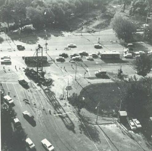
Once upon a time, the corner of St Kilda Road, City Road and Alexandra Avenue was at grade.

1967 photo from the Laurie Richards Collection, Item MM 54017, via Museums Victoria
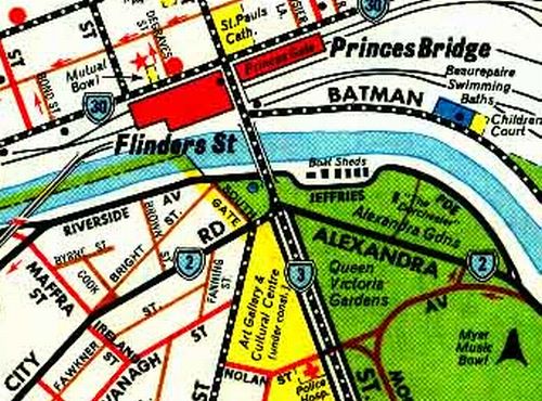
With Melway edition 1 showing the road layout back in 1966.
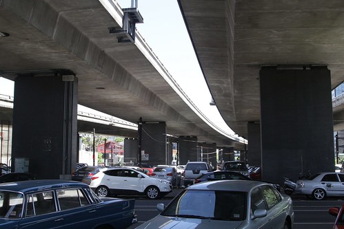
But Melbourne was in the middle of a road building spree, including the City Ring Road and the Swan Street Bridge – completed in 1952.

Photo by fir0002 flagstaffotos [at] gmail.com Canon 20D + Canon 17-40mm f/4 L, via Wikimedia Commons
When proposed in 1946 the classic ‘congestion busting‘ line was given as a reason for construction of the bridge.
The Swan Street Bridge will provide a direct traffic route from South and Port Melbourne to Richmond and Collingwood without having to enter the city proper, and would ease Flinders Street congestion.
But the Town and Country Planning Board indicated in their 1948 annual report that the further road upgrades would be needed to take advantage of the new river crossing.
The Swan Street Bridge was placed on the urgent list by the Metropolitan Town Planning Commission in 1929, was recommended by an expert conference in 1936, and again by the conference called in 1946 by the Hon. P. J. Kennelly, M.L.C., when Minister of Public Works.
The bridge now being built as a continuation of Swan Street across the river will help the traffic problem in many ways. However it will be desirable to construct an underpass at St Kilda Road, either at Alexandra Avenue or Linlithgow Avenue.
Some objections been raised to the use of Alexandra Avenue by commercial vehicles, but the Board points out that the section of the avenue west of Jeffries Parade is now almost unused. Only approximately 1,100 vehicles passed along the section in both directions during the twelve hours of the census in 1947, a reduction of about one-third over the 1926 census figures, although the overall traffic of Melbourne increased by 62 per cent in the twenty years between the two counts.
Some re-arrangement of the unsatisfactory street system on the south bank of the River Yarra in the South Melbourne Municipality to link with the St Kilda Road underpass will also become necessary.
In April 1952 moves were made towards building such an underpass.
£210,000 Plan for Underpass
A. £210,000 traffic underpass is to be built under St Kilda Road at Alexandra Avenue. Cabinet last night instructed the Minister for Public Works (Mr. Byrnes) to prepare necessary legislation for the July session of Parliament. Mr. Byrnes said later he would discuss the work next week with the Metropolitan Board chairman (Mr. J. C Jessop) and the Chief Town
Planner (Mr. K P. Borrie)
The passing of the Melbourne (St Kilda Road Underpass) Lands Bill in 1969 converted Crown Land in the area to a road reserve, enabling Leighton Contractors to start on the project in April 1970.
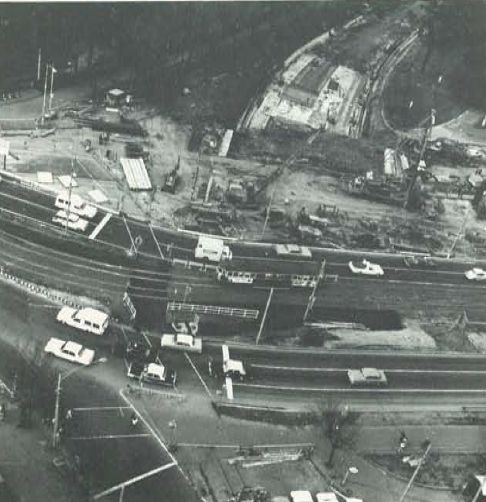
By August 1970 St Kilda Road had been diverted around the work site.
And by June 1971 the eastern approach cutting was almost complete.
Leighton Contractors described the scope of project in their 1971 company newsletter.
St Kilda Road is the main access route for traffic and trams approaching the City from the South. An underpass is being built to ease congestion at this major intersection for the Melbourne and Metropolitan Board of Works. A $2 million contract was awarded in December, 1969, and reconstruction of nearby streets was begun so that work on the main structure and approach roads could begin in April, 1970.
The underpass structure has to be built in three phases so that traffic flow in St Kilda Road is not interrupted. Numerous underground and overhead services severely restrict the sequence of work.
Main construction items are:-
- 3 ft. and 8 ft. diameter cast in situ piles socketted into rock 100 ft. below surface.
- Driving of 7,000 ft. of prestressed concrete sheet piles.
- Erection of forty 110 ft. long precast concrete beams weighing up to 35 tons. Each of these is pretensioned in the factory and post tensioned on site.
- Excavation of 80,000 cu.yds, of various materials.
- Construction of 2,700 ft. of drainage lines including a 42″ diameter outfall into the Yarra River. A length of 180 ft. of this outfall was installed by jacking the pipes through an embankment.
- Constructing 1,600 ft. of concrete retaining walls up to 20 ft. high. These walls are specially shaped to deflect runaway vehicles.
- Providing various approach roads with both flexible and rigid pavements of various types.
- Building sawn basalt stonework to match that used on the adjoining Arts Centre.
The structure is being built over the old bed of the Yarra and during excavation numerous clay smoking pipes and old bottles of many shapes were recovered. Unfortunately most of the bottles were broken and all were empty. A brick kiln existed on the site many years ago and hundreds of old bricks have been dug out.
Despite these diversions the project should be finished by the end of the year.
Resulting in the road layout seen today.
Traffic using the underpass continued to grow, fed by the new West Gate Freeway through South Melbourne from 1987.
The road serving as the main link between the eastern and western suburbs of Melbourne.
Until 2000 when the Burnley and Domain Tunnels were opened as part of the CityLink project.
But the underpass is still busy today, due to overheight vehicles and dangerous goods tankers, neither of which can use the tunnels.
And don’t forget the trams!
Route 1 trams to South Melbourne once followed the entire length of Sturt Street, being diverted to Nolan Street (now called Southbank Boulevard) to make way for the underpass.
18 May 1969
A track junction was installed at Nolan Street in St Kilda Road, in preparation for diversion of the South Melbourne Beach route due to construction of the City Road underpass.
16 March 1970
A new track in Nolan Street, South Melbourne, was opened, from Sturt Street to St Kilda Road. It replaced the track in Sturt Street from Nolan Street to City Road, which was abandoned due to construction of the City Road underpass. A crossover was provided in Nolan Street at St Kilda Road.
By 1971 St Kilda Road trams were using temporary tracks around the work site, with the Edmund Fitzgibbon Memorial at the southern end of Princes Bridge also relocated for the underpass.
Ghost ramps?
The map 43 in the 1970 Melway directory feature ramps between St Kilda Road and the underpass – did they ever exist, or something descoped from the initial plans?
And the Victorian Arts Centre
The remaining Crown land between the underpass and the Yarra River was then permanently reserved as a site for the Victorian Arts Centre under the Melbourne (Snowden Gardens) Land Act 1975.
A Place Across the River: They Aspired to Create the Victorian Arts Centre by Vicki Fairfax details the saga behind that project.
Footnote: enabling legislation
Four pieces of Crown land were acquired for the underpass via the Melbourne (St Kilda Road Underpass) Lands Bill 1969.
North-west corner.
Whereas by Order in Council dated the 3rd day of February, 1914 certain Crown lands in the City of Melbourne were permanently reserved as a site for ornamental purposes and were vested in the corporation of the City of Melbourne by Order in Council of the 13th day of November, 1917 pursuant to the provisions of paragraph (b) of sub-section (1) of section 4 of the Prince’s Bridge Approach Act 1900.
South-east corner.
Whereas by an Order in Council dated the 8th day of May, 1905 certain Crown lands in the City of Melbourne were permanently reserved as a site for a memorial statue of Her late Majesty Queen Victoria and a public garden and Crown grant dated the 9th day of November, 1905.
Eastern side.
Whereas by an Order in Council dated the 5th day of August, 1913 certain Crown lands in the City of Melbourne were permanently reserved as a site for a public park for the recreation and amusement of His Majesty’s subjects and people designated the Alexandra Park and Crown grant dated the 18th day of December, 1917.
And south-west corner.
Whereas by an Order in Council dated the’ 7th day of May, 1957 certain Crown lands in the Cities of Melbourne and South Melbourne were permanently reserved as a site for a National Art Gallery and Cultural Centre and pursuant to the provisions of section 5 of the National Art Gallery and Cultural Centre Act 1956 Crown grant dated the 30th day of July, 1957.


From memory there was for many years a tram stop directly above the City Road underpass, in the middle of St Kilda Road, with steps from the underpass’s dank footpath – or was there a separate underpass to the tram stop?
I’m guessing if it did exist, it was removed following the construction of the third track section in June 2008:
http://vicsig.net/photo/9132
Tram at the Arts Centre in 2004 – I *think* that’s a fence right behind it, same style of parapets as the eastern side of St Kilda Road.
http://vicsig.net/photo/1108
And a 2007 photo, showing a set of steps at the south end of the tram stop.
http://vicsig.net/photo/8373
http://vicsig.net/photo/8377
I’ve since found a clearer photo of the stairs – the sign above it reads ‘Underpass to Sturt Street’.
https://www.facebook.com/MelbournesWClassTrams/photos/pcb.10156709717481041/10156709713936041
Yes there were steps from Arts Centre theatres building to down under St Kilda Road, where an elevated path runs along the south side of City Road. Up until the construction of the Arts Precinct Super Stop tram stop which necessitated moving the stop itself a little further south from the original site, there were steps that came up to the tram stop in the middle of the road. However, that has been filled in and lies under the asphalt & tram tracks now. The steps from Arts Centre down to City Road elevated footpath are still extant, however I’m unsure if they are currently accessible due to major works at the Arts Centre site where City Road’s Sturt Street exit is now permanently closed to traffic to become an urban park that links the two elevations down from the current grass area between theatres/hamer hall building down into former 1-4 Sturt Street (ending in Southbank Boulevard, formerly known as Nolan Street)
I wonder how the changing plans for the Arts Centre around this time influenced the removal of Alexandra Avenue and City Road to kill two birds with the one stone.
The main site acquired for the ‘cultural centre’ was previously Wirths permanent circus or ‘Olympia’ as it was called plus roller skating rink with the corner nearest the current underpass being later a dance hall with Dutch windmill front called the Trocadero. The Oympia was destroyed by fire in the early 50s leaving the site mostly parking with the Trocadero standing alone from that point:
https://performingartscollection.files.wordpress.com/2016/09/aerial-sitemm_71900-800×800.jpg?w=562&h=715
The Trocadero hall became the first casualty for the Art Gallery which was built as planned opening in 1968 as Stage 1 of the cultural centre. Stage 2 as originally planned was for a concert hall and theatres to be built under a single copper dome largely underground – problems soon arose as the cost of the plan was too much given the challenging site conditions as it was in an old course of the river in the same alluvial material the new underpass was constructed in with the obligatory water table issues:
http://www.thecollectormm.com.au/private/ArtsSpire1.jpg
https://cdn.newsapi.com.au/image/v1/c3ca55bd79abc4ed59fed66f251599ae?width=650
The solution in the end was to build two separate buildings with the theatres raised relative to the original plan, in part helped by the lowered road nearby with the separate concert hall next to the current course of the river on the Snowden Gardens site – on a foundation of basalt rock closer to the surface. A grassed area between the two was provided by extending the underpass west to what is seen today.
Thanks for the extra history.
another fantastic post Marcus!
Glad you enjoyed it!
Interesting little forgotten rule about dangerous goods being prohibited in the tunnels, I wonder when they got rid of that bylaw as obviously no long applies.
The “Road Transport (Dangerous Goods) Act 1995” banned dangerous goods from the CityLink tunnels:
https://content.api.worksafe.vic.gov.au/sites/default/files/2018-06/ISBN-Transport-of-dangerous-goods-CityLink-1999-12.pdf
The “Dangerous Goods (Explosives) Amendment Regulations 2008” expanded them to cover the EastLink tunnels:
http://www.legislation.vic.gov.au/Domino/Web_Notes/LDMS/PubStatbook.nsf/93eb987ebadd283dca256e92000e4069/A25A577D3E2E61E2CA25742C00224AAF/$FILE/08-024sr.pdf
[…] 14 on St Kilda Road at the Arts Centre once had a set of stairs connecting it to the City Road underpass – opened in 1971 it was replaced by the current […]
[…] from there the trail goes cold. Following completion of the Arts Centre underpass, construction of the Melbourne Concert Hall (now Hamer Hall) commenced on the site of the fountains […]