If you take a look the Melbourne tram network map, you’d reasonably expect that the lines drawn on it are the limits of where you can ride. But there are a number of places across Melbourne were trams can roam but passengers cannot.

Secret cross-town connections
Melbourne’s tram system is primary a radial one, with every route except for 78 and 82 running via the CBD. However, there are a handful of cross-town connections allowing trams to avoid the city.
On the northern edge of the Melbourne CBD there is a connection that doesn’t appear on the network map – 300 metres of track along Victoria Street between Swanston and Elizabeth Streets.

The link was opened in the 1920s to connect the isolated North Melbourne Electric Tramways & Lighting Company system to the rest of the system.
Today it permits the transfer of empty trams between depots for maintenance, the diversion of route 58 trams due to disruptions in the CBD, and for special trams on Anzac Day to access the Shine of Remembrance for the dawn service.
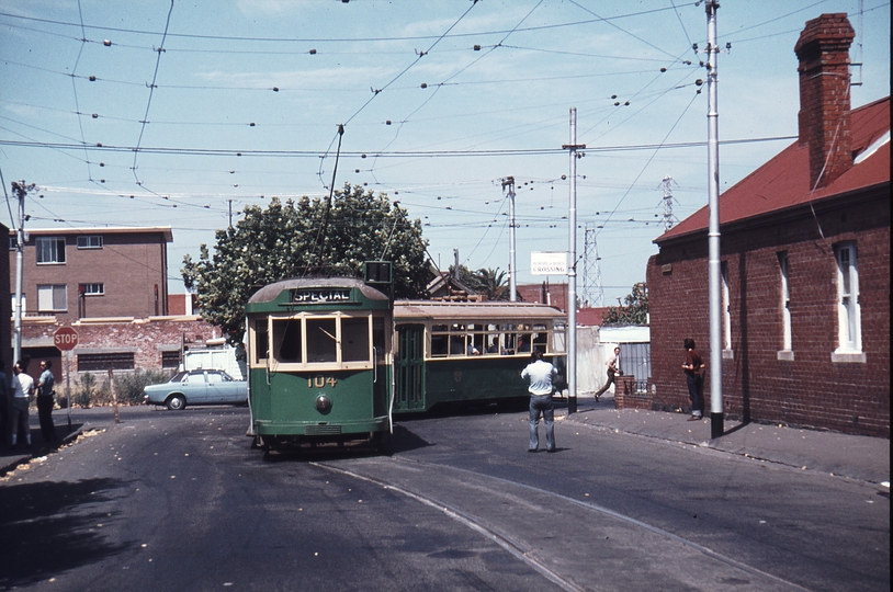
Another hidden connection is much further from the city – 580 metres of track along Miller Street in Preston. It links route 86 on High Street to route 11 along St Georges Road, via a bridge over the Mernda railway line.

The link was part of the original Fitzroy, Northcote & Preston Tramways Trust network, it was once used by passenger services but was made redundant following the conversion of cable tramways to electricity, permitting through running along High Street.
Today the connection allows trams to access Preston Workshops and East Preston depot without travelling all the way back into the city.
The appendixes of the tram network
Also not shown on the network map are a number of dead end stub tracks.
The north end of William Street at Dudley Street is one, where route 58 trams diverge into Peel Street.

Once upon a time passengers from the southern suburbs had two options to reach the city – trams via St Kilda Road and Swanston Street, or Kings Way and William Street. The latter services terminated at Dudley Street until they were withdrawn in 1986, with the sidings seeing little use since.
Spencer Street north of La Trobe Street has a single track stub.

Used as the route 75 terminus until it was relocated to Docklands, today the stub is used to turnback lunchtime extra for Bourke Street, and Grand Prix specials.
Route 12 also has a seldom used track stub – running along Mills Street towards Albert Park Beach.

It’s claim to fame – it has never been used by timetabled trams.
Sidings for special events
Trams carry passengers to many big events across Melbourne, so a number of sidings exist across the network to park extra trams ready for special event crowds to head home.
Footy fans headed home from the MCG are served by the dead end Simpson Street sidings at the end of Wellington Parade.

While tennis fans have served by the Melbourne Park tram siding on route 70 to the south.

Docklands Stadium is served by trams from the Footscray Road siding, located north of Dudley Street.

Trams to Flemington Racecourse and the Showgrounds use the Showgrounds Loop on Union Road in Ascot Vale.

The South Melbourne Football Club might have left Lakeside Oval, but South Melbourne Loop on route 12 is still there.

And raceday crowds at Caulfield Racecourse are also down, but the tram siding in the middle of Dandenong Road remains.

Tram termini and layovers
Trams can’t instantly change direction – the tram driver needs to lock up before walking down to the other cab. For this reason tram termini often have sidings to free up the ‘though’ tracks for passing trams.
Melbourne University has three dead end sidings facing south for terminating trams.

Route 12 in Richmond has a turnback outside the Victoria Gardens shopping centre.

Route 30 has a dead end siding just past the St Vincent’s Plaza tram stop.

And route 82 has a turnback siding at Moonee Ponds Junction.

The route 96 terminus at East Brunswick is a dead end, but has two sidings beyond the tram stop for trams to lay over.

As does Waterfront City in Docklands.

And finally, St Kilda Road at the Arts Centre has a short section of third track, allowing defective trams to be parked clear of other services.

Tram depots
Melbourne’s fleet of trams is housed at eight depots around the city. Each depot has an array of tracks leading into the sheds and storage roads.

Brunswick Depot has a non-passenger carrying section of track connecting it to the rest of the network.

As does Camberwell Depot.

Reconnecting dead ends
The tram network map suggests that when tram routes intersect, you need to get out and change trams to turn the corner. But if you take a look on the ground, you might see a set of connecting curves exist between the two intersecting tracks, allowing trams to weave their way across the network as they please.
Route 109 passes the northern end of route 78, 16 and 72 as it heads east to Box Hill, they aren’t necessarily a dead end for trams – curves link connects Church Street to Victoria Street.

And Cotham Road to Glenferrie Road.

The route 12 terminus in St Kilda has a connection to route 96 along Fitzroy Street.

The route 58 terminus on Toorak Road has a connection to route 16 along Glenferrie Road.

And route 78 at Balaclava has a connection to route 67 along Nepean Highway.
Connecting curves
Where tram routes cross over is another places where trams can weave their way across the network as they please – thanks to curves that allow trams to change from one street to the other.

The curves at Swanston Street and La Trobe Street, along with those at William Street and La Trobe Street, are a frequently used diversion route through the CBD for routes that normally use Swanston Street.

Curves at Nicholson Street and Victoria Street provide Bourke Street routes an alternate path through the CBD.

And those at Kings Way and Sturt Street provide a detour around St Kilda Road.

But other connections are seldom used, like those at Clarendon and Park Street in South Melbourne.

And Church and Swan Streets in Richmond.

And the granddaddy of them all – the ‘grand union’ at Balaclava Junction that allows trams from any direction to take any other directions.

Route 3, 16, and 64 trams use the junction, but only the north / west leg of the junction is used by passenger services.
A stub that is gone
The Essendon Football Ground at ‘Windy Hill’ was once served by trams, thanks to a stub along Napier Street leading north from the route 59 tracks. Essendon’s relocation to the MCG saw the siding made redundant, but the siding was not removed until 2004.
A removed connection
Once upon a time there was a 1.5 kilometre long cross-town tramway along Holden Street in North Fitzroy, until it was dismantled in the 1970s.
Constructed to link the isolated Fitzroy, Northcote & Preston Tramways Trust system to the rest of the electric network while avoiding the existing cable tramway network, this connection commenced on routes 1/6 at Lygon Street, crossing over route 96 at Nicholson Street, and headed east towards St George’s Road, where it snaked via Pilkington Street and Barkly Street to reach what is now route 11.
Conversion of the cable trams to electric rendered the connection redundant, but a shuttle service running along Holden Street continued until the 1950s.
A cross-town connection we almost got
In 2007 as part of the planning for the ‘New’ Preston Depot on St Georges Road, another cross-town tramway connection was proposed.

The connection being described as.
Track Links is new track to give connection from the Preston Depot (workshops site) to routes 96 (Nicholson Street) and routes 1/8 (Lygon Street). There are four options.
- Option A – Link down Arthurton and Blyth Streets from St. Georges Road to Lygon Street.
- Option B is a combination of A and C, ie Arthurton/Blyth Streets from St.Georges Road to Nicholson Street, and Brunswick Road from Nicholson Street to Lygon Street.
- Option C – Holden Street and Brunswick Road from St.Georges Road to Lygon Street.
- Option D – Park Street (next to old Inner Circle train line) from St.Georges Road to Lygon Street.
However it was not to be – ‘New’ Preston Depot opened in April 2016, replacing East Preston, but only housing E class trams for route 11, 86 and 96.
And a connection that isn’t there
For some reason the route 72 terminus in Burke Road isn’t connected to the route 109 tracks along Whitehorse Road.

The nearest connection to the rest of the network is 7.5 kilometres away – at Glenferrie Road and High Street in Malvern!
So what can you do with all these connections?
Back in the 1920s the ‘Shilling Tour’ tram took advantage of the little used curves, taking tourists around the eastern and south-eastern suburbs of Melbourne.

While in the 1990s another ‘mystery’ tour of Melbourne was launched – the route 99 “NightLink” tram running from Fitzroy to St Kilda, Chapel Street, and Richmond.
And finally, tram enthusiasts have organised their own private tours of the network, traversing the hidden cross-town connections, and stopping for photos at little used sidings.

Back in 2012 I went on a tour of the western suburbs to commemorate the closure of the Footscray tramways, in 2016 a farewell tour for B1 class trams, and a 2017 tour that tried to visit as many places called ‘park’ as possible.
Sources
- A timeline history of the Melbourne electric tramways by Don Storey
- Melbourne CBD diagram by Mal Rowe showing tram tracks, curves, crossovers and sidings.
- 1979 track diagram for the Melbourne tram network.
- Destination Waterfront City: A Guide to Melbourne’s Trams by Dale Budd and Randall Wilson has a full track map of the Melbourne tram network, including cross-town connections, sidings, curves and crossovers.

Route 58 also has layover tracks at Bell St terminus after upgrade last year.
I’d forgotten about that one – details are here.
http://web.archive.org/web/20200307132250/https://getinvolved.transport.vic.gov.au/melville-road-tram-stop
The Hump, the Miller Street connection between St Georges Road and High Street, used to be travelled by passengers using the route 9 Northcote via St Georges Road tram.
I think there was once a curve from Burke Road into Whitehorse Road before Kew and Camberwell Depots were built and the then Deepdene tram was run by Malvern Depot.
Many curves have been removed over time, and many added. When Camberwell Junction track was relaid Yarra Trams Mk1 insisted the curves from Riversdale Road into Burke Road not be replaced as M Tram was not allowed to run their trams for any reason in Riversdale Road.
Special permission had to be granted by YT to M Tram for a diverting route 16 along the 96 light rail if there was a disruption affecting the 16. Farcical.
Maybe that was Swanston trams rather than M Tram.
More or less a result of what happens when you split the running of the Tram and Train systems after 1999.
I still remember the old curves there.
What about the short tram track running parallel to the Mernda train line. Near to Preston depot?
I’d also forgotten about that one – the test track at Preston Workshops.
The relief drivers on route 11 used to drive a tram as the transport car between Preston Depot and Thornbury. They actually took passengers, which I enjoyed riding. Such a genuine tradition discontinued after the W class crisis in 2000, when the transport cars became road vehicles. Even if a tram was occasionally deployed due to either the relief or the relieved driver was a senior driver who joined before 1984 and did not have a car license, or a driver who joined with a motorcycle license, they were reluctant to take passengers anymore.
There used to be a single south – west connecting curve connecting Camberwell and Deepdene, which got removed as it was deemed too difficult to make a shunt on a slope (but the Deepdene crossover didn’t get relocated until recent years).
I’m disappointed that the north – west curves at Park & Clarendon Sts got removed, but strangely the rarely used south – east curves remain. The last use of the latter was by a tram tour using one of the newly refurbished B class trams early this century. Surely different procedures would be required after the hook turn was introduced, but it should be easy enough to insert an independent white T or white arrow phase. The route 1 trams diverting via this route was actually faster than the normal route. Now they have to divert via William St. which is much more difficult to drive.
The connecting curves at Glenferrie & Riversdale Rds is often used by tram transfers, but the stop line for north bound road vehicles fouls the left curve. Left turning trams often have to wait for several light cycles for an understanding motorist to stop behind the curve, or for the next tram to arrive, and the driver alighting to stop road traffic.
I have always doubted the necessity of the Arts Centre siding. It imposes a compulsory stop for all service cars where there is no passenger stop, but what’s the likelihood that a tram happens to become defective around there but is still able to be driven into the siding? You can’t set the points and free wheel into it as this would have violated the compulsory stop. Of course trams can terminate there when there is a blockage in the CBD, but the original single crossover at City Rd. would serve the same purpose. You don’t have to worry about trams occupying the mainline to shunt because when the CBD is blocked and all trams shunt there, it’s not a mainline anymore.
Possibly Melbourne’s shortest tram route was the No 9 along Miller St as a Northcote – Thornbury shuttle. Its run time was just 2 min. I believe its service closed in 1993.
1989 timetable on Krustylink here: https://sites.google.com/site/melbtramtt009013014/26-june-1989-timetable
Also on the 1989 map here https://sites.google.com/site/melbptbrochures/travel-guides
The Wikipedia list though shows 9 as a city route https://en.wikipedia.org/wiki/List_of_Melbourne_tram_routes
I suspect it was cut back to the short shuttle in the big 1986 round of duplicative tram route cuts, like when the St Kilda Rd-Willam St routes went.
The 14 (also a 1986 cut I believe), was similar to the 9 but went all the way to East Preston terminus. Had that been retained and extended with the line to Latrobe Uni, it would probably be a useful route (at least in non-pandemic times). It might even justify restoration, although probably not at the moment.
Holden St would probably be a useful tram route these days (at least in non-pandemic times), with all the density in East Brunswick, it could provide useful extra capacity on Lygon St (by extending one of the Melb Uni tram routes, probably the 5 for single digit simplicity) and also help relieve the 96 (or alternately a second Holden St route using Nicholson St).
Fixing the east west bus routes in the inner north is a cheaper option.
https://melbourneontransit.blogspot.com/2019/07/building-melbournes-useful-network-part_5.html
The stub that goes from Lygon Street to Brunswick Road is still there if you look closely.
The points were removed a while back, but the curve and part of the siding is still there.
I don`t doubt it is cheaper to upgrade the buses these days. It was more of a “if it had survived (particularly as double track), it would be useful”.
I believe route 14 once did go to LaTrobe University. If that was reinstated as a regular service, it would be quite competitive to the train and route 301 express shuttle option.
There are also a couple of sections which never see trams due to the tracks being cut off from the network but not removed, such as the old route 8/58 section along Domain Rd and Park St (cut off for the Metro Tunnel/Anzac Station works, although having trams running along Toorak Rd West is actually better since it’s more direct, and the former route served nothing in particular aside from the northern side of Melbourne Grammar and a lonely 7-Eleven). Docklands also has some abandoned tram tracks.
Former stop 24 Botanical Gardens is missed.
Re tram stop 24 Botanical Gardens – in effect, it’s been replaced by the re-routed route 605 bus service, and the Merton Hall girls have got their own stop in Anderson St too. But it’s not the same, is it?
Well, the weekend frequency of route 605 is almost unusable if you arrive at the stop at a random time.
The abandoned tram tracks in Docklands are parallel to Harbour Esplanade.
They were taken out of service in 2010 when the tracks were moved into the centre of Harbour Esplanade.
https://www.docklandsnews.com.au/editions/article/stand-by-for-traffic-chaos_5525/
The 14 definitely survived 1986 – see the times marked A in the 1986 route 9 timetable on Krustylink: https://docs.google.com/viewer?a=v&pid=sites&srcid=ZGVmYXVsdGRvbWFpbnxtZWxidHJhbXR0MDA5MDEzMDE0fGd4OjQ1ZmI5ZGU5MDI3ZmI5NjQ
From memory, the 14 even ran to the original Bundoora terminus at some point (maybe a limited number of trips extended from LaTrobe Uni from 1986 until 1989?) – there’s at least one photo somewhere on the internet of a W class at the Bundoora shops terminus on a route 14. As a semi-local resident, I definitely remember seeing some rarely in peak hour – a W class in amongst the Zs didn’t go unnoticed!
[…] the case of trams, there are crossovers all over Melbourne, giving trams the flexibility to terminate and return at places that aren’t the usual end of […]
[…] And parked at the end of the Footscray Road siding, a location passengers never visit. […]
When I was a child can remember a curve from Swan st into Church st Richmond heading to north Richmond , this is back in the 50s .
[…] so I headed back up to the surface and stepped into the middle of La Trobe Street to photograph a diverted route 12a tram, when a police car pulled up beside me, and the officer inside said “you can’t stand in […]
A cross town connection that we should get in the future is along Moreland road from the current route 6 terminus to Melville road. This would allow the Brunswick depot to serve route 58 and be useful for diversions such as during the Sydney road festival.
Only 1.5 km long, and there isn’t even a level crossing in the way any more.
https://www.google.com/maps/dir/-37.7552929,144.9621644/-37.7532781,144.9458094/@-37.7553094,144.9486766,15.71z/data=!4m2!4m1!3e2?entry=ttu
Do you mean it would be a good tram extension?
Given route 6 already does the western leg as far the Upfield line, a short extension to form a longer crosstown connection would be good.
And with the extension, route 6 would now do its western leg at least as far as the John Fawkner Hospital.
I had been thinking of the extension ever since grade separation of that level crossing was announced.
Good for the reasons I mention? Any idea how cheap this extension would be being less than 2km long?